world.wikisort.org - France
Bar-le-Duc (French pronunciation: [baʁ lə dyk] (![]() listen)), formerly known as Bar, is a commune in the Meuse département, of which it is the capital. The department is in Grand Est in northeastern France.[3]
listen)), formerly known as Bar, is a commune in the Meuse département, of which it is the capital. The department is in Grand Est in northeastern France.[3]
This article needs additional citations for verification. (February 2012) |
Bar-le-Duc | |
|---|---|
Prefecture and commune | |
 Clock tower | |
 Coat of arms | |
Location of Bar-le-Duc  | |
 Bar-le-Duc  Bar-le-Duc | |
| Coordinates: 48°46′19″N 5°09′37″E | |
| Country | France |
| Region | Grand Est |
| Department | Meuse |
| Arrondissement | Bar-le-Duc |
| Canton | Bar-le-Duc-1 and 2 |
| Intercommunality | CA Bar-le-Duc - Sud Meuse |
| Government | |
| • Mayor (2020–2026) | Martine Joly[1] (MR) |
| Area 1 | 23.62 km2 (9.12 sq mi) |
| Population | 14,625 |
| • Density | 620/km2 (1,600/sq mi) |
| Time zone | UTC+01:00 (CET) |
| • Summer (DST) | UTC+02:00 (CEST) |
| INSEE/Postal code | 55029 /55000 |
| Elevation | 175–327 m (574–1,073 ft) (avg. 240 m or 790 ft) |
| 1 French Land Register data, which excludes lakes, ponds, glaciers > 1 km2 (0.386 sq mi or 247 acres) and river estuaries. | |
The lower, more modern and busier part of the town extends along a narrow valley, shut in by wooded or vine-clad hills, and is traversed throughout its length by the Ornain, which is crossed by several bridges. It is limited towards the north-east by the Marne–Rhine Canal, on the south-west by a small arm of the Ornain, called the Canal des Usines, on the left bank of which the upper town (Ville Haute) is situated.[4]
The highly rarefied Bar-le-duc jelly, also known as Lorraine jelly, is a spreadable preparation of white currant or red currant fruit preserves, hailing from this town. First referenced in the historical record in 1344, it is also colloquially referred to as "Bar caviar".
History

Bar-le-Duc was at one time the seat of the county, from 1354 the Duchy of Bar. Though probably of ancient origin, the town was unimportant until the 10th century when it was fortified by Frederick I of Upper Lorraine.[4] Bar was an independent duchy from 1354 to 1480, when it was acquired by Duchy of Lorraine.
The Ville Haute, which is reached by staircases and steep narrow thoroughfares, is intersected by a long, quiet street, bordered by houses of the 15th, 16th and 17th centuries. In this quarter are the remains (16th-century) of the château of the dukes of Bar, dismantled in 1670, the old clock-tower, and the college, built in the latter half of the 16th century. Its church of Saint-Étienne (constructed during the 14th and 15th centuries) contains the Cadaver Tomb of René of Chalon, a skillfully carved effigy in white stone of a half-decayed corpse. It was erected to the memory of René of Châlon (died 1544), and is the work of 16th-century artist Ligier Richier, a pupil of Michelangelo.[4]
The lower town contains the official buildings and the churches of Notre-Dame, the most ancient in the town, and St. Antony, with 14th-century frescoes. Among the statues of distinguished natives of the town is one of Nicolas Oudinot, whose house serves as the hôtel-de-ville.[4] Other sights include the Notre-Dame Bridge, with five arches surmounted by a chapel in the middle.
Bar-le-Duc served as the assembly point for essential supplies going to the besieged city of Verdun during the Battle of Verdun in 1916. Thousands of trucks, carrying men, equipment and food, traveled north, around the clock, on the road linking Bar-le-Duc to Verdun. The route was given the name Voie Sacrée, which translates to Sacred Way, by the writer and politician Maurice Barres in April 1916, a reference to the ancient Roman Sacra Via, leading to triumph.
Population
|
| ||||||||||||||||||||||||||||||||||||||||||||||||||||||||||||||||||||||||||||||||||||||||||||||||||||||||||||||||||
| Source: EHESS[5] and INSEE (1968-2017)[6] | |||||||||||||||||||||||||||||||||||||||||||||||||||||||||||||||||||||||||||||||||||||||||||||||||||||||||||||||||||
Notable residents
This article's list of residents may not follow Wikipedia's verifiability policy. (April 2019) |
Bar-le-Duc was the birthplace of:
- Jean de Lorraine (1498–1550), Cardinal de Lorraine, Bishop of Metz, Archbishop of Narbonne
- Mary of Guise (1515–1560), queen consort of Scotland and mother of Mary, Queen of Scots
- Francis, Duke of Guise (1519–1563), soldier and politician
- Louis Joblot (1645–1723), mathematician and microscopist
- Nicolas Oudinot (1767–1847), marshal of France
- Jean-Joseph Regnault-Warin (1773–1844), writer, pamphleteer
- Rémi Joseph Isidore Exelmans (1775–1852), marshal of France
- Pierre Michaux (1813–1883) inventor
- Edmond Laguerre (1834–1886), mathematician
- Albert Cim (1845–1924), novelist, literary critic and bibliographer
- Job (1858–1931), illustrator
- Raymond Poincaré (1860–1934), statesman
- Pierre de Bréville (1861–1944), composer
- Pierre Camonin (1903–2003), canon and organist
- Jean Dries (1905–1973), painter
- Michel Bernard (born 1958), writer and senior official
- Benjamin Compaoré (1987–), athlete
- Anaïs Delva (born 1986), singer and actress
Other notable residents were:
- Jean-François Jacqueminot (1787–1865), who established a great silk factory
- Ernest Bradfer (1833–1882), who established a major iron works in the town.
Gallery
 Saint-Étienne Church and the court house (right) on the Saint-Pierre Square in Bar-le-Duc
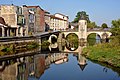 Notre-Dame Bridge over the Ornain
 Statue of Ernest Bradfer (1833–1882)


Twin cities
Bar-le-Duc is twinned with:
 Tambov, Russia
 Griesheim, Germany, since 1978.
- Wilkau-Haßlau, Germany, since 1994.
 Gyönk, Hungary, since 1995.
See also
| Part of a series on |
| Lorraine |
|---|
 |
- Battle of Bar-le-Duc (1037)
- Communes of the Meuse department
- Parc naturel régional de Lorraine
- Raymond Couvègnes
References
- "Répertoire national des élus: les maires". data.gouv.fr, Plateforme ouverte des données publiques françaises (in French). 2 December 2020.
- "Populations légales 2019". The National Institute of Statistics and Economic Studies. 29 December 2021.
- INSEE commune file for Bar-le-Duc
- One or more of the preceding sentences incorporates text from a publication now in the public domain: Chisholm, Hugh, ed. (1911). "Bar-le-Duc". Encyclopædia Britannica. Vol. 3 (11th ed.). Cambridge University Press. p. 404.
- Des villages de Cassini aux communes d'aujourd'hui: Commune data sheet Bar-le-Duc, EHESS. (in French)
- Population en historique depuis 1968, INSEE
External links
| |||||
|
Authority control | |
|---|---|
| General | |
| National libraries | |
| Other |
|
На других языках
- [en] Bar-le-Duc
[ru] Бар-ле-Дюк
Бар-ле-Дюк (фр. Bar-le-Duc) — главный город французского департамента Мёз, занимающий узкую долину реки Орнен к западу от Нанси, поблизости Заводского канала и канала Рейн-Марна. Холмы по сторонам от города покрыты перелесками и виноградными садами. Население 16 944 жителей (1999).Другой контент может иметь иную лицензию. Перед использованием материалов сайта WikiSort.org внимательно изучите правила лицензирования конкретных элементов наполнения сайта.
WikiSort.org - проект по пересортировке и дополнению контента Википедии