world.wikisort.org - France
Le Palais (French pronunciation: [lə palɛ]; Breton: Porzh-Lae) is a commune in the Morbihan department of Brittany in northwestern France.[3] It is one of the four communes on the island of Belle Île.
Le Palais
Porzh-Lae | |
|---|---|
Commune | |
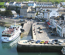
 Ferry in the harbour | |
 Flag  Coat of arms | |
Location of Le Palais  | |
 Le Palais  Le Palais | |
| Coordinates: 47°20′50″N 3°09′15″W | |
| Country | France |
| Region | Brittany |
| Department | Morbihan |
| Arrondissement | Lorient |
| Canton | Quiberon |
| Intercommunality | Belle-Île-en-Mer |
| Government | |
| • Mayor (2020–2026) | Tibault Grollemund[1] |
| Area 1 | 17.43 km2 (6.73 sq mi) |
| Population | 2,544 |
| • Density | 150/km2 (380/sq mi) |
| Time zone | UTC+01:00 (CET) |
| • Summer (DST) | UTC+02:00 (CEST) |
| INSEE/Postal code | 56152 /56360 |
| Elevation | 0–58 m (0–190 ft) |
| 1 French Land Register data, which excludes lakes, ponds, glaciers > 1 km2 (0.386 sq mi or 247 acres) and river estuaries. | |
Inhabitants of Le Palais are called in French Palantins.
Geography
Le Palais is one of the four communes of Belle île en Mer. It is the most populated. It houses the administrative center and the main port of the island. The town centre is located 4.5 km (2.8 mi) northeast of Bangor, 5.8 km (3.6 mi) southeast of Sauzon and 8 km (5.0 mi) northwest of Locmaria.
Map
Population
Le Palais's population peaks in 1872.
|
|
| |||||||||||||||||||||||||||||||||||||||||||||||||||||||||||||||||||||||||||||||||||||||||||||||||||||||||||||||||||||
| Source: EHESS[4] and INSEE (1968-2019)[5] | |||||||||||||||||||||||||||||||||||||||||||||||||||||||||||||||||||||||||||||||||||||||||||||||||||||||||||||||||||||||
See also
References
- "Maires du Morbihan" (PDF). Préfecture du Morbihan. 7 July 2020.
- "Populations légales 2019". The National Institute of Statistics and Economic Studies. 29 December 2021.
- INSEE commune file
- Des villages de Cassini aux communes d'aujourd'hui: Commune data sheet Le Palais, EHESS. (in French)
- , INSEE
External links
Wikimedia Commons has media related to Le Palais.
- Base Mérimée: Search for heritage in the commune, Ministère français de la Culture. (in French)
- Mayors of Morbihan Association (in French)
На других языках
[de] Le Palais
Le Palais (bretonisch Porzh-Lae) ist eine französische Gemeinde mit 2544 Einwohnern (Stand 1. Januar 2019) im Département Morbihan in der Region Bretagne auf der Atlantik-Insel Belle-Île.- [en] Le Palais
[fr] Le Palais
Le Palais [lə palɛ] est une commune française située sur l'île de Belle-Île-en-Mer dans le département du Morbihan et la région de Bretagne.[ru] Ле-Пале
Ле-Пале (фр. Le Palais, брет. Porzh-Lae) — коммуна в составе департамента Морбиан, одна из четырёх коммун острова Бель-Иль.Текст в блоке "Читать" взят с сайта "Википедия" и доступен по лицензии Creative Commons Attribution-ShareAlike; в отдельных случаях могут действовать дополнительные условия.
Другой контент может иметь иную лицензию. Перед использованием материалов сайта WikiSort.org внимательно изучите правила лицензирования конкретных элементов наполнения сайта.
Другой контент может иметь иную лицензию. Перед использованием материалов сайта WikiSort.org внимательно изучите правила лицензирования конкретных элементов наполнения сайта.
2019-2025
WikiSort.org - проект по пересортировке и дополнению контента Википедии
WikiSort.org - проект по пересортировке и дополнению контента Википедии
