world.wikisort.org - France
Camors (French pronunciation: [kamɔʁ]; Breton: Kamorzh) is a commune in the Morbihan department of Brittany in north-western France.[3]
Camors
Kamorzh | |
|---|---|
Commune | |
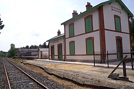
 The Lambel - Camors railway station | |
 Coat of arms | |
Location of Camors  | |
 Camors  Camors | |
| Coordinates: 47°50′55″N 2°59′59″W | |
| Country | France |
| Region | Brittany |
| Department | Morbihan |
| Arrondissement | Lorient |
| Canton | Pluvigner |
| Intercommunality | Auray Quiberon Terre Atlantique |
| Government | |
| • Mayor (2020–2026) | Claude Jarno[1] |
| Area 1 | 37.09 km2 (14.32 sq mi) |
| Population | 3,066 |
| • Density | 83/km2 (210/sq mi) |
| Time zone | UTC+01:00 (CET) |
| • Summer (DST) | UTC+02:00 (CEST) |
| INSEE/Postal code | 56031 /56330 |
| Elevation | 27–137 m (89–449 ft) |
| 1 French Land Register data, which excludes lakes, ponds, glaciers > 1 km2 (0.386 sq mi or 247 acres) and river estuaries. | |
Geography
The village is situated in the heart of a forest-covered region named the Landes de Lanvaux. The village centre is located 24 km (15 mi) south of Pontivy, 28 km (17 mi) northwest of Vannes, and 29 km (18 mi) northeast of Lorient. With the River Tarun, its main tributary, the Ével forms the commune's northern border. The village centre is surrounded by the forest of Floranges and the national forest of Camors. Apart from the village centre, there are the village of Lambel-Camors and the village of Locoal-Camors and several hamlets.
Demographics
Inhabitants of Camors are called in French Camoriens.
|
| ||||||||||||||||||||||||||||||||||||||||||||||||||||||||||||||||||||||||||||||||||||||||||||||||||||||||||||||||||
| Source: EHESS[4] and INSEE (1968-2019)[5] | |||||||||||||||||||||||||||||||||||||||||||||||||||||||||||||||||||||||||||||||||||||||||||||||||||||||||||||||||||
Map
History
In the past, the inhabitants lived off the resources of the forest; they were clog makers, charcoal makers, sawyers, woodcutters...The last clogmaker in Morbihan lived in Camors.
Points of interest
- Arboretum de Camors
See also
References
- "Maires du Morbihan" (PDF). Préfecture du Morbihan. 7 July 2020.
- "Populations légales 2019". The National Institute of Statistics and Economic Studies. 29 December 2021.
- INSEE commune file
- Des villages de Cassini aux communes d'aujourd'hui: Commune data sheet Camors, EHESS. (in French)
- , INSEE
External links
- Official site (in French)
- Base Mérimée: Search for heritage in the commune, Ministère français de la Culture. (in French)
- Mayors of Morbihan Association (in French)
На других языках
[de] Camors
Camors ist eine französische Gemeinde mit 3066 Einwohnern (Stand 1. Januar 2019) im Département Morbihan in der Region Bretagne. Sie gehört zum Arrondissement Lorient sowie zum Kanton Pluvigner.- [en] Camors
[fr] Camors
Camors [kamɔʁ] est une commune française, située dans le département du Morbihan en région Bretagne.Другой контент может иметь иную лицензию. Перед использованием материалов сайта WikiSort.org внимательно изучите правила лицензирования конкретных элементов наполнения сайта.
WikiSort.org - проект по пересортировке и дополнению контента Википедии
