world.wikisort.org - France
Plouay (French pronunciation: [pluɛ]; Breton: Ploue) is a commune in the Morbihan department in Brittany in north-western France.[3]
Plouay
Ploue | |
|---|---|
Commune | |
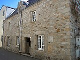
 The town hall in Plouay | |
 Coat of arms | |
Location of Plouay  | |
 Plouay  Plouay | |
| Coordinates: 47°54′56″N 3°20′02″W | |
| Country | France |
| Region | Brittany |
| Department | Morbihan |
| Arrondissement | Lorient |
| Canton | Guidel |
| Intercommunality | Lorient Agglomération |
| Government | |
| • Mayor (2020–2026) | Gwenn Le Nay[1] |
| Area 1 | 67.33 km2 (26.00 sq mi) |
| Population | 5,792 |
| • Density | 86/km2 (220/sq mi) |
| Time zone | UTC+01:00 (CET) |
| • Summer (DST) | UTC+02:00 (CEST) |
| INSEE/Postal code | 56166 /56240 |
| Elevation | 13–164 m (43–538 ft) (avg. 83 m or 272 ft) |
| 1 French Land Register data, which excludes lakes, ponds, glaciers > 1 km2 (0.386 sq mi or 247 acres) and river estuaries. | |
Plouay hosts the GP Ouest-France and the GP de Plouay, annual cycling races (a men's and women's race, respectively). It was also the location of the UCI Road World Championships in 2000. The Tour de France has visited this town three times: in 1998, 2002 and in 2006.
Population
Inhabitants of Plouay or Ploue are called Plouaysiens in French and Plouead (Ploueiz), Ploueadez (-ed) in Breton.[4]
|
| ||||||||||||||||||||||||||||||||||||||||||||||||||||||||||||||||||||||||||||||||||||||||||||||||||||||||||||||||||
| Source: EHESS[5] and INSEE (1968-2019)[6] | |||||||||||||||||||||||||||||||||||||||||||||||||||||||||||||||||||||||||||||||||||||||||||||||||||||||||||||||||||
Geography
Plouay is located in the west of Morbihan, 13 km (8.1 mi) northwest of Hennebont and 18.5 km (11.5 mi) north of Lorient. Historically, it belongs to Vannetais. The river Scorff forms the commune's western border. The area is hilly and forest-covered. Apart from the village centre, there are many hamlets in the commune.
Map

List of places
|
|
|
|
|
History
The oldest surviving parish registers date back to 1576. The marquis of Pontcallec had in the seventeenth century in the village of Plouay court, prison, pillory and gallows with four pillars.
Breton language
The municipality launched a linguistic plan through Ya d'ar brezhoneg on 10 February 2006.
In 2008, 11.56% of the children in Plouay attended Breton-French bilingual classes in primary education.[7]
Gallery
 The Marquis's house, maybe the oldest house in the village centre.
 Manehouarn castle.
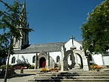 The church of Saint-Ouen.
 The chapel of Notre-Dame des Grâces.
 The chapel of Notre-Dame des Fleurs.


Twin towns
Plouay is twinned with Pershore in England.
See also
References
- "Maires du Morbihan" (PDF). Préfecture du Morbihan. 7 July 2020.
- "Populations légales 2019". The National Institute of Statistics and Economic Studies. 29 December 2021.
- INSEE commune file
- Portail géographique de la Bretagne Archived 2011-06-09 at the Wayback Machine - in French and Breton (accessed 29 July 2010).
- Des villages de Cassini aux communes d'aujourd'hui: Commune data sheet Plouay, EHESS. (in French)
- , INSEE
- (in French) Ofis ar Brezhoneg: Enseignement bilingue
External links
- Cultural Heritage (in French)
- Map showing location of Ploue in Breton
- Mayors of Morbihan Association (in French)
This Morbihan geographical article is a stub. You can help Wikipedia by expanding it. |
На других языках
[de] Plouay
Plouay ist eine französische Gemeinde mit 5.792 Einwohnern (Stand 1. Januar 2019) im Département Morbihan in der Region Bretagne. Sie gehört zum Kanton Guidel im Arrondissement Lorient. Partnergemeinde in Deutschland ist Küps.- [en] Plouay
[fr] Plouay
Plouay [pluɛ] est une commune française située dans le département du Morbihan, en région Bretagne. Historiquement, elle fait partie du Kemenet-Héboé et du Pays de Lorient.[ru] Плуэ
Плуэ (фр. Plouay, [pluɛ]) — коммуна на северо-западе Франции, находится в регионе Бретань, департамент Морбиан, округ Лорьян, кантон Гидель. Расположена в 25 км к северу от Лорьяна, в 15 км от национальной автомагистрали N165.Другой контент может иметь иную лицензию. Перед использованием материалов сайта WikiSort.org внимательно изучите правила лицензирования конкретных элементов наполнения сайта.
WikiSort.org - проект по пересортировке и дополнению контента Википедии