world.wikisort.org - Canada
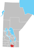
Stanley is a rural municipality (RM) in the province of Manitoba in Western Canada. It is located in the southern part of the province, along its border with the state of North Dakota in the United States. Since 1876, the area made up part of the Mennonite West Reserve. The municipality has a population of 8,969 as of the 2016 Canada Census.[1] The cities of Winkler and Morden lie geographically within the municipality but are separate urban municipalities.
Rural Municipality of Stanley | |
|---|---|
Rural municipality | |
 Rural Municipality of Stanley Location of the Rural Municipality of Stanley | |
| Coordinates: 49°07′59″N 98°03′56″W | |
| Country | Canada |
| Province | Manitoba |
| Region | Pembina Valley |
| Established | 1890 |
| Government | |
| • Reeve | Ike Friesen |
| • Governing Body | RM of Stanley Council |
| • MP (Portage-Lisgar) | Candice Bergen (CPC) |
| • MLA (Borderland) | Josh Guenter (PC) |
| Area | |
| • Total | 835.18 km2 (322.46 sq mi) |
| Population (2021) | |
| • Total | 8,981 |
| Time zone | UTC-6 (CST) |
| • Summer (DST) | UTC-5 (CDT) |
| Website | https://rmofstanley.ca |
Etymology
The municipality is named for The Lord Stanley of Preston, 16th Earl of Derby, Governor General of Canada from 1888 to 1893, namesake for the Stanley Cup, which he donated.
Geography
According to Statistics Canada, the RM has an area of 835.59 km2 (322.62 sq mi). This does not include the areas belonging to the cities of Winkler and Morden, which are surrounded by the RM, in its north-eastern and northern sections, respectively.
Communities
- Blumenfeld
- Chortitz
- Friedensfeld
- Friedensruh
- Haskett
- Hochfeld
- Reinfeld
- Reinland
- Schanzenfeld
- Thornhill
- Neuenburg
Adjacent rural municipalities and counties
- Municipality of Pembina - (west)
- Rural Municipality of Thompson - (northwest)
- Rural Municipality of Roland - (northeast)
- Municipality of Rhineland - (east)
- Pembina County, North Dakota - (southeast)
- Cavalier County, North Dakota - (south)
Demographics
In the 2021 Census of Population conducted by Statistics Canada, Stanley had a population of 8,981 living in 2,279 of its 2,354 total private dwellings, a change of 0.1% from its 2016 population of 8,969. With a land area of 835.18 km2 (322.46 sq mi), it had a population density of 10.8/km2 (27.9/sq mi) in 2021.[2]
|
| |||||||||||||||||||||||||||||||||||||||||||||||||||||||||||||||||||||
See also
- Walhalla–Winkler Border Crossing
External links
ReferencesBa
- "Population and dwelling count amendments, 2016 Census". Statistics Canada. Retrieved 25 July 2021.
- "Population and dwelling counts: Canada, provinces and territories, and census subdivisions (municipalities), Manitoba". Statistics Canada. February 9, 2022. Retrieved February 20, 2022.
- Goldsborough, Gordon (June 15, 2022). "Manitoba Communities: Stanley(Rural Municipality)". Manitoba Historical Society. Retrieved July 20, 2022.
На других языках
- [en] Rural Municipality of Stanley
[ru] Стэнли (сельский муниципалитет, Манитоба)
Стэнли (англ. Stanley) — сельский муниципалитет в области Пембина-Вэлли в южной части провинции Манитоба в Канаде. Площадь — 835,59 км². Население — 8356 человека. Внутри территории муниципалитета располагаются города Винклер и Морден. На юге граничит с штатом Северная Дакота, США.Другой контент может иметь иную лицензию. Перед использованием материалов сайта WikiSort.org внимательно изучите правила лицензирования конкретных элементов наполнения сайта.
WikiSort.org - проект по пересортировке и дополнению контента Википедии
