world.wikisort.org - Canada
Riverton is an unincorporated urban community in the Municipality of Bifrost – Riverton within the Canadian province of Manitoba that held village status prior to January 1, 2015. It is located approximately 110 kilometres north of Winnipeg. The CPR's train conductor is reputed to have named the community.
Riverton | |
|---|---|
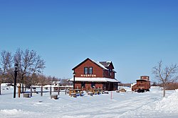
 Riverton Transportation and Heritage Museum in winter. | |
 Riverton Location of Riverton in Manitoba | |
| Coordinates: 50°59′45″N 96°59′55″W | |
| Country | Canada |
| Province | Manitoba |
| Region | Interlake |
| Rural Municipality | Municipality of Bifrost – Riverton |
| Government | |
| • MP (Provencher) | James Bezan (CPC) |
| • MLA (Interlake-Gimli) | Derek Johnson (PC) |
| Elevation | 218 m (715 ft) |
| Time zone | UTC-6 (CST) |
| • Summer (DST) | UTC-5 (CDT) |
| Postal code span | R0C 0A8 |
| Area code | 204 |
Riverton is a descriptive which replaced the earlier name, Icelandic River.[1] Icelandic River was named in 1875 by an Icelandic expedition as a prelude to Riverton. Originally known as White River, it appears on Arrowsmith's map of 1821, and as White Mud on Palliser's map of 1865.[2]
The main economy is fishing. The Freshwater Fish Marketing Corporation operates a fish-packing factory on the banks of the Icelandic River, which passes through the centre of Riverton. Other industries include agriculture and the service sector, with manufacturing being done by ECB (Erosion Control Blanket) a distant third. Being in a unique position on the west shore of Lake Winnipeg, Riverton services the northern communities via a winter road. It is on the way to Hecla-Grindstone Provincial Park and many people from Winnipeg stop in or pass by the community on the way to cottage country each summer.
Demographics
In the 2021 Census of Population conducted by Statistics Canada, Riverton had a population of 475 living in 215 of its 254 total private dwellings, a change of -11.7% from its 2016 population of 538. With a land area of 1.19 km2 (0.46 sq mi), it had a population density of 399.2/km2 (1,033.8/sq mi) in 2021.[3]
Education
- Riverton Collegiate Institute
- Riverton Early Middle School
Notable people
- Reggie Leach, former professional ice hockey player
- Gunnar Thorvaldson, Conservative senator, Senate of Canada.
Solar eclipse
Riverton was the closest community to the point of maximum totality for the solar eclipse of February 26, 1979. This total solar eclipse was part of Saros cycle 120, Series 59. Riverton hosted astronomers and eclipse chasers from across the world, providing free rooms to many of the visitors.
References
- Hamilton, William (1978). The Macmillan Book of Canadian Place Names. Toronto: Macmillan. p. 63. ISBN 0-7715-9754-1.
- Hamilton, William (1978). The Macmillan Book of Canadian Place Names. Toronto: Macmillan. p. 59. ISBN 0-7715-9754-1.
- "Population and dwelling counts: Canada and designated places". Statistics Canada. February 9, 2022. Retrieved Sep 3, 2022.
External links
Другой контент может иметь иную лицензию. Перед использованием материалов сайта WikiSort.org внимательно изучите правила лицензирования конкретных элементов наполнения сайта.
WikiSort.org - проект по пересортировке и дополнению контента Википедии
