world.wikisort.org - Canada
Mystery Lake is a local government district (LGD) in northern Manitoba. It surrounds the city of Thompson, although most of its territory lies to the southwest and south of the city. It is named after Mystery Lake, a lake located in the northeast section of the LGD, northeast of Thompson.
Mystery Lake | |
|---|---|
Local government district | |
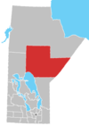
 Mystery Lake Location of Mystery Lake in Manitoba | |
| Coordinates: 55°33′N 98°00′W | |
| Country | Canada |
| Province | Manitoba |
| Region | NorMan |
| Census division | No. 22 |
| Established | December 5, 1956[1] |
| Government | |
| • (Thompson) | Steve Ashton (NDP) |
| • MP (Churchill) | Niki Ashton (NDP) |
| Area | |
| • Land | 3,460.46 km2 (1,336.09 sq mi) |
| Population (2016)[2] | |
| • Total | 0 |
| • Density | 0.0/km2 (0/sq mi) |
| Time zone | UTC−6 (CST) |
| • Summer (DST) | UTC−5 (CDT) |
| Postal code | R8N |
| Area code(s) | 204 |
| Highways | PR 280 |
Communities
- Moak Lake
Demographics
In the 2021 Census of Population conducted by Statistics Canada, Mystery Lake had a population of 0 living in 0 of its 0 total private dwellings, no change from its 2016 population of 0. With a land area of 3,351.37 km2 (1,293.97 sq mi), it had a population density of 0.0/km2 (0.0/sq mi) in 2021.[3]
References
- "Manitoba Communities: Mystery Lake (Local Government District)". Manitoba Historical Society. Retrieved 28 August 2021.
{{cite web}}: CS1 maint: url-status (link) - "Census Profile, 2016 Census Mystery Lake, Local government district [Census subdivision], Manitoba and Manitoba [Province]". Statistics Canada. Retrieved 28 August 2021.
{{cite web}}: CS1 maint: url-status (link) - "Population and dwelling counts: Canada, provinces and territories, and census subdivisions (municipalities), Manitoba". Statistics Canada. February 9, 2022. Retrieved February 20, 2022.
External links
Division No. 22, Manitoba (Thompson and North Central) | ||
|---|---|---|
| Cities |
|  |
| Local government districts | ||
| First Nations |
| |
| Indian reserves |
| |
| Indian settlements |
| |
| Unorganized areas |
| |
| Unincorporated communities |
| |
| ||
This Manitoba location article is a stub. You can help Wikipedia by expanding it. |
Текст в блоке "Читать" взят с сайта "Википедия" и доступен по лицензии Creative Commons Attribution-ShareAlike; в отдельных случаях могут действовать дополнительные условия.
Другой контент может иметь иную лицензию. Перед использованием материалов сайта WikiSort.org внимательно изучите правила лицензирования конкретных элементов наполнения сайта.
Другой контент может иметь иную лицензию. Перед использованием материалов сайта WikiSort.org внимательно изучите правила лицензирования конкретных элементов наполнения сайта.
2019-2026
WikiSort.org - проект по пересортировке и дополнению контента Википедии
WikiSort.org - проект по пересортировке и дополнению контента Википедии