world.wikisort.org - Canada
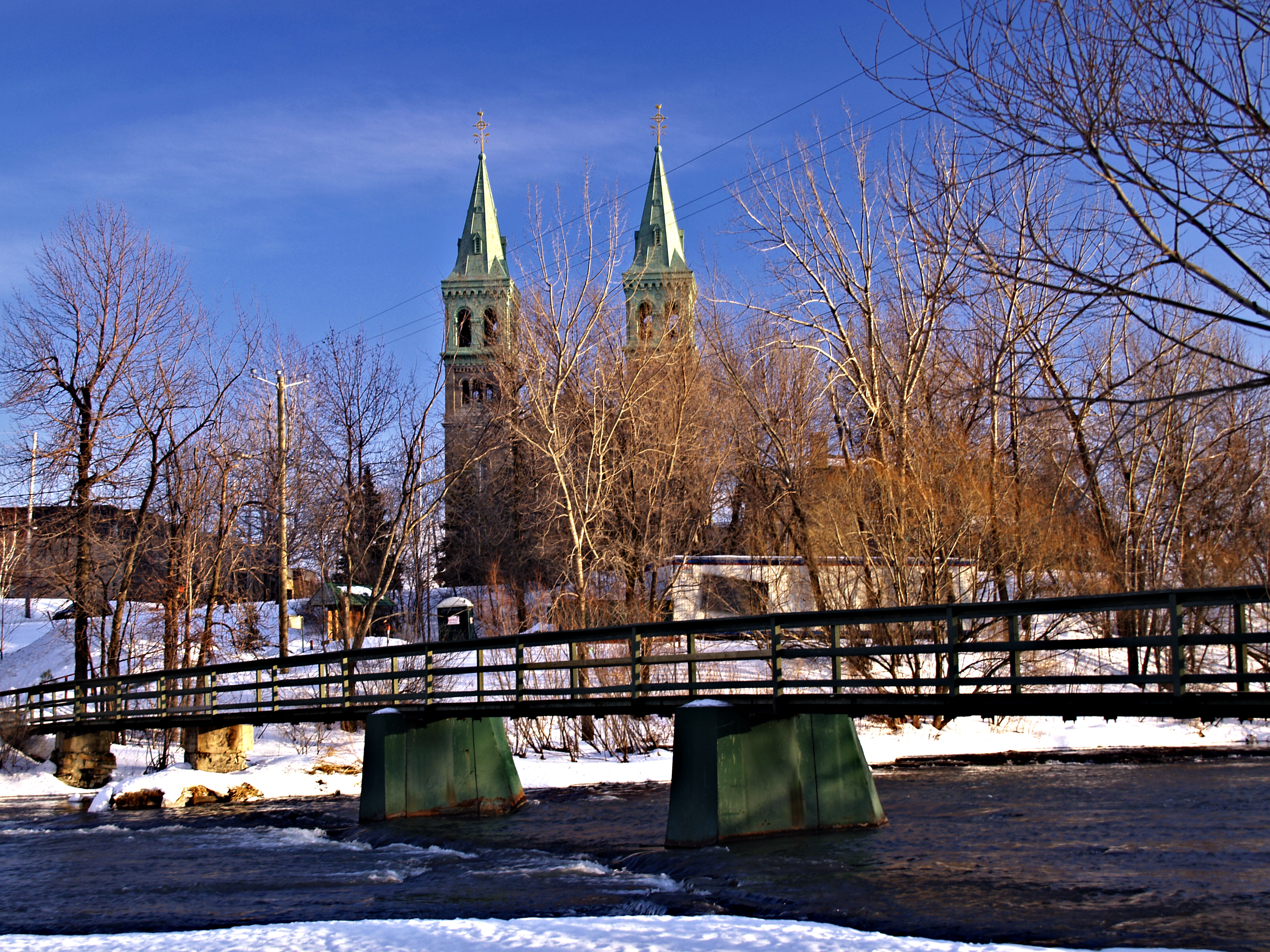
Beauharnois (/boʊˈhɑːrnwɑː/)[5] is a city located in the Beauharnois-Salaberry Regional County Municipality of southwestern Quebec, Canada, and is part of the Greater Montreal Area. The city's population as of the Canada 2011 Census was 12,011. It is home to the Beauharnois Hydroelectric Power Station, as well as the Beauharnois Lock of the Saint Lawrence Seaway.
Beauharnois | |
|---|---|
City | |
 | |
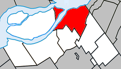 Location within Beauharnois-Salaberry RCM | |
 Beauharnois Location in southern Quebec | |
| Coordinates: 45°19′N 73°52′W[1] | |
| Country | |
| Province | |
| Region | Montérégie |
| RCM | Beauharnois-Salaberry |
| Constituted | January 1, 2002 |
| Government | |
| • Mayor | Alain Dubuc |
| • Federal riding | Salaberry—Suroît |
| • Prov. riding | Beauharnois |
| Area | |
| • Total | 83.70 km2 (32.32 sq mi) |
| • Land | 69.09 km2 (26.68 sq mi) |
| Population (2011)[4] | |
| • Total | 12,011 |
| • Density | 173.9/km2 (450/sq mi) |
| • Pop 2006-2011 | |
| • Dwellings | 5,585 |
| Time zone | UTC−5 (EST) |
| • Summer (DST) | UTC−4 (EDT) |
| Postal code(s) | J6N |
| Area codes | 450 and 579 |
| Highways | |
| Website | ville |
History
This section does not cite any sources. (December 2017) |
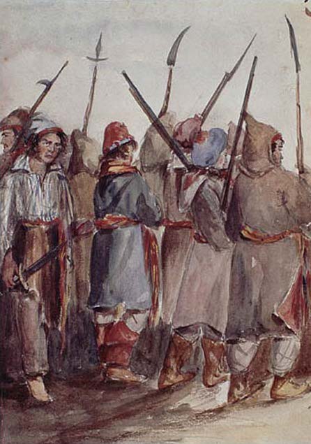
The Battle of Beauharnois was fought at Beauharnois in 1838, between Lower Canada loyalists and Patriote rebels.
As part of the 2000–2006 municipal reorganization in Quebec, the neighbouring towns of Maple Grove and Melocheville were amalgamated into Beauharnois on January 1, 2002.
Geography
Communities
The following locations reside within the municipality's boundaries:[1]
- Domaine-de-la-Pointe-des-Érables (45°19′29″N 73°51′11″W) – a residential area north of Maple Grove
- Maple Grove (45°19′15″N 73°50′20″W) – a former municipality that makes up the northeast boundary of Beauharnois
- Melocheville (45°19′02″N 73°56′15″W) – a former municipality that makes up the western boundary of Beauharnois, located on the west shore of the Beauharnois Canal
- Parc-Tisseur (45°17′42″N 73°53′02″W) – a residential area in southern Beauharnois
- Rivière-Nord (45°00′34″N 74°24′04″W) – a hamlet in southern Beauharnois
- Saint-Paul (45°18′33″N 73°53′51″W) – a residential area located on Route 205
Lakes & Rivers
The following waterways pass through or are situated within the municipality's boundaries:[1]
- Rivière Saint-Louis (45°18′55″N 73°52′49″W) – runs south to north through the city centre, down Chute de la Rivière Saint Louis emptying into the Saint Lawrence River.[citation needed]
Demographics
| Year | Pop. | ±% |
|---|---|---|
| 1991 | 6,449 | — |
| 1996 | 6,435 | −0.2% |
| 2001 | 6,387 | −0.7% |
| 2002+ | 11,454 | +79.3% |
| 2006 | 11,918 | +4.1% |
| 2011 | 12,011 | +0.8% |
| Amalgamated with Maple Grove and Melocheville on January 1, 2002. | ||
In the 2021 Census of Population conducted by Statistics Canada, Beauharnois had a population of 13,638 living in 6,293 of its 6,451 total private dwellings, a change of 5.9% from its 2016 population of 12,884. With a land area of 68.22 km2 (26.34 sq mi), it had a population density of 199.9/km2 (517.8/sq mi) in 2021.[7]
| 2021 | 2011 | |
|---|---|---|
| Population | 13,638 (+5.9% from 2016) | 12,011 (+0.8% from 2006) |
| Land area | 68.22 km2 (26.34 sq mi) | 69.09 km2 (26.68 sq mi) |
| Population density | 199.9/km2 (518/sq mi) | 173.9/km2 (450/sq mi) |
| Median age | 43.2 (M: 42, F: 44.4) | 46.5 (M: 45.8, F: 47.2) |
| Total private dwellings | 6,290 | 5,585 |
| Median household income | $51,185 |
| Canada Census Mother Tongue - Beauharnois, Quebec[6] | ||||||||||||||||||
|---|---|---|---|---|---|---|---|---|---|---|---|---|---|---|---|---|---|---|
| Census | Total | French |
English |
French & English |
Other | |||||||||||||
| Year | Responses | Count | Trend | Pop % | Count | Trend | Pop % | Count | Trend | Pop % | Count | Trend | Pop % | |||||
2016 |
12,670 |
11,865 | 93.65% | 505 | 3.98% | 115 | 0.91% | 185 | 1.46% | |||||||||
2011 |
11,935 |
11,245 | 94.22% | 460 | 3.85% | 105 | 0.88% | 125 | 1.05% | |||||||||
2006 |
11,695 |
11,055 | 94.53% | 395 | 3.38% | 45 | 0.38% | 200 | 1.71% | |||||||||
2001 |
6,240 |
5,990 | 95.99% | 150 | 2.40% | 65 | 1.04% | 35 | 0.56% | |||||||||
1996 |
6,265 |
6,055 | n/a | 98.75% | 130 | n/a | 0.69% | 40 | n/a | 0.33% | 40 | n/a | 0.23% | |||||
| Amalgamated with Maple Grove and Melocheville on January 1, 2002 | ||||||||||||||||||
Economy
In 2012, OVH started construction of its first Canadian data centre in Beauharnois, one of the largest in the world.
See also
- List of cities in Quebec
- Beauharnois Canal
References
- "Reference number 133648 in Banque de noms de lieux du Québec". toponymie.gouv.qc.ca (in French). Commission de toponymie du Québec.
- "Ministère des Affaires municipales, des Régions et de l'Occupation du territoire: Beauharnois". Archived from the original on 2013-02-14. Retrieved 2012-03-11.
- Riding history for Beauharnois—Salaberry, Quebec from the Library of Parliament
- 2011 Statistics Canada Census Profile: Beauharnois, Quebec
- The Canadian Press (2017), The Canadian Press Stylebook (18th ed.), Toronto: The Canadian Press
- Statistics Canada: 1996, 2001, 2006, 2011 census
- "Population and dwelling counts: Canada, provinces and territories, and census subdivisions (municipalities), Quebec". Statistics Canada. February 9, 2022. Retrieved August 29, 2022.
- "2021 Community Profiles". 2021 Canadian Census. Statistics Canada. February 4, 2022. Retrieved 2022-04-27.
- "2011 Community Profiles". 2011 Canadian Census. Statistics Canada. March 21, 2019. Retrieved 2014-01-29.
- "2006 Community Profiles". 2006 Canadian Census. Statistics Canada. August 20, 2019.
- "2001 Community Profiles". 2001 Canadian Census. Statistics Canada. July 18, 2021.
External links
Adjacent Municipal Subdivisions | |
|---|---|
| Cities | |
|---|---|
| Municipalities | |
| Parish Municipalities |
|
| |
Authority control | |
|---|---|
| General | |
| National libraries | |
| Other |
|
На других языках
[de] Beauharnois (Québec)
Beauharnois ist eine Stadt mit 12.884 Einwohnern in der kanadischen Provinz Québec. Sie liegt in der regionalen Grafschaftsgemeinde Beauharnois-Salaberry in Montérégie.- [en] Beauharnois, Quebec
Другой контент может иметь иную лицензию. Перед использованием материалов сайта WikiSort.org внимательно изучите правила лицензирования конкретных элементов наполнения сайта.
WikiSort.org - проект по пересортировке и дополнению контента Википедии