world.wikisort.org - Canada
Saint-Colomban (French pronunciation: [sɛ̃ kɔlɔ̃bɑ̃] (![]() listen)) is a city in the regional county municipality of La Rivière-du-Nord in Québec, Canada. It is situated in the Laurentides region of Québec and was named in honour of Saint Columbanus.
listen)) is a city in the regional county municipality of La Rivière-du-Nord in Québec, Canada. It is situated in the Laurentides region of Québec and was named in honour of Saint Columbanus.
Saint-Colomban | |
|---|---|
City | |
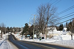
 Saint-Colomban in winter | |
 Logo | |
 Location within La Rivière-du-Nord RCM | |
 St-Colomban Location in central Quebec | |
| Coordinates: 45°44′N 74°08′W[1] | |
| Country | |
| Province | |
| Region | Laurentides |
| RCM | La Rivière-du-Nord |
| Constituted | July 1, 1855 |
| Government | |
| • Mayor | Xavier-Antoine Lalande |
| • Federal riding | Mirabel |
| • Prov. riding | Argenteuil |
| Area | |
| • Total | 94.00 km2 (36.29 sq mi) |
| • Land | 92.71 km2 (35.80 sq mi) |
| Population (2021)[3] | |
| • Total | 17,740 |
| • Density | 191.4/km2 (496/sq mi) |
| • Pop 2016–2021 | |
| Time zone | UTC−5 (EST) |
| • Summer (DST) | UTC−4 (EDT) |
| Postal code(s) | J5K 1A1 |
| Area code(s) | 450 and 579 |
| Highways | No major routes |
| Website | www |
The pioneer responsible for developing the village was the priest John Falvey, who constructed the parish and preached to the first parishioners.
Saint-Colomban was also the birthplace of Mr. Justice Emmett Hall, a justice of the Supreme Court of Canada widely considered to be one of the fathers of Medicare.

Demographics
In the 2021 Census of Population conducted by Statistics Canada, Saint-Colomban had a population of 17,740 living in 6,632 of its 6,807 total private dwellings, a change of 10.7% from its 2016 population of 16,019. With a land area of 92.71 km2 (35.80 sq mi), it had a population density of 191.3/km2 (495.6/sq mi) in 2021.[4]
Education
The Commission scolaire de la Rivière-du-Nord operates French-language public schools.[5]
- École à l'Orée-des-Bois
- École de la Volière
- École des Hautbois
- École Mer-et-Monde
- The primary schools Bellefeuille and Prévost in Saint-Jérôme serve other sections
- École secondaire Émilien-Frenette and École polyvalente Saint-Jérôme, both in Saint-Jérôme
The Sir Wilfrid Laurier School Board operates English-language public schools:
Sources
- "Reference number 403498 in Banque de noms de lieux du Québec". toponymie.gouv.qc.ca (in French). Commission de toponymie du Québec.
- "Geographic code 75005 in the official Répertoire des municipalités". www.mamh.gouv.qc.ca (in French). Ministère des Affaires municipales et de l'Habitation.
- "Tableau des données, Profil du recensement, Recensement de la population de 2021". 9 February 2022.
- "Population and dwelling counts: Canada, provinces and territories, and census subdivisions (municipalities), Quebec". Statistics Canada. February 9, 2022. Retrieved August 29, 2022.
- "Trouver une école ou un centre." Commission scolaire de la Rivière-du-Nord. Retrieved on September 24, 2017. For attendance boundary information, click "Par bassin d'école"
- "LAURENTIAN ELEMENTARY ZONE." Sir Wilfrid Laurier School Board. Retrieved on September 16, 2017.
- "LAURENTIAN REGIONAL HS ZONE." Sir Wilfrid Laurier School Board. Retrieved on September 4, 2017.
- (in French) Répertoire des municipalités du Québec
- (in French) Commission de toponymie du Québec
- (in French) Affaires municipales et régions - cartes régionales
External links
 Media related to Saint-Colomban, Quebec at Wikimedia Commons
- (in French) Site officiel Saint-Colomban
- (in English) Site dedicated to Irish history of the original settlers
Другой контент может иметь иную лицензию. Перед использованием материалов сайта WikiSort.org внимательно изучите правила лицензирования конкретных элементов наполнения сайта.
WikiSort.org - проект по пересортировке и дополнению контента Википедии