world.wikisort.org - Bangladesh
Sirajganj (Bengali: সিরাজগঞ্জ) is a city in north-western Bangladesh on the right bank of the Jamuna River. It is the administrative headquarters of Sirajganj District, and with a population of 167,200 is the fourteenth most populous city in the country. It is about 110 kilometres (68 mi) north west of the capital, Dhaka. It was once a principal centre of the jute trade.
Sirajganj
সিরাজগঞ্জ | |
|---|---|
City | |
 The Jamuna Bridge | |
 Sirajganj | |
| Coordinates: 24°27′N 89°45′E | |
| Country | |
| Division | Rajshahi Division |
| District | Sirajganj District |
| Establishment | Early 1800s |
| Municipality | 1869 |
| Government | |
| • Type | Municipality |
| • Mayor | Sayed Abdur Rouf Mukta[1] |
| Area | |
| • Total | 28.49 km2 (11.00 sq mi) |
| Elevation | 16 m (52 ft) |
| Population | |
| • Total | 167,200 |
| • Density | 5,900/km2 (15,000/sq mi) |
| Time zone | UTC+6 (BST) |
History
During British rule, Sirajganj was a town in the Pabna District of Eastern Bengal and Assam. Its location on the right bank of the Jamuna River or main stream of the Brahmaputra was a six-hour journey by steamer from the railway terminal at Goalundo. It was the chief river mart for jute in northern Bengal, with several jute presses. The jute mills were closed after the 1897 Assam earthquake. The population according to the 1901 census of India was 23,114.[2]
Demographics
According to the 2011 Bangladesh census, Sirajganj city had 37,442 households and a population of 167,200. The literacy rate (age 7 and over) was 62.2%, compared to the national average of 51.8%.[3][4]
Points of interest
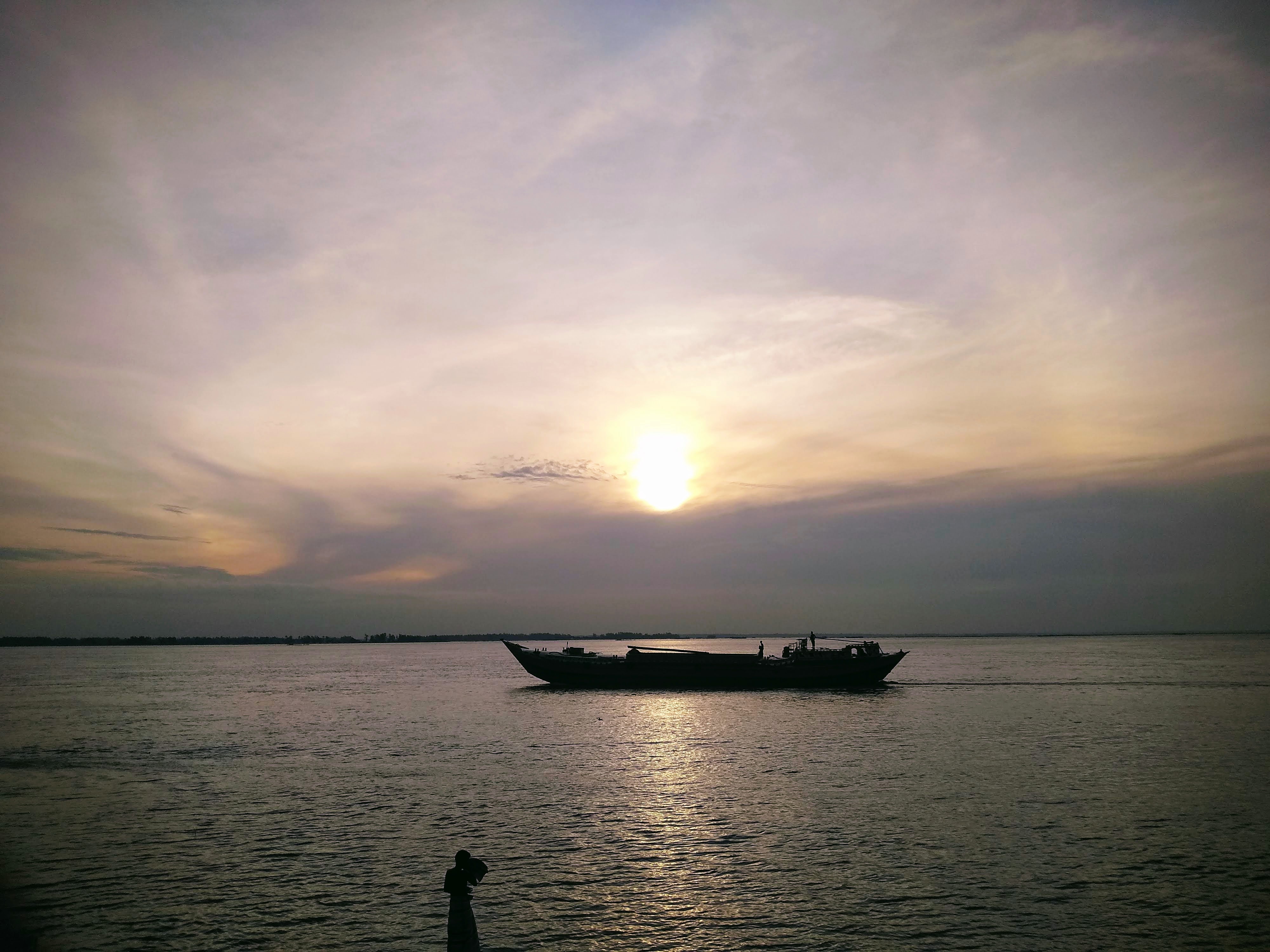

- Jamuna Bridge
- Elliott Bridge
- Sirajganj Hard Point
- Jamuna Eco Park
- Rasel Park
- House of Syed Ismail Hossain Siraji
Transport
In the later half of the 19th century, Sirajganj was an important river port. It was the main collection point for jute produced in northern Bengal and western Mymensingh. After the 1897 Assam earthquake, which damaged infrastructure and shifted the course of the river farther from the city, its significance declined. It was eclipsed by Narayanganj, another river port, which also had a rail connection.[5]
Not until 1915 was Sirajganj connected to the railway network, with the opening of the Sara-Sirajganj line.[5] As of 2022, there is an Intercity train to Dhaka six days a week.[6]
East-west national highway N405 passes just south of the city. It runs east, across the Jamuna Bridge, about 24 kilometres (15 mi) to the Joydebpur–Jamalpur Highway at Elenga, and west about 16 kilometres (9.9 mi) to the Dhaka–Banglabandha Highway.[7]
Education
There are two medical schools in the city, the public Shaheed M. Monsur Ali Medical College, established in 2014, and the private North Bengal Medical College & Hospital, established in 2000. As of May 2019, they are respectively allowed to admit 51 and 85 students annually.[8]
There are eight colleges in the city. They include Sirajganj Government College, founded in 1940, Islamia Government College (1887), and Government Rashidazzoha Womens College.[9][10]
According to Banglapedia, B.L. Government High School, founded in 1869, Jnandayini High School (1884), Saleha Ishaque Government Girls' High School, and Victoria High School (1898) are notable secondary schools.[10]
Notable people
- Jadav Chandra Chakravarti, mathematician, constructed a building in the Dhanbandi neighborhood in 1901.[11]
- Zahid Hasan, actor, was born in Sirajganj in 1967.[12][13]
- Mazharul Islam, poet and folklorist, completed his Higher Secondary Certificate from Sirajganj College in 1947.[14]
- Abdul Latif Mirza, freedom fighter and member of parliament, died in Sirajganj in 2007.[15]
- Ismail Hossain Siraji, poet and novelist, lived in Sirajganj.[16]
- Haimanti Sukla, singer, was born in what is now the Munshi Meherullah Road area of Sirajganj.[11]
References
- সিরাজগঞ্জের তিনটিতে আ.লীগ একটিতে বিদ্রোহী প্রার্থী জয়ী [In Sirajganj, the AL won three, in one the rebel candidate won]. jagonews24.com (in Bengali). 18 January 2021.
- Chisholm, Hugh, ed. (1911). . Encyclopædia Britannica (11th ed.). Cambridge University Press.
- "Population and Housing Census 2011 - Volume 3: Urban Area Report" (PDF). Bangladesh Bureau of Statistics. August 2014. p. 262.
- "Population and Housing Census 2011: Bangladesh at a Glance" (PDF). Bangladesh Bureau of Statistics. Archived from the original (PDF) on 28 July 2014. Retrieved 21 July 2014.
- Ali, Tariq Omar (2018). A Local History of Global Capital: Jute and Peasant Life in the Bengal Delta. Princeton University Press. pp. 69–70, 72. ISBN 978-1-4008-8928-0.
- "Sirajganj Bazar Schedule". Bangladesh Railway.
- "RHD Road Network, Rajshahi Zone". Roads and Highways Department. 2019. Retrieved 29 March 2022.
- "Statistical Year Book Bangladesh 2018" (PDF). Bangladesh Bureau of Statistics. May 2019. pp. 485–486.
- "List of Colleges". Department of Secondary and Higher Education. Retrieved 6 September 2020.
- Islam, Kamrul (2012). "Sirajganj Sadar Upazila". In Islam, Sirajul; Jamal, Ahmed A. (eds.). Banglapedia: National Encyclopedia of Bangladesh (Second ed.). Asiatic Society of Bangladesh.
- ভাষা ও সংস্কৃতি [Language and culture]. Sirajganj District (in Bengali).
- Shazu, Shah Alam (1 December 2010). "'I always work in my own way'". The Daily Star.
- Shazu, Shah Alam (4 October 2017). "Birthday felicitations for Zahid Hasan!". The Daily Star.
- Hossain, Selina; Islam, Nurul; Hossain, Mobarak, eds. (2000). Bangla Academy Dictionary of Writers. Bangla Academy. p. 115. ISBN 984-07-4052-0.
- "Ex-AL lawmaker Mirza Latif passes away". The Daily Star. 7 November 2007.
- Bhattacharya, Sabyasachi (2014). The Defining Moments in Bengal: 1920–1947. Oxford University Press. ISBN 978-0-19-908934-5.
Ismail Husain Siraji of Sirajganj town in Pabna district of East Bengal
External links
Ministry of Public Administration Ministry of Local Government, Rural Development and Co-operatives | ||
| Major cities (11) (City Corporations) |
|  |
| Cities (32) (Municipal Corporations) | ||
| Towns |
| |
This Rajshahi Division location article is a stub. You can help Wikipedia by expanding it. |
На других языках
[de] Sirajganj
Sirajganj (Bengalisch সিরাজগঞ্জ) ist eine Stadt in Bangladesch, die Teil der Division Rajshahi ist. Die Stadt bildet die Hauptstadt des gleichnamigen Distrikt Sirajganj und liegt am Jamuna und westlich des Brahmaputra, etwa 110 km nordwestlich von Dhaka. Die Stadt ist Teil des Upazila Sirajganj Sadar mit 555.155 Einwohnern. Die Einwohnerzahl Sirajganjs lag 2011 bei über 158.000.[1]- [en] Sirajganj
[ru] Сираджгандж
Сираджга́ндж (бенг. সিরাজগঞ্জ) — город и муниципалитет в Бангладеш, административный центр одноимённого округа. Расположен в 110 км к северо-западу от Дакки. Площадь города равна 19,56 км². По данным переписи 2001 года, в городе проживало 127 147 человек, из которых мужчины составляли 50,93 %, женщины — соответственно 49,07 %. Уровень грамотности взрослого населения составлял 48 % (при среднем по Бангладеш показателе 43,1 %).Другой контент может иметь иную лицензию. Перед использованием материалов сайта WikiSort.org внимательно изучите правила лицензирования конкретных элементов наполнения сайта.
WikiSort.org - проект по пересортировке и дополнению контента Википедии