world.wikisort.org - Bangladesh
Sarail (Bengali: সরাইল, romanized: Shorail) is an upazila of Brahmanbaria District[1] located in the Chittagong Division and near the Dhaka Division, Bangladesh.
Sarail
সরাইল | |
|---|---|
Upazila | |
 Sarail Location in Bangladesh | |
| Coordinates: 24°7.1′N 91°7.5′E | |
| Country | |
| Division | Chittagong Division |
| District | Brahmanbaria District |
| Area | |
| • Total | 239.52 km2 (92.48 sq mi) |
| Population (2011) | |
| • Total | 315.208 |
| Time zone | UTC+6 (BST) |
| Postal code | 3430 |
| Website | Official Website of Sarail |
History


The leader of the Baro-Bhuiyan zamindars, Isa Khan, had his first and temporary capital situated in Sarail.[2] During the Mughal era, Sarail was a mahallah (district) of the Sylhet Sarkar.[3]
During the dewani of Shahbaz Khan in 1650, the Hatirpul was constructed. It was a bridge built over the canal mainly for elephant pass. The Mughal dewans used to communicate by the elephant in this road and also took rest near this bridge. In 1662, the Arifil Mosque was constructed by Shah Arif. There are unknown tombs located near the mosque, supposedly belonging to the wives of Isa Khan.
During the Bangladesh Liberation War of 1971, the Pakistani Army killed about 70 innocent people in the Bitghar area. On 5 May, the freedom fighters raided the Pakistani Army's camp in the Shahbazpur area and killed 9 Pakistani soldiers; one freedom fighter was killed during this raid. A number of Pakistani Army officers and the chairman of the Sarail Peace Committee were also killed. The freedom fighters set up a mine bomb north of Kalikaccha Bazar. This exploded and destroyed two military vehicles. Three mass graves remain in Sarail. Memorial monuments were established in the upazila's Bitghar area, the Annada Government High School, the Sarail Degree College and also a monument dedicated to the martyr Sheikh Mesbahuddin Saraili.
In 1990, Sarail was made an upazila of Bangladesh.[1]
Geography
Sarail is located at 24.118333°N 91.125°E. It has 43,854 households and a total area of 227.22 km2.[1]
Demographics
According to the 1991 Bangladesh census, Sarail had a population of 254,481. Males constituted 50.32% of the population, and females 49.68%. The population aged 18 or over was 120,249. Sarail had an average literacy rate of 22.6% (7+ years), against the national average of 32.4%.[4]
Administration
Sarail Upazila is divided into nine union parishads: Auraol, Chunta, Kalikachchha, Noagaon, Pakshimul, Panishor, Sarail, Shahbazpur, and Shahjadapur. The union parishads are subdivided into 67 mauzas and 141 villages.[5]
Chairman: Rafiq ad-Din Thakur
Notable residents
- Sheuly Azad, Member of Parliament, lives in West Kuttapara.[6]
- Nurul Amin, Prime Minister Of Pakistan
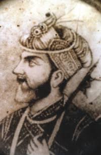
- Isa Khan, a Muslim Rajput zamindar who was one of the Baro Bhuiyans (twelve landlords) and a Zamindar of the Khijirpur in 16th-century Bengal. Throughout his reign he resisted the Mughal empire invasion. It was only after his death that the region fell totally under Mughal control.
See also
- Upazilas of Bangladesh
- Districts of Bangladesh
- Divisions of Bangladesh
References
- Md. Azad Uddin Thakur (2012). "Sarail Upazila". In Islam, Sirajul; Miah, Sajahan; Khanam, Mahfuza; Ahmed, Sabbir (eds.). Banglapedia: the National Encyclopedia of Bangladesh (Online ed.). Dhaka, Bangladesh: Banglapedia Trust, Asiatic Society of Bangladesh. ISBN 984-32-0576-6. OCLC 52727562. Retrieved 24 August 2022.
- AA Sheikh Md Asrarul Hoque Chisti (2012). "Isa Khan". In Islam, Sirajul; Miah, Sajahan; Khanam, Mahfuza; Ahmed, Sabbir (eds.). Banglapedia: the National Encyclopedia of Bangladesh (Online ed.). Dhaka, Bangladesh: Banglapedia Trust, Asiatic Society of Bangladesh. ISBN 984-32-0576-6. OCLC 52727562. Retrieved 24 August 2022.
- Nath, Pratyay (28 Jun 2019). Climate of Conquest: War, Environment, and Empire in Mughal North India. Oxford University Press.
- "Population Census Wing, BBS". Archived from the original on 2005-03-27. Retrieved November 10, 2006.
- "District Statistics 2011: Brahmanbaria" (PDF). Bangladesh Bureau of Statistics. Archived from the original (PDF) on 13 November 2014. Retrieved 14 July 2014.
- "Constituency 312_11th_En". Bangladesh Parliament. Retrieved 11 September 2020.
Brahmanbaria District | ||
|---|---|---|
Capital: Brahmanbaria | ||
| Upazilas |
| |
| Constituencies |
| |
| Attractions and sites |
| |
| History |
| |
| Inhabited areas | ||
| Rivers | ||
| Educational institutions |
| |
| Organisations |
| |
| Transport |
| |
| See also |
| |
Capital: Chattogram | ||
| Bandarban District |
|  |
| Brahmanbaria District |
| |
| Chandpur District | ||
| Chattogram District | ||
| Cumilla District |
| |
| Cox's Bazar District |
| |
| Feni District |
| |
| Khagrachari District |
| |
| Lakshmipur District |
| |
| Noakhali District |
| |
| Rangamati District |
| |
This Chittagong Division location article is a stub. You can help Wikipedia by expanding it. |
На других языках
- [en] Sarail Upazila
[ru] Сарайл
Сарайл (бенг. সরাইল, англ. Sarail) — город на востоке Бангладеш, административный центр одноимённого подокруга. Площадь города равна 14,03 км². По данным переписи 2001 года, в городе проживало 34 950 человек, из которых мужчины составляли 48,91 %, женщины — соответственно 51,09 %. Плотность населения равнялась 2491 чел. на 1 км².Другой контент может иметь иную лицензию. Перед использованием материалов сайта WikiSort.org внимательно изучите правила лицензирования конкретных элементов наполнения сайта.
WikiSort.org - проект по пересортировке и дополнению контента Википедии