world.wikisort.org - Bangladesh
Rangamati (Bengali: রাঙ্গামাটি; Chakma:𑄢𑄋𑄟𑄖𑄴𑄳𑄠 ) is the administrative headquarter and town of Rangamati Hill District in the Chittagong Hill Tracts of Bangladesh. The town is located at 22°37'60N 92°12'0E and has an altitude of 14 metres (46 ft).[1] The district is administered by an office named as District Administration, Rangamati.
Rangamati
রাঙ্গামাটি 𑄢𑄋𑄟𑄖𑄴𑄳𑄠 | |
|---|---|
Town | |
 | |
| Nickname: Lake City of Bangladesh | |
 Rangamati Location in Chittagong Division  Rangamati Location in Bangladesh | |
| Coordinates: 22°38′N 92°12′E | |
| Country | |
| Division | Chittagong Division |
| District | Rangamati District |
| Government | |
| • Incumbent MP | Dipankar Talukdar |
| • Mayor | Akbar Hossain Chowdhury |
| • Rulling Party | Awami League |
| Area | |
| • Total | 21 km2 (8 sq mi) |
| Elevation | 14 m (49 ft) |
| Population (2011) | |
| • Total | 66,836 |
| Time zone | UTC+6 (BST) |
| Postal Code | 4500 |
| Area code | 0351 |
| Climate | Am |
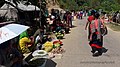
From Chittagong a 77 kilometres (48 mi) road leads to Rangamati. The township is located on the western bank of the Kaptai lake. Rangamati is a holiday destination because of its landscape, scenic beauty, lake, indigenous groups (Chakma, Marma, Tripuri, Tanchangya, Pangkhua etc.), flora and fauna, indigenous museum, hanging bridge etc.
Tourist attractions
Rangamati is surrounded by natural features like as mountains, rivers, lakes, and waterfalls. Rangamati is also home to several ethnic groups. Some of the most popular attractions are:
Climate
| Climate data for Rangamati | |||||||||||||
|---|---|---|---|---|---|---|---|---|---|---|---|---|---|
| Month | Jan | Feb | Mar | Apr | May | Jun | Jul | Aug | Sep | Oct | Nov | Dec | Year |
| Average high °C (°F) | 25.7 (78.3) |
28.5 (83.3) |
32.0 (89.6) |
33.0 (91.4) |
32.7 (90.9) |
31.2 (88.2) |
30.5 (86.9) |
31.0 (87.8) |
31.5 (88.7) |
31.4 (88.5) |
29.1 (84.4) |
26.2 (79.2) |
30.2 (86.4) |
| Average low °C (°F) | 14.0 (57.2) |
15.9 (60.6) |
20.0 (68.0) |
22.9 (73.2) |
24.0 (75.2) |
24.9 (76.8) |
24.8 (76.6) |
24.9 (76.8) |
24.8 (76.6) |
23.9 (75.0) |
20.6 (69.1) |
16.0 (60.8) |
21.4 (70.5) |
| Average precipitation mm (inches) | 5.1 (0.20) |
24.3 (0.96) |
62.1 (2.44) |
147.9 (5.82) |
319.7 (12.59) |
504.8 (19.87) |
572.6 (22.54) |
435.2 (17.13) |
259.6 (10.22) |
152.2 (5.99) |
55.7 (2.19) |
9.5 (0.37) |
2,548.7 (100.34) |
| Average precipitation days | 1 | 2 | 3 | 8 | 13 | 18 | 21 | 20 | 15 | 8 | 4 | 1 | 114 |
| Average relative humidity (%) | 77 | 69 | 67 | 72 | 78 | 84 | 85 | 85 | 85 | 84 | 82 | 81 | 79 |
| Source: Bangladesh Meteorological Department[3][4][5][6][7] | |||||||||||||
Gallery
 Rangamati-Kaptai Highway, Rangamati
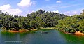 Rangamati, Lake Kaptai
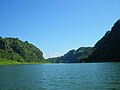
 Lower portion of the Shuvolong Fall
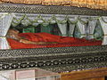 Mummified Body of the Top Mohanto at Rajbana Vihara
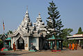 Rajbana Vihara, a renowned Buddhist Temple at Rangamati
 Wild Asian elephant, can be seen in the hilly forests of Rangamati
 Kaptai Lake Barkal Upazila
 Shuvolong waterfall in dry season
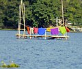 Life in Water
 Hanging bridge Rangamati


References
- Location of Rangamati - Falling Rain Genomics
- "Top Things to Do in Rangamati". Retrieved 31 August 2021.
- "Monthly Maximum Temperature". Bangladesh Meteorological Department. Retrieved January 31, 2016.
- "Monthly Minimum Temperature". Bangladesh Meteorological Department. Retrieved January 31, 2016.
- "Normal Monthly Rainfall". Bangladesh Meteorological Department. Retrieved January 31, 2016.
- "Normal Monthly Rainy Day". Bangladesh Meteorological Department. Retrieved January 31, 2016.
- "Normal Monthly Humidity". Bangladesh Meteorological Department. Retrieved January 31, 2016.
| Upazila/Thana: | ||
|---|---|---|
Authority control | |
|---|---|
| General |
|
| National libraries | |
На других языках
[de] Rangamati
Rangamati (Bengalisch: রাঙ্গামাটি, Rāṅgāmāṭi) ist eine Stadt im südöstlichen Bangladesch mit 65.000 Einwohnern. Sie ist Verwaltungssitz des Distrikts Rangamati und besteht aus 9 Wards (Stadtbezirke). Das Stadtgebiet umfasst eine Fläche von 64,75 km².- [en] Rangamati
[ru] Рангамати
Рангама́ти (бенг. রাঙ্গামাটি) — город и муниципалитет на юго-востоке Бангладеш, административный центр одноимённого округа. Площадь города равна 64,75 км². По данным переписи 2001 года, в городе проживало 65 294 человека, из которых мужчины составляли 57,68 %, женщины — соответственно 42,32 %. Плотность населения равнялась 1008 чел. на 1 км². Уровень грамотности взрослого населения составлял 60,8 % (при среднем по Бангладеш показателе 43,1 %). Рангамати известен как «город озёр» и является популярным туристическим местом.Другой контент может иметь иную лицензию. Перед использованием материалов сайта WikiSort.org внимательно изучите правила лицензирования конкретных элементов наполнения сайта.
WikiSort.org - проект по пересортировке и дополнению контента Википедии