world.wikisort.org - Bangladesh
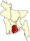
Doshmina (Bengali: দশমিনা) is an upazila of Patuakhali District in the Division of Barisal, Bangladesh.[1] Abdul Mannan Khan .
Doshmina
দশমিনা | |
|---|---|
Upazila | |
 Doshmina Location in Bangladesh | |
| Coordinates: 22°17′N 90°35.4′E | |
| Country | |
| Division | Barisal Division |
| District | Patuakhali District |
| Area | |
| • Total | 351.74 km2 (135.81 sq mi) |
| Population (1991) | |
| • Total | 106,539 |
| • Density | 300/km2 (780/sq mi) |
| Time zone | UTC+6 (BST) |
| Website | Official Map of the Doshmina Upazila |
Geography
Dashmina is located at 22.2833°N 90.5903°E. It has 19,863 households and a total area of 351.74 km2. The Upazila Headquarters is situated in Dashmina Sadar. It is situated on the Bank of the river Tetulia.
Within 6 unions of Dashmina including the Sadar at the centre, two of them are in the north of Dashmina Sadar namely Bashbaria and Bahrampur union. Bashbaria is situated on the bank of the river Tetulia. North Border of both Bahrampur and Bashbaria union ends up with starting of Baufal upazila. Rono Gopaldi and Betagi Shankipur union is situated on the north western part of Dashmina Sadar and finally the Alipura union covers the southern part of this historic Upazila which ends up with starting of Galachipa upazila.
Demographics
According to the 1991 Bangladesh census, Dashmina had a population of 106,539. Males constituted 49.5% of the population, and females 50.5%. The population aged 18 or older was 52,137. Dashmina had an average literacy rate of 29.5% (7+ years), compared to the national average of 32.4%.
Administration
Dashmina Upazila is divided into six union parishads: Alipur, Bahrampur, Banshbaria, Betagi Shankipur, Dashmina, and Rangopaldi. The union parishads are subdivided into 51 mauzas and 55 villages.[2]
Education
At present it holds three colleges, three Boys' high schools, two girls' schools, an Alia Madrasa and a number of government and non government primary schools.
- Abdur Rashid Talukdar Degree
College
- Alipura College
- Doli Akbar Mohila College
- Dashmina Govt. Model High School
- Gachhani Secondary School
- Begum Arefatunnessa Girls High School
- Banglabazar Girls High School
- Hazirhat Nimmo maddhomik
Biddyalaoy
- Dashmina Senior Fazil Madrasha
- BM Labrotary School
- Bahrampur High School
See also
- Upazilas of Bangladesh
- Districts of Bangladesh
- Divisions of Bangladesh
References
- Gazi Shahidul Islam (2012). "Dashmina Upazila". In Sirajul Islam and Ahmed A. Jamal (ed.). Banglapedia: National Encyclopedia of Bangladesh (Second ed.). Asiatic Society of Bangladesh.
- "District Statistics 2011: Patuakhali" (PDF). Bangladesh Bureau of Statistics. Archived from the original (PDF) on 13 November 2014. Retrieved 14 July 2014.
Другой контент может иметь иную лицензию. Перед использованием материалов сайта WikiSort.org внимательно изучите правила лицензирования конкретных элементов наполнения сайта.
WikiSort.org - проект по пересортировке и дополнению контента Википедии
