world.wikisort.org - Bangladesh
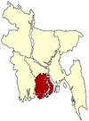
Manpura (Bengali: মনপুরা) is an upazila of Bhola District in the Division of Barisal, Bangladesh.[1]
Manpura
মনপুরা | |
|---|---|
Upazila | |
 Manpura Location in Bangladesh | |
| Coordinates: 22°17.9′N 90°58.8′E | |
| Country | |
| Division | Barisal Division |
| District | Bhola District |
| Government | |
| • Honorable Parliament Member | Abdullah Al-Islam Jakob |
| Area | |
| • Total | 373.19 km2 (144.09 sq mi) |
| Population (2001) | |
| • Total | 67,304 |
| • Density | 180/km2 (470/sq mi) |
| Time zone | UTC+6 (BST) |
| Website | monpura |
Geography

Manpura is located at 22.2986°N 90.9792°E. It has 8,959 households and a total area of 373.19 km2.
Demographics
According to the 2001 Bangladesh census, Manpura had a population of 67,304. Males constituted 51.63% of the population, and females 48.37%. The population aged 18 or over was 20,940. Manpura had an average literacy rate of 21.3% (7+ years), compared to the national average of 50.4%+.[2]
Administration
Manpura Upazila is divided into four union parishads: Dakshin Sakuchia, Hazirhat, Monpura, and Uttar Sakuchia. The union parishads are subdivided into 18 mauzas and 30 villages.[3]
Education
- Sakuchia Badiuzzaman Dakhil Madrasah
- Monpura Degree College
- Monoyara Begum mohila college
- Abdullah al Islam Jakob College
- Monpura Girls' Secondary School
- Hazir Hat Girls School [citation needed]
See also
- Upazilas of Bangladesh
- Districts of Bangladesh
- Divisions of Bangladesh
References
- Zakir Hussain (2012). "Manpura Upazila". In Sirajul Islam and Ahmed A. Jamal (ed.). Banglapedia: National Encyclopedia of Bangladesh (Second ed.). Asiatic Society of Bangladesh.
- "Population Census Wing, BBS". Archived from the original on 2005-03-27. Retrieved November 10, 2006.
- "District Statistics 2011: Bhola" (PDF). Bangladesh Bureau of Statistics. Archived from the original (PDF) on 13 November 2014. Retrieved 14 July 2014.
Текст в блоке "Читать" взят с сайта "Википедия" и доступен по лицензии Creative Commons Attribution-ShareAlike; в отдельных случаях могут действовать дополнительные условия.
Другой контент может иметь иную лицензию. Перед использованием материалов сайта WikiSort.org внимательно изучите правила лицензирования конкретных элементов наполнения сайта.
Другой контент может иметь иную лицензию. Перед использованием материалов сайта WikiSort.org внимательно изучите правила лицензирования конкретных элементов наполнения сайта.
2019-2025
WikiSort.org - проект по пересортировке и дополнению контента Википедии
WikiSort.org - проект по пересортировке и дополнению контента Википедии
