world.wikisort.org - Australia
Wee Jasper is a hamlet in the Goodradigbee valley at the western foot of the Brindabella Ranges, near Burrinjuck Dam in New South Wales, Australia in Yass Valley Shire.[2] It is located about 90 km north-west of Canberra and 60 km south-west of Yass. At the 2021 census, Wee Jasper and the surrounding area had a population of 127.[1]
| Wee Jasper New South Wales | |||||||||||||||
|---|---|---|---|---|---|---|---|---|---|---|---|---|---|---|---|
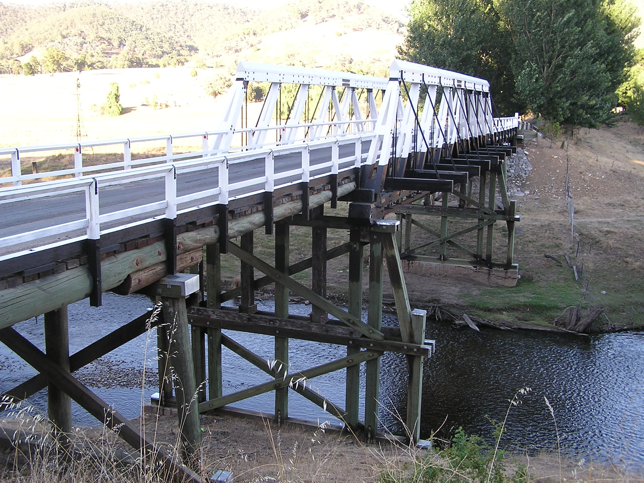 Bridge across Goodradigbee River at Wee Jasper | |||||||||||||||
Wee Jasper | |||||||||||||||
| Coordinates | 35°06′0″S 148°40′0″E | ||||||||||||||
| Population | 127 (2021 census)[1] | ||||||||||||||
| Postcode(s) | 2582 | ||||||||||||||
| Elevation | 376–1,121 m (1,234–3,678 ft) | ||||||||||||||
| Location |
| ||||||||||||||
| LGA(s) | Yass Valley Council | ||||||||||||||
| County | Buccleuch | ||||||||||||||
| State electorate(s) | Goulburn | ||||||||||||||
| Federal division(s) | Eden-Monaro | ||||||||||||||
| |||||||||||||||
| |||||||||||||||
History and description
The place now known as Wee Jasper and the surrounding area of the Goodradigbee River valley lie on the traditional lands of the Ngunnawal people.[3] The area lay outside the Nineteen Counties, in which the colonial government allowed colonial settlement; the County of Buccleuch and the neighbouring County of Cowley were not proclaimed, until 31 December 1848.[4]
The origin of the name Wee Jasper is unknown. It has been in use since at latest 1848, when it appeared as a single-word name 'Weejasper'.[5] Although both 'Weejasper' and 'Wee Jasper' were used subsequently, it was not until 1970 that the village's name changed officially from 'Weejasper' to Wee Jasper.[6] The name is possibly of Aboriginal origin.
The Hume and Hovell expedition passed through the area in October 1824.[7]
Colonial settlement in the area dates from 1831, when a land grant at 'Cooradigbee' was made. It was one of the last free land grants in the colony of New South Wales, and it was only granted because it already had been promised by Governor Darling, in October 1830.[8] On 9 January 1831, Viscount Goderich instructed that no more free grants, except those already promised, be given. All land thereafter was to be sold at public auction.[9] The land grant extinguished what would later—in 1992—become known as native title over the land, effectively dispossessing the traditional owners.
There was a site for a village, to be known as Goodradigbee, proclaimed in 1866, but its design was cancelled in 1900.[10][11][12] The cluster of settlement instead developed, further upstream on the river, nearer to the eventual site of the bridge, at what is now the village of Wee Jasper.[13]
'Coodra Vale', a property close to Wee Jasper of 40,000 acres (16,188 ha), was the home of pastoralist, Stewart Ryrie, Junior, from 1871 until his death in 1882.[14][15] From 1908 to 1912, 'Coodra Vale' was the home of renowned Australian bush-poet, A.B. 'Banjo' Paterson;[16][17][18][19] his poem, A Mountain Station, was informed by the time he spent there as an agriculturalist.[20]
South of the village is the confluence of the Goodradigbee and its tributary, Wee Jasper Creek. Gold was found and mined along this creek, in the 1890s, when it was known as 'The Wee Jasper'.[21][22] The Goodradigbee Goldfield, which included the area, was proclaimed in 1882, but was revoked in 1897.[23] Although mining took place, the area was not a significant mining area.
The bridge across the Goodradigbee River, at Wee Jasper, opened in September 1896, providing a better connection from the area to Yass and Tumut.[24] The filling of the Burrinjuck Dam, during the 1920s, resulted in the inundation of part of the valley, downstream from the village. More land was inundated later, when the dam wall was raised.[25]
Wee Jasper had a police station by 1887.[26] Wee Jasper Post Office was first opened in January 1886 and closed in March 1892. Three years later, it was reopened again and remained in service until 1994.[27] There is a school at Wee Jasper, which opened as a provisional school in 1899 and achieved public school status in 1918.[28] Wee Jasper had a Catholic church, now repurposed.[29]
Near the village are several camping and recreation reserves close to numerous caves. The best known cave is Carey's Cave, a system of seven caverns lying just north of the town.[2] Others lie to the north and south, including Dip, Dogleg, Punch-bowl and Signature Caves.[2]
Fossils, including members of the Acanthothoracid placoderm fish family Weejasperaspididae, the primitive placoderm Brindabellaspis stensioi and the prehistoric lungfish, Dipnorhynchus cathlesae, have been found in the area.[30]
Heritage listings
Wee Jasper has a number of heritage-listed sites, including:
- 278 Main Road: Wee Jasper Bridge over Goodradigbee River[31]
Gallery
 Wee Jasper town sign
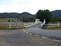 The main bridge spanning the Goodradigbee River going into Wee Jasper


Climate
Wee Jasper has a typical climate of the upper South West Slopes, akin to that of Batlow; comprising warm, stormy summers and cold, very wet winters with frequent and heavy snowfall.
Maximum temperatures are significantly cooler than regions of similar altitude in the Australian Capital Territory, owing to its windward position on the western slopes of the Brindabella Range.
| Climate data for Billapaloola State Forest (1938–1969); 808 m AMSL; 35.27° S, 148.38° E | |||||||||||||
|---|---|---|---|---|---|---|---|---|---|---|---|---|---|
| Month | Jan | Feb | Mar | Apr | May | Jun | Jul | Aug | Sep | Oct | Nov | Dec | Year |
| Average high °C (°F) | 26.6 (79.9) |
25.6 (78.1) |
23.1 (73.6) |
17.1 (62.8) |
12.6 (54.7) |
9.3 (48.7) |
8.4 (47.1) |
9.8 (49.6) |
13.8 (56.8) |
16.6 (61.9) |
20.0 (68.0) |
24.3 (75.7) |
17.3 (63.1) |
| Average low °C (°F) | 12.1 (53.8) |
11.8 (53.2) |
9.8 (49.6) |
5.8 (42.4) |
3.2 (37.8) |
1.2 (34.2) |
0.1 (32.2) |
0.5 (32.9) |
2.4 (36.3) |
4.8 (40.6) |
7.2 (45.0) |
10.0 (50.0) |
5.7 (42.3) |
| Average precipitation mm (inches) | 86.9 (3.42) |
71.4 (2.81) |
98.8 (3.89) |
113.7 (4.48) |
163.4 (6.43) |
156.1 (6.15) |
172.6 (6.80) |
162.9 (6.41) |
132.6 (5.22) |
145.0 (5.71) |
120.1 (4.73) |
86.5 (3.41) |
1,515.4 (59.66) |
| Average precipitation days (≥ 0.2 mm) | 5.8 | 5.6 | 6.1 | 7.9 | 10.9 | 12.3 | 13.4 | 13.6 | 10.3 | 11.1 | 8.7 | 7.0 | 112.7 |
| Source: Australian Bureau of Meteorology; Billapaloola State Forest | |||||||||||||
References
- Australian Bureau of Statistics (28 June 2022). "Wee Jasper". 2021 Census QuickStats. Retrieved 27 September 2022.
- Dow L, Guyon D, Irving R, McPhee M, Matthews A, Prineas P, Rubinich T, Simpson J (1995). Reader's Digest Illustrated Guide to Australian Places. Surry Hills, NSW: Reader's Digest. p. 209. ISBN 0-86438-399-1.
- Studies, Australian Institute of Aboriginal and Torres Strait Islander (5 June 2022). "Map of Indigenous Australia". aiatsis.gov.au. Retrieved 17 May 2022.
- "PROCLAMATION". New South Wales Government Gazette. 30 December 1848. p. 1883. Retrieved 18 May 2022.
- Wells, William Henry (1848). "A geographical dictionary, or, Gazetteer of the Australian colonies : together with a brief notice of all the capitals, principal towns, and villages". trove.nla.gov.au. Retrieved 18 May 2022.
- "GEOGRAPHICAL NAMES ACT, 1966". Government Gazette of the State of New South Wales. 29 May 1970. p. 2043. Retrieved 18 May 2022.
- "From a tiny township, to a booming tourist spot". Canberra Times. 30 December 1993. p. 4. Retrieved 18 May 2022.
- "GRANTS OF LAND". New South Wales Government Gazette. 2 March 1839. p. 275. Retrieved 17 May 2022.
- "Land Grants Guide, 1788-1856". www.records.nsw.gov.au. 16 December 2015. Retrieved 18 May 2022.
- "SITE FOR A VILLAGE". New South Wales Government Gazette. 1 June 1866. p. 1318. Retrieved 18 May 2022.
- "PROPOSED CANCELLATION OF DESIGN OF THE VILLAGE OF GOODRADIGBEE". New South Wales Government Gazette. 2 May 1900. p. 3417. Retrieved 18 May 2022.
- "County of Cowley and Co. Buccleuch New South Wales, 1871 [cartographic material]". Trove. Retrieved 18 May 2022.
- "Wee Jasper - Satellite View". Google Maps. Retrieved 19 May 2022.
- "Pastoral and Agricultural Intelligence, Stock Movements &c". Australian Town and Country Journal. 25 February 1871. p. 6. Retrieved 10 May 2022.
- "Family Notices". Sydney Morning Herald. 10 November 1882. p. 1. Retrieved 9 May 2022.
- "AB 'Banjo' Paterson". Reserve Bank of Australia Banknotes. Retrieved 9 May 2022.
- "Bard of the Bush". Daily Mirror. Truth and Sportsman Ltd. 20 June 1956. p. 21.
- Semmler, Clement, "Paterson, Andrew Barton (Banjo) (1864–1941)", Australian Dictionary of Biography, Canberra: National Centre of Biography, Australian National University, retrieved 10 May 2022
- "Paterson, Andrew Barton b. 17 Feb 1864 "Narrambla", Orange, NSW d. 5 Feb 1941 Sydney, NSW". barton101.com. Retrieved 11 May 2022.
- Station, A. Mountain. "A Mountain Station by A B Banjo Paterson". allpoetry.com. Retrieved 11 May 2022.
- "Wee Jasper and Adginbilly". Sydney Mail and New South Wales Advertiser. 25 August 1894. p. 409. Retrieved 18 May 2022.
- "MINING REPORT". Truth. 26 August 1894. p. 3. Retrieved 18 May 2022.
- "PROCLAMATION". New South Wales Government Gazette. 4 December 1897. p. 8807. Retrieved 18 May 2022.
- "THE LITTLE RIVER BRIDGE". Yass Courier. 8 September 1896. p. 2. Retrieved 18 May 2022.
- "2,000 ACRES OF YASS LAND UNDER WATER". Gundagai Independent. 27 November 1947. p. 4. Retrieved 18 May 2022.
- "THE PREMIER'S ELECTION SPEECHES". Yass Courier. 1 April 1887. p. 2. Retrieved 19 May 2022.
- Phoenix Auctions History. "Post Office List". Retrieved 20 January 2021.
- "Wee Jasper". nswgovschoolhistory.cese.nsw.gov.au. Retrieved 18 May 2022.
- Taulaga, Jessica (11 November 2021). "'A little corner of heaven': Wee Jasper church on the market could be your saving grace". All Homes Real Estate. Retrieved 11 November 2021.
- Campbell, K.S.W.; R.E. Barwick (1999). "A New Species of the Devonian Lungfish Dipnorhynchus from Wee Jasper, New South Wales" (pdf). Records of the Australian Museum 51(2): 123–140. Australian Museum. Retrieved 30 January 2007.
- "Wee Jasper Bridge over Goodradigbee River". New South Wales State Heritage Register. Office of Environment & Heritage. H01485. Retrieved 18 May 2018.
| Towns and residential areas | |
|---|---|
| Localities |
|
Main Article: Local government areas of New South Wales | |
Другой контент может иметь иную лицензию. Перед использованием материалов сайта WikiSort.org внимательно изучите правила лицензирования конкретных элементов наполнения сайта.
WikiSort.org - проект по пересортировке и дополнению контента Википедии