world.wikisort.org - Australia
Springdale is a village community in the central north part of the Riverina region of the Australian state of New South Wales.[2] It is situated by road, about 3 kilometres east of Combaning and 23 kilometres north west of Stockinbingal. At the 2016 census, it had a population of 150.[1]
| Springdale New South Wales | |
|---|---|
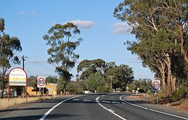
 Entering Springdale | |
 Springdale | |
| Coordinates | 34°27′S 147°43′E |
| Population | 150 (2016 census)[1] |
| Postcode(s) | 2666 |
| Location |
|
| LGA(s) | Temora Shire |
| County | Bland |
| State electorate(s) | Cootamundra |
| Federal division(s) | Riverina |
Springdale Post Office opened on 1 November 1897 and closed in 1977.[3] A railway station on the branch line to Lake Cargelligo served the community between 1893 and 1975.[4]
Gallery
- Springdale Functions Hall
- All Saints Anglican church
- War memorial
Springdale railway station
| Preceding station | Former Services | Following station | ||
|---|---|---|---|---|
| Combaning towards Lake Cargelligo |
Lake Cargelligo Line | Gundibindyal towards Cootamundra | ||
References
- Australian Bureau of Statistics (27 June 2017). "Springdale". 2016 Census QuickStats. Retrieved 3 August 2020.
- "Springdale". Geographical Names Register (GNR) of NSW. Geographical Names Board of New South Wales.
- Phoenix Auctions, Post Office List, retrieved 24 January 2021
- Combaning station. NSWrail.net, accessed 6 September 2009.
| Wikimedia Commons has media related to Springdale, New South Wales. |
Текст в блоке "Читать" взят с сайта "Википедия" и доступен по лицензии Creative Commons Attribution-ShareAlike; в отдельных случаях могут действовать дополнительные условия.
Другой контент может иметь иную лицензию. Перед использованием материалов сайта WikiSort.org внимательно изучите правила лицензирования конкретных элементов наполнения сайта.
Другой контент может иметь иную лицензию. Перед использованием материалов сайта WikiSort.org внимательно изучите правила лицензирования конкретных элементов наполнения сайта.
2019-2025
WikiSort.org - проект по пересортировке и дополнению контента Википедии
WikiSort.org - проект по пересортировке и дополнению контента Википедии


