world.wikisort.org - Australia
Matong /məˈtɒŋ/ is a town in the central east part of the Riverina region of New South Wales, Australia. The town is 37 kilometres (23 mi) east of Narrandera and 26 kilometres (16 mi) west of Coolamon. At the 2016 census, Matong had a population of 164 people.[1]
| Matong New South Wales | |
|---|---|
 The Farmers Home Hotel being rebuilt after a fire | |
Matong | |
| Coordinates | 34°46′0″S 146°55′0″E |
| Population | 164 (2016 census)[1] |
| Postcode(s) | 2652 |
| Elevation | 192 m (630 ft) |
| Location |
|
| LGA(s) | Coolamon Shire |
| County | Bourke |
| State electorate(s) | Cootamundra |
| Federal division(s) | Riverina |
Sport
The most popular sport in Matong is Australian rules football, as it lies in the narrow 'canola belt', a geographical triangle stretching from the Grong Grong and Marrar at either end of the Canola Way, to Lake Cargelligo, in which Australian football retains a strong following, despite New South Wales being a largely rugby league supporting state.
Gallery
 Mechanics Institute
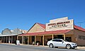 Shop
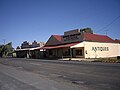
Shop Church Building
 Hotel
Hotel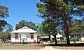 Public School
 Ovals
Ovals Uniting Church


Notes and references
Wikimedia Commons has media related to Matong.
- Australian Bureau of Statistics (27 June 2017). "Matong (State Suburb)". 2016 Census QuickStats. Retrieved 18 February 2019.
| Preceding station | Former Services | Following station | ||
|---|---|---|---|---|
| Grong Grong towards Hay |
Hay Line | Ganmain towards Junee | ||
Текст в блоке "Читать" взят с сайта "Википедия" и доступен по лицензии Creative Commons Attribution-ShareAlike; в отдельных случаях могут действовать дополнительные условия.
Другой контент может иметь иную лицензию. Перед использованием материалов сайта WikiSort.org внимательно изучите правила лицензирования конкретных элементов наполнения сайта.
Другой контент может иметь иную лицензию. Перед использованием материалов сайта WikiSort.org внимательно изучите правила лицензирования конкретных элементов наполнения сайта.
2019-2026
WikiSort.org - проект по пересортировке и дополнению контента Википедии
WikiSort.org - проект по пересортировке и дополнению контента Википедии