world.wikisort.org - Armenia
Gegharkunik (Armenian: Գեղարքունիք, Armenian pronunciation: [ɡɛʁɑɾkʰuˈnikʰ] (![]() listen)) is a province (marz) of Armenia. Its capital and largest city is Gavar.
listen)) is a province (marz) of Armenia. Its capital and largest city is Gavar.
Gegharkunik
Գեղարքունիք | |
|---|---|
Province | |
 Coat of arms | |
 Location of Gegharkunik within Armenia | |
| Coordinates: 40°25′N 45°12′E | |
| Country | Armenia |
| Capital and largest city | Gavar |
| Government | |
| • Governor | Karen Sargsyan[1] |
| Area | |
| • Total | 5,349 km2 (2,065 sq mi) |
| • Rank | 1st |
| Population (2011[2]) | |
| • Total | 235,075 |
| • Estimate (1 January 2019) | 228,300[3] |
| • Rank | 7th |
| • Density | 44/km2 (110/sq mi) |
| Time zone | AMT (UTC+04) |
| Postal code | 1201–1626 |
| ISO 3166 code | AM.GR |
| FIPS 10-4 | AM04 |
| HDI (2017) | 0.724[4] high · 9th |
| Website | Official website |
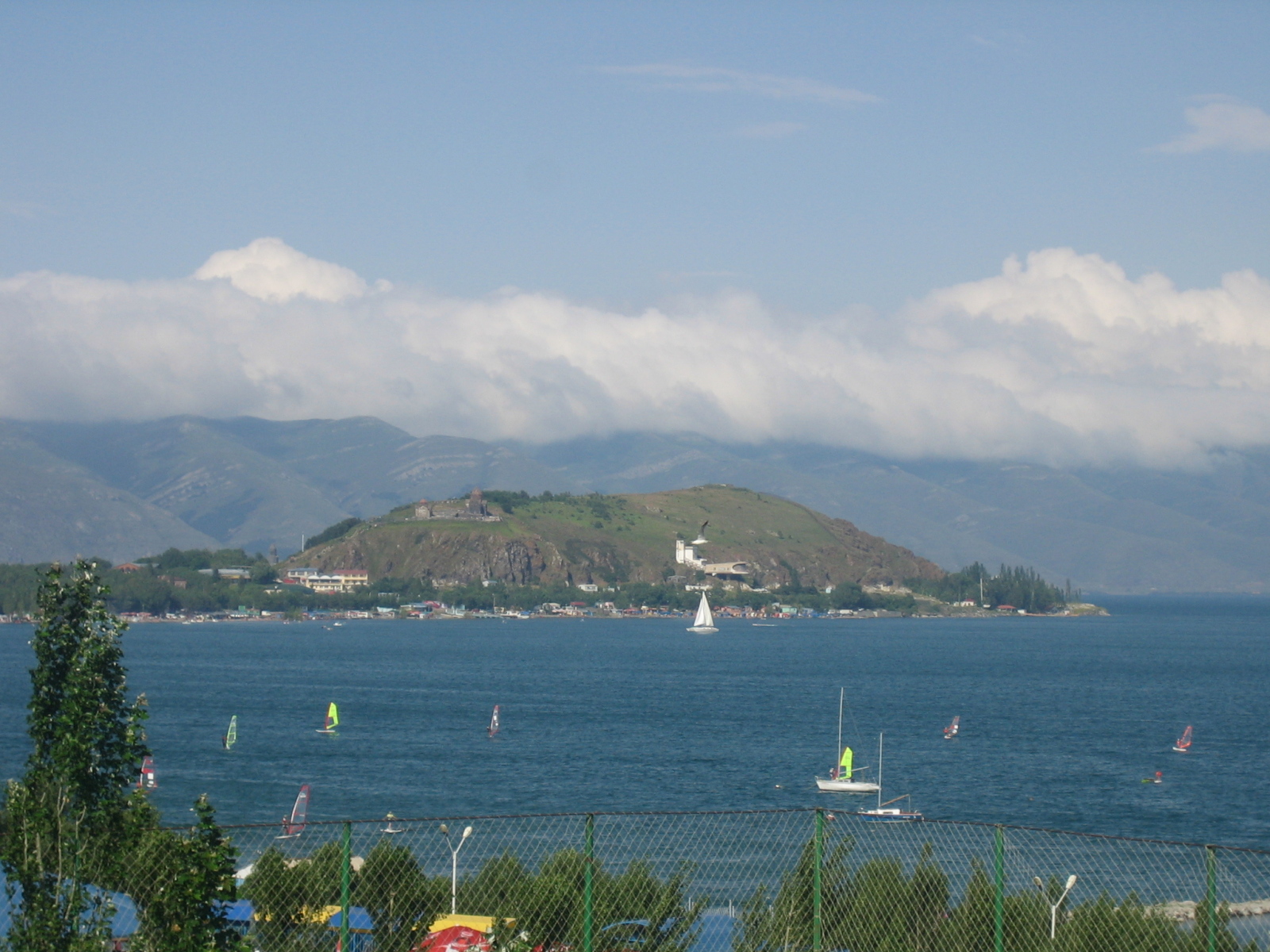
Gegharkunik Province is located at the eastern part of Armenia, bordering Azerbaijan. It includes the exclave of Artsvashen, which has been under Azerbaijani occupation since the First Nagorno-Karabakh War. With an area of 5,348 km2 (2,065 sq mi), Gegharkunik is the largest province in Armenia. However, approximately 24% or 1,278 km2 (493 sq mi) of its territory is covered by Lake Sevan, the largest lake in the South Caucasus and a major tourist attraction of the region.
The Yerevan-Sevan-Dilijan republican highway runs through the province.
Etymology and symbols

| Part of a series on |
| Armenia Հայաստան |
|---|
  |
| Culture |
|
| History |
| Demographics |
| Administrative divisions |
|
The early Armenian history Movses Khorenatsi connected the name of Gegharkunik with Gegham, a 5th-generation descendant of the legendary patriarch and founder of the Armenian nation Hayk.[5] Gegham was the father of Sisak (founder of the Siunia dynasty) and Harma (grandfather of Ara the Beautiful). The Gegham Mountains and the Lake of Gegham (currently known as Lake Sevan) were also named after Gegham.
The region of Gegharkunik has been connected to Uelikuni/Uelikuhi, attested in Urartian sources as one of the local "kingdoms" conquered by Urartu in the eighth century BCE.[6] The word "Uel" is believed to be an early (proto-Armenian) version of "Gegh" (proto-Indo European u corresponds with g in Armenian, l corresponds with the Armenian gh).[6]
Armenian gull is the symbol of the province. It is depicted on the Gegharkunik coat of arms adopted on 4 May 2011, flying over the Lake Sevan and its peninsula, surrounded by the mountains of Sevan. The wheat ears on both sides of the coat of arms represent the agricultural characteristic of the province, while the opened book at the bottom represents the intellectual and cultural heritage of the region.[7]
Geography

Gegharkunik Province occupies the east of the central part of modern-day Armenia. With an area of 5,349 km2 (18% of total area of Armenia), it is ranked first among the provinces of Armenia in terms of the total area.
Gegharkunik Province is situated at the east of modern-day Armenia, surrounding the Lake Sevan. Within Armenia, it borders Tavush Province to the north, Kotayk and Ararat provinces to the west and Vayots Dzor Province to the south. The Dashkasan, Gadabay and Kalbajar districts of Azerbaijan form the eastern border of the province. From 1993 to 2020, the province shared a border with the unrecognized Republic of Artsakh, when the Kalbajar District of Azerbaijan was administered as the Shahumyan Province of Artsakh. The Armenian exclave of Artsvashen in Gegharkunik Province is currently occupied and controlled by Azerbaijan.

Gegharkunik has a mountainous landscape. Its territory is dominated by the Gegham Mountains in the west, the Vardenis Mountains in the south, the Sevan Mountains in the east, the Miapor Mountains in the northeast and the Kenats Mountains in the north of the province. The height of the mountains ranges between 2500 and 3500 meters. Gegharkunik is separated from Vayots Dzor by the 82 kilometer-long Vardenis Mountains, where the highest point is Mount Vardenis at 3,522 meters. The highest point of the province is Mount Azhdahak of the Gegham Mountains with a height of 3597 meters in the western part of the range.

Lake Sevan occupies the central part of the province, lying at a height of 1900 meters above sea level and covering an area of 1260 km2 (around 23.5% of the area of Gegharkunik).[8] The lake is the largest body of fresh water in Armenia and the entire South Caucasus. With a volume of around 32.92 billion m³ of water, Sevan is of a major environmental importance for the entire region. Getik, Gavaraget and Masrik are the main rivers of the province.
The climate of Gegharkunik is cold and snowy in winter, while the summer is characterized with warm and humid climate. The annual precipitation level ranges between 500 and 600 mm at below 2000 meters, while it may reach up to 1000 mm in the mountainous areas.[9]
History
This section needs additional citations for verification. (February 2018) |
Historically, the current territory of the province mainly occupies the Gegharkunik and Sotk cantons of the Syunik province of Ancient Armenia, along with parts of Mazaz and Varazhnunik cantons of Ayrarat province.
From 1930 until 1995, modern-day Gegharkunik was divided into 5 raions within the Armenian SSR: Sevan raion, Kamo raion, Krasnoselsk raion, Martuni raion and Vardenis raion. With the territorial administration reform of 1995, the 5 raions were merged to form the Gegharkunik Province.
After the 2020 Nagorno-Karabakh war, the length of the province's border with Azerbaijan increased. Starting on 12 May 2021, Azerbaijani troops advanced into Gegharkunik province and established positions near the villages of Kut and Verin Shorzha, precipitating a border crisis between Armenia and Azerbaijan.[10][11] On 25 May 2021, an Armenian soldier was killed by Azerbaijani fire in Gegharkunik, and two days later on 27 May, six Armenian soldiers were captured by Azerbaijani forces in Gegharkunik while carrying out engineering work near the border with Azerbaijan.[11]
Demographics
Population
According to the 1989 Soviet census, the Gegharkunik Province (then part of the Vardenis, Kamo, Krasnoselsk, Martuni, and Sevan districts in 1930–1995)[12] had a population of 230,548. 58,185 or 25.24% of which was urban, distributed into the cities of Kamo (31,234) and Sevan (26,951), and 172,363 or 74.76% were rural, distributed into the districts of Vardenis (31,282), Kamo (30,555), Krasnoselsk (16,428), Martuni (75,866), and Sevan (18,232).[13]
According to the 2011 official census, Gegharkunik has a population of 235,075 (119,180 men and 115,895 women), forming around 7.8% of the entire population of Armenia. The urban population is 71,423 (30.4%) and the rural is 163,652 (69.6%). The province has 5 urban and 87 rural communities. The largest urban community is the provincial centre of Gavar, with a population of 20,765. The other urban centres of are Sevan, Martuni, Vardenis and Chambarak.
With a population of 9,880, the village of Vardenik is the largest rural municipality of Gegharkunik. Vardenik is also the largest rural community in Armenia.
Ethnic groups and religion

Gegharkunik Province is almost entirely populated by ethnic Armenians who belong to the Armenian Apostolic Church. The regulating body of the church is the Diocese of Gegharkunik, headed by Bishop Markos Hovhannisyan. The Holy Mother of God Cathedral in Gavar is the seat of the diocese.
In 1992, the Artsvashen exclave was occupied by Azerbaijan and resettled by Azerbaijanis.
The villages of Chkalovka (formerly Aleksandrovka) and Semyonovka were founded by Russian Molokans during the 1st half of the 19th century. Currently, very few Molokans still reside in the two villages.
The regions of Vardenis and Chambarak used to have a significant Azerbaijani minority. However, after the break-out of the First Nagorno-Karabakh War in 1988, the Azerbaijanis were expelled and replaced by Armenian refugees who were displaced from several regions of Azerbaijan.
Administrative divisions
Gegharkunik Province is currently divided into 57 municipal communities (hamaynkner).[14][15][16]
- A cross denotes a town (urban settlement), otherwise, the settlements are villages (rural settlements).
| Community | Area (km2) | Population (2017 est.) |
Centre | Settlements |
|---|---|---|---|---|
| Chambarak Community | Chambarak |
Antaramej, Artsvashen, Aygut, Barepat, Dprabak, Dzoravank, Getik, Kalavan, Martuni, Ttujur, Vahan | ||
| Gavar Community | 16 | 19,500 | Gavar |
|
| Martuni Community | 10 | 12,200 | Martuni |
|
| Sevan Community | Sevan |
Gagarin | ||
| Vardenis Community | Vardenis |
Ayrk, Azat, Geghamabak, Jaghatsadzor, Kut, Nerkin Shorzha, Norabak, Shatjrek, Shatvan Verin Shorzha |
Rural communities and included settlements:
- Akhpradzor
- Akunk
- Artsvanist
- Astghadzor
- Berdkunk
- Chkalovka
- Ddmashen
- Dzoragyugh
- Gandzak
- Geghakar
- Geghamasar Municipality, centre: Sotk
- Geghamavan
- Gegharkunik
- Geghhovit
- Hayravank
- Karchaghbyur
- Karmirgyugh
- Khachaghbyur
- Lanjaghbyur
- Lchap
- Lchashen
- Lchavan
- Lichk
- Lusakunk
- Madina
- Makenis
- Mets Masrik
- Nerkin Getashen
- Norakert
- Norashen
- Noratus
- Sarukhan
- Semyonovka
- Shoghakat
- Torfavan
- Tsaghkashen
- Tsaghkunk
- Tsakkar
- Tsovagyugh
- Tsovasar
- Tsovazard
- Tsovak
- Tsovinar
- Vaghashen
- Vanevan
- Vardadzor
- Vardenik
- Varser
- Verin Getashen
- Yeranos
- Zolakar
- Zovaber
In recent years, many rural settlements in Gegharkunik have been abandoned, such as the villages of Chapkut, Chichakli, Karakoyun, Karmirkharab, Kizilkharaba, Nshkhark and Zariver.
Culture
There are cultural palaces and many public libraries in the urban settlements of the province. A geological museum operates in Sevan on the basis of the Sevan Botanical Garden. Gavar is home to a history museum as well as drama theatre.
The cuisine of Gavar is closely related with the oriental cuisine elements, characterized with various spices, vegetables, fish, and fruits combination. One of the famous sweets of the town is the Kyavar baklava which is a many-layered pastry with tissue-thin sheets of phyllo dough, filled with nuts and sugar and finished with a dousing of hot honey.
The summer presidential residence of Armenia is located at the Sevan Peninsula.
Fortresses and archaeological sites

- Mount Azhdahak Petroglyphs: A great number of prehistoric petroglyphs have been found in the surroundings of Mount Azhdahak. Most images depict men in scenes of hunting and fighting, as well as astronomical bodies and phenomena: the Sun, the Moon, constellations, the stellar sky, lightning, and many others.
- Lchashen Cyclopean Fortress: the site is home to an ancient settlement, a burial place and a cyclopean fortress dating back to the 4th millennium-7th century BC.
- Sevsar Ancient Astronomical Observatory: at the western slopes of Mount Sevsar, dating back to the 3rd-1st millennia BC. Recent studies suggest the birthplace of the naming of the constellations and the creation of the zodiac is in the Armenian plateau.
- Berdkunk Fortress of the 1st millennium BC
- Teyseba archaeological site of the Urartian period, 8th century BC
- Odzaberd fortress, 8th century BC
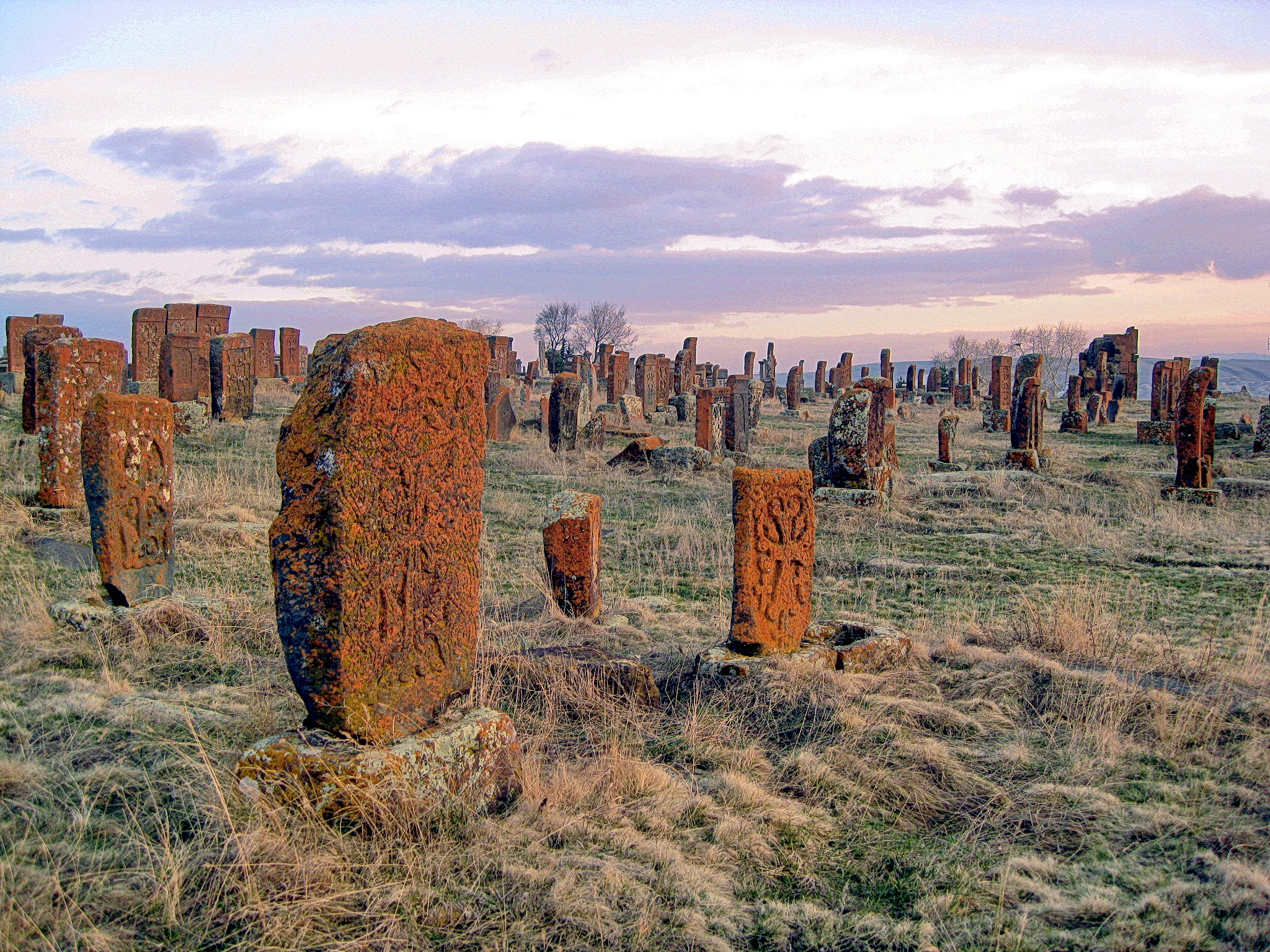
- Noratus cemetery of the 10th century
Churches and monasteries

- Shoghagavank Monastery of the 5th century
- Saint Thaddeus Church of Ddmashen, 7th century
- Hatsarat Monastery of the 7th century
- Sevanavank monastic complex of the 9th century
- Hayravank Monastery of the 9th century
- Makenyats Vank monastic complex of the 9th century
- Kotavank monastery of the Holy Mother of God, 9th century
- Surp Hovhannes Church of Tsaghkashen, 9th century
- Shoghagavank monastic complex of the 9th century
- Vanevan Monastery, opened in 903
Media
Gegharkunik has four regional TV stations:
- Zangak TV, based in Martuni, operating since 1996
- Kyavar TV, based in Gavar, operating since 1997
- Sevan TV (STV 1), based in Sevan, operating since 1999
- Geghama TV, based in Sevan, operating since 2010
Transportation

The province is connected with other parts of Armenia through the M-4, M-10 and M-14 Motorways. The M-11 Motorway that passes through Martuni and Vardenis connects the province with the town of Karvachar of the Nagorno-Karabakh Republic. The Vardenis-Martakert highway, the second highway connecting Armenia with Nagorno-Karabakh, was opened in September 2017.[17] Part of the highway came under the control of Azerbaijan as a result of the 2020 Nagorno-Karabakh war and currently cannot be used by Armenians.[18]
Sevan has a train station that connects the town with Yerevan through railway. The provincial centre Gavar has had an airstrip since the Soviet years, located to the north of the town.
Economy
Agriculture

The economy of Gegharkunik Province has a predominantly agricultural orientation, including farming and cattle-breeding. It has a share of 18% in the annual total agricultural product of Armenia. Around 65% (3,487 km2) of the total area of the province are arable lands, out of which 27.3% (951.5 km2) are ploughed.[19] Around 60,000 farms in Gegharkunik are operated by the private sector. The main crops are potato and grains.
Fishing and fish farming is also dominant in the province. Recently, beekeeping has significantly developed.
Industry
Generally, Gegharkunik has a poor industrial index with a small number of operating firms. Currently, the province has a contribution of only 2% in the annual total industrial product of Armenia.
- The Sotk gold mine near Vardenis has one of the largest gold deposits in Armenia. It is owned and operated by the "GeoProMining Gold" company. After the 2020 Nagorno-Karabakh war, half of the mine came under the control of Azerbaijan.[20] The town of Vardenis is home to the "Samelon Vardenis Sea-Buckthorn Processing Plant" for alcoholic beverages and soft drinks, founded in 2000. It is also home to the "Gnel Khachatryan" plant for dairy products, as well as many small furniture manufacturing plants.
- The town of Sevan is home to the beer manufacturers "Lihnitis Sevan Brewery" founded in 2007, with a variety of lager beer under the brand "Kellers". It is also home to the Sevan bread and bakery factory operating since 1947, as well as the Sevan Sugar Plant founded in 2003. The "Yerknain Manana" confectionery plant and the "Tuff-Granite" mining plant are also based in Sevan.
- Gavar is home to the "Gavar Furniture Factory" since 1948, the "Sevan Mineral Water Plant" founded in 1953 (reopened in 2015), the "Aquatic LLC" for processed crayfish founded in 2002, the "Kirakosyan" furniture factory founded in 2006, the "Shushan Production Cooperative" for soft drinks, "Artsrun and Sons" for dairy products in Martuni village, and the "Atast Food" in Verin Getashen.
- Chambarak is home to the Chambarak Cheese Factory as well as the "La-Mar Stone Mining" plant. Martuni is home to the "Arev-1" bread factory (since 1995), and the "Golden Lens" coffee processing plant (since 1998).
- The village of Karmirgyugh is home to the "Yengoyan" carpet factory founded in 1958 (privatized in 1996). The "Arax-2 Production Cooperative" for dairy products is operating in the village of Akunk since 1996. The "Tarzu-Levon" factory for soft drinks is operating in Dzovazard village since 1999. The "AMA Compressor LLC" for industrial equipment is operating in the village of Gagarin since 2003. The "Sahakyan LLC" smart systems manufacturers are operating in Ddmashen village since 2012.
Tourism


Tourism services in Gegharkunik are seasonal. The towns of Sevan, Chambarak and Martuni along with their surrounding beaches are a major summer destination for locals and foreigners with many hotels and resorts. The cultural heritage and the natural monuments of the region attract the tourists too.
During the last decade, many new hotels and spa resorts were opened along the coast of Lake Sevan, including the Harsnaqar Hotel and Water Park, the Best Western Bohemian Resort Sevan, the Akhtamar Sevan Hotel, the Tufenkian Avan Marag Hotel of Tsapatagh, the Blue Sevan Rest-house near Tsovagyugh, the Maria Resort Sevan and the Lavanda City cottages.
In February 2011, the Sevan ropeway was opened at the north of the town, in the area known as "mashtotsner", on the way to Tsovagyugh village. It has a length of 1,130 meters.[21]
Many forests of the province are listed among the protected areas of Armenia, including the Sevan National Park, the Getik Sanctuary, and the Juniper Woodlands Sanctuary of the mountains of Sevan. The Sevan Botanical Garden is also a major destination for the lovers of ecotourism.
Education

As of 2016, Gegharkunik Province has 126 public schools.[22]
Two major educational institutions currently operating in Gegharkunik are:
- The Gavar State University was opened in 1993 after the independence of Armenia. With its five faculties the university is a major educational centre for the entire province of Gegharkunik. It provides degrees in Philology, Natural Sciences, Humanities, Economics and Education. Now more than 2,400 students are attending the university.
- The Vaskenian Theological Academy on the Sevan peninsula is a leading institution of theological studies, Armenian literature, history, art, liturgy and traditions of the Armenian Church.
Sport
During the brief summer of the region, Sevan and the nearby beaches tun into a popular beach resort. Many professionals and amateurs visit the region to practice their favourite types of sports including beach soccer, beach volleyball and windsurfing.
The defunct football teams of FC Akhtamar Sevan and Lernagorts Vardenis FC represented the province at the domestic competitions during the 1990s. Alashkert FC represented town of Martuni between 1990 and 2000 before being relocated to Yerevan.
There are football stadiums with small seating capacities in Sevan, Martuni, Vardenis and the village of Lchashen.
People
Natives of the province include:
- Ivan Gevorkian (1907–1989), Soviet-Armenian surgeon and scientist
- Frunze Dovlatyan (1927–1997), film director, actor and screenwriter.
- Hranush Hakobyan (1954–), politician and former minister of diaspora.
- Arsen Grigoryan (1982–), Armenian singer and actor.
See also
References
- LLC, Helix Consulting. "Karen Sargsyan appointed Gegharkunik governor". www.panorama.am.
- Gegharkunik population, 2011 census
- "Statistical Committee of the Republic of Armenia". armstat.am.
- "Sub-national HDI - Area Database - Global Data Lab". hdi.globaldatalab.org. Retrieved 13 September 2018.
- Hakobyan, Tadevos Kh.; Melik-Bakhshyan, Stepan T.; Barseghyan, Hovhannes Kh. (1986). Հայաստանի և հարակից շրջանների տեղանունների բառարան [Dictionary of toponymy of Armenia and adjacent territories] (in Armenian). Vol. 1. Yerevan: Yerevan State University Publishing House. p. 827.
- Petrosyan, Armen (2016). "Indo-European *wel- in Armenian mythology. Journal of Indo-European studies, 2016, 1-2, pp. 129-146". The Journal of Indo-European Studies. 44: 129–146 – via Academia.edu.
- "Մրցույթ' Գեղարքունիքի մարզի հուշամեդալի եւ զինանշանի էսքիզի ստեղծման համար". armenpress.am.
- "agro.am". gegharkunik.agro.am.
- "Սևանա լիճ | Սևանա Լիճ". sevanlake.am.
- "Azerbaijanis cross Armenia's state border near Kut village as well". news.am. 14 May 2021. Retrieved 14 May 2021.
- Arakelian, Leeza (27 May 2021). "Azeri forces capture six Armenian soldiers in Gegharkunik". The Armenian Weekly. Retrieved 5 June 2021.
{{cite web}}: CS1 maint: url-status (link) - "Legislation: National Assemly of RA". www.parliament.am. Retrieved 11 February 2022.
- "Демоскоп Weekly - Приложение. Справочник статистических показателей". www.demoscope.ru. Retrieved 10 February 2022.
- "RA Gegharkunik Marz" (PDF). Marzes of the Republic of Armenia in Figures, 2002–2006. National Statistical Service of the Republic of Armenia. 2007.
- "Գեղարքունիքի մարզպետարան". gegharkunik.mtad.am.
- "Հայաստանի 328 համայնքների միավորմամբ կձևավորվի 34 համայնք. ԱԺ-ն քննարկում է ծրագիրը | Լրագիր".
- "Բացվել է Վարդենիս-Մարտակերտ ճանապարհը" [The Vardenis-Martakert road has opened]. Hetq.am (in Armenian). 1 September 2017. Retrieved 5 June 2021.
{{cite web}}: CS1 maint: url-status (link) - Badalyan, Susan (25 January 2021). "Վարդենիս - Քարվաճառ ավտոճանապարհը կարող է դառնալ բանակցությունների թեմա" [The Vardenis-Karvachar highway may become the subject of negotiations]. Azatutyun (in Armenian). Retrieved 5 June 2021.
{{cite web}}: CS1 maint: url-status (link) - "Armstat, Gegharkunik Province" (PDF).
- Ghukasyan, Seda (26 November 2020). "Half of Sotk Gold Mine Now in Azerbaijan, Says Armenian Military Official". Hetq.am. Retrieved 5 June 2021.
{{cite web}}: CS1 maint: url-status (link) - "Փետրվարի 15-ին Սևանա լճի մոտ նոր ճոպանուղի կբացվի". PanARMENIAN.Net.
- "Gegharkunik Province schools" (PDF). Archived from the original (PDF) on 24 September 2011.
External links
Capital: Gavar | ||
| Urban communities |  | |
| Rural communities |
| |
| Non-community settlements | ||
| Abandoned settlements | ||
Provinces of Armenia | ||
|---|---|---|
| Provinces (մարզեր) | ||
| City with special status |
| |
На других языках
[de] Gegharkunik
Gegharkunik (.mw-parser-output .IPA a{text-decoration:none}[ɡɛʁɑɾkʰuˈnikʰ] , armenisch Գեղարքունիք, in wissenschaftlicher Transliteration Gełark‘yownik‘) ist eine der Provinzen Armeniens.- [en] Gegharkunik Province
Другой контент может иметь иную лицензию. Перед использованием материалов сайта WikiSort.org внимательно изучите правила лицензирования конкретных элементов наполнения сайта.
WikiSort.org - проект по пересортировке и дополнению контента Википедии