world.wikisort.org - Armenia
Karmirgyugh (Armenian: Կարմիրգյուղ; lit. 'Red Village') is a village in the Gegharkunik Province of Armenia.
Karmirgyugh
Կարմիրգյուղ | |
|---|---|
 A view of Karmirgyugh | |
 Karmirgyugh  Karmirgyugh | |
| Coordinates: 40°19′50″N 45°11′02″E | |
| Country | |
| Province | Gegharkunik |
| Founded | 1831 |
| Population (2011)[1] | |
| • Total | 4,964 |
| Time zone | UTC+4 (AMT) |
| Karmirgyugh at GEOnet Names Server | |
Toponymy
The village is also known as Gyukh, and was known as Kulali and Ghulali until 1940.
History
The village was founded in 1831 by emigrants from Gavar. It contains two churches with khachkars, St. Astvatsatsin and St. Grigor, and was the discovery site of a boundary stone of King Artashes, inscribed in Aramaic. There are also Urartian ruins nearby.[2]
Gallery
 St. Astvatsatsin Church
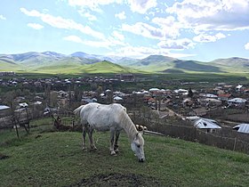 Scenery around Karmirgyugh
 St. Grigor Church
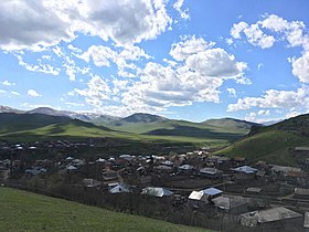 A view of Karmirgyugh and surrounding mountains
 St. Grigor Church and khachkars
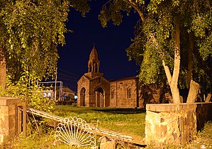 St. Astvatsatsin Church


References
- Statistical Committee of Armenia. "The results of the 2011 Population Census of Armenia" (PDF).
- Kiesling, Brady; Kojian, Raffi (2005). Rediscovering Armenia: Guide (2nd ed.). Yerevan: Matit Graphic Design Studio. p. 78. ISBN 99941-0-121-8.
External links
Wikimedia Commons has media related to Karmirgyugh.
- Report of the results of the 2001 Armenian Census, Statistical Committee of Armenia
- Brady Kiesling, Rediscovering Armenia, p. 44; original archived at Archive.org, and current version online on Armeniapedia.org.
Capital: Gavar | ||
| Urban communities |  | |
| Rural communities |
| |
| Non-community settlements |
| |
| Abandoned settlements | ||
This article about a location in Gegharkunik Province, Armenia is a stub. You can help Wikipedia by expanding it. |
Текст в блоке "Читать" взят с сайта "Википедия" и доступен по лицензии Creative Commons Attribution-ShareAlike; в отдельных случаях могут действовать дополнительные условия.
Другой контент может иметь иную лицензию. Перед использованием материалов сайта WikiSort.org внимательно изучите правила лицензирования конкретных элементов наполнения сайта.
Другой контент может иметь иную лицензию. Перед использованием материалов сайта WikiSort.org внимательно изучите правила лицензирования конкретных элементов наполнения сайта.
2019-2026
WikiSort.org - проект по пересортировке и дополнению контента Википедии
WikiSort.org - проект по пересортировке и дополнению контента Википедии