world.wikisort.org - Armenia
Tsovak (Armenian: Ծովակ) is a village in the Gegharkunik Province of Armenia.
Tsovak
Ծովակ | |
|---|---|
 A view of Tsovak | |
 Tsovak  Tsovak | |
| Coordinates: 40°10′58″N 45°38′02″E | |
| Country | |
| Province | Gegharkunik |
| Elevation | 1,920 m (6,300 ft) |
| Population (2011)[1] | |
| • Total | 2,319 |
| Time zone | UTC+4 (AMT) |
| Postal code | 1612 |
| Tsovak at GEOnet Names Server | |
Toponymy
The village was previously known as Nerkin Zagalu and Nizhniy Zagalu.
History
The village is the site of a large Iron Age fort atop the hill to the south and west, with an 8th-century BCE cuneiform inscription of Sarduri II cut into the stone at the north edge of the fortification.[2]
Gallery
 Khachkars in Tsovak
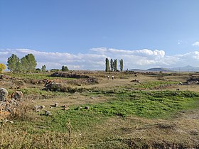 Tsovak castle
 Yot Axper chapel
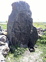 Khachkar in Yot Axper chapel
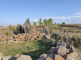 Yot Axper chapel


References
- Statistical Committee of Armenia. "The results of the 2011 Population Census of Armenia" (PDF).
- Kiesling, Brady; Kojian, Raffi (2005). Rediscovering Armenia: Guide (2nd ed.). Yerevan: Matit Graphic Design Studio. p. 81. ISBN 99941-0-121-8.
External links
Wikimedia Commons has media related to Tsovak.
- World Gazeteer: Armenia[dead link] – World-Gazetteer.com
- Report of the results of the 2001 Armenian Census, Statistical Committee of Armenia
- Brady Kiesling, Rediscovering Armenia, p. 47; original archived at Archive.org, and current version online on Armeniapedia.org.
Capital: Gavar | ||
| Urban communities |  | |
| Rural communities |
| |
| Non-community settlements |
| |
| Abandoned settlements | ||
This article about a location in Gegharkunik Province, Armenia is a stub. You can help Wikipedia by expanding it. |
На других языках
- [en] Tsovak
[ru] Цовак
Цова́к (арм. Ծովակ, ранее Загалу, Нижний Загалу) — село в Армении, в Гехаркуникской области.Текст в блоке "Читать" взят с сайта "Википедия" и доступен по лицензии Creative Commons Attribution-ShareAlike; в отдельных случаях могут действовать дополнительные условия.
Другой контент может иметь иную лицензию. Перед использованием материалов сайта WikiSort.org внимательно изучите правила лицензирования конкретных элементов наполнения сайта.
Другой контент может иметь иную лицензию. Перед использованием материалов сайта WikiSort.org внимательно изучите правила лицензирования конкретных элементов наполнения сайта.
2019-2026
WikiSort.org - проект по пересортировке и дополнению контента Википедии
WikiSort.org - проект по пересортировке и дополнению контента Википедии