world.wikisort.org - USA
Vermilion County is a county in the eastern part of the U.S. state of Illinois, between the Indiana border and Champaign County. It was established in 1826 and was the 45th of Illinois' 102 counties. According to the 2010 United States Census, it had a population of 81,625, a decrease of 2.7% in 2000.[1] It contains 21 incorporated settlements; the county seat and largest city is Danville.[2]
Vermilion County, Illinois | |
|---|---|
County | |
 Vermilion County Courthouse | |
 Seal | |
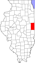 Location within Illinois | |
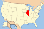 Illinois' location within the United States | |
| Coordinates: 40°07′28.13″N 87°37′48.07″W | |
| Country | United States |
| State | Illinois |
| Region | Central Illinois |
| Metro area | Danville Metropolitan |
| Incorporated | Jan 18, 1826 |
| Named for | Vermilion river |
| County seat and largest city | Danville |
| Area | |
| • Total | 901.28 sq mi (2,334.3 km2) |
| • Land | 898.37 sq mi (2,326.8 km2) |
| • Water | 2.91 sq mi (7.5 km2) |
| • Rank | 7th largest county in Illinois |
| Population (2020) | |
| • Total | 74,188 |
| • Density | 82/sq mi (32/km2) |
| Time zone | UTC−6 (Central) |
| • Summer (DST) | UTC−5 (Central) |
| ZIP Code prefixes | 60932, 60942, 60960, 60963, 61810, 61811, 61812, 61814, 61817, 61831, 61832, 61833, 61834, 61841, 61844, 61846, 61848, 61849, 61850, 61857, 61858, 61859, 61862, 61865, 61870, 61876, 61883 |
| Area codes | 217/447 |
| Website | www.vercounty.org |
Vermilion County is part of the Danville, Illinois, Metropolitan Statistical Area.
History
Vermilion County is named after the Vermilion River, which passes through the county and empties into the Wabash River in Indiana near Cayuga; the river was so named because of the color of the earth along its route.[3][4]
The area which became Vermilion County was under the flag of France from 1682 to 1763, as part of New France.
It was taken over by Great Britain for fifteen years after the French and Indian War; it then became part of the colonies after the Revolutionary War when the area was ceded to Virginia, titled "the Illinois County of Virginia". Later it was part of the Indiana Territory, then the Illinois Territory, and finally the state of Illinois.[5] The county was created on 18 January 1826, from a portion of Edgar County. There was an unorganized territory to the north and west which was attached to the county; Champaign and Iroquois counties were formed from part of this territory in 1833. The remainder was used to create Ford County in 1859, the last Illinois county to be formed.
The county's saline springs were a strong attraction to early explorers; they were mentioned as early as 1801. Joseph Barron, an interpreter fluent in several Native American languages, stated in an affidavit that he was present at the "Vermilion Salines" that year. The production required 100 gallons of water for one bushel of salt and proved to be profitable from the first run (1822–1829), when salt became less expensive and the venture was no longer economical.[6]
The area's first settlement was made in 1819 near these saline springs, by the Treat, Beckwith, and Whitcomb. James Butler, from Ohio, followed in 1820 and settled in the Catlin area; within a few years, the settlement grew to encompass several families and became known as "Butler's Point". In the southern part of the county, Henry Johnson built a cabin west of present-day Georgetown; this area was known as "Johnson's Point". The southern portion of the county was soon filled with small settlements. Most settlers in Vermilion County came from the American South, who had left because of their opposition to slavery.[7]
Some of the early settlers were of the Religious Society of Friends, or Quakers. They founded the settlement of Vermilion Grove in the south part of the county, one of the county's first settlements and the site of the county's second public school.
The county has strong ties to Abraham Lincoln, who practiced law in Danville from 1841 to 1859 with Ward Hill Lamon; Lamon later served as Lincoln's bodyguard. Lincoln spoke in Danville during his 1858 campaign for a seat in the US Senate. Lincoln gave the speech in his stocking feet from the balcony of Dr. William Fithian, a prominent local physician. The Fithian home is now listed on the National Register of Historic Places and serves as the Vermilion County Museum;[8] visitors can see Lincoln memorabilia including a bed in which Lincoln slept.[9]
The various stages in the evolution of Vermilion County are shown below.[10]
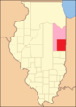 Vermilion County from the time of its creation to 1831, including a large tract of unorganized territory temporarily attached to it.
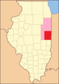 Vermilion between 1831 and 1833
 The county between 1833 and 1836, after creation of Champaign and Iroquois Counties
 Vermilion County between 1836 and 1837
 Vermilion County between 1837 and 1853
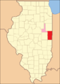 Vermilion County after 1853, when the unorganized territory was reduced to its current size.
 In 1859, the additional territory was split off as Ford County, reducing Vermilion to its current borders.


Geography

Vermilion County is located along the eastern border of Illinois; its northern border is about 95 miles (153 km) south of Chicago.
Vermilion County in Illinois and Vermillion County in Indiana are two of twenty-two counties or parishes in the United States with the same name to border each other across state lines.[11] According to the 2010 census, the county has a total area of 901.28 square miles (2,334.3 km2), of which 898.37 square miles (2,326.8 km2) (or 99.68%) is land and 2.91 square miles (7.5 km2) (or 0.32%) is water.[12] The land in Vermilion County consists mostly of various forms of silt loam.[13] Lake Vermilion, a man-made 1,000-acre (400 ha) reservoir, is the county's largest body of water, located northwest of Danville. It provides the city's culinary water, and also provides recreation opportunities.
Adjacent counties
- Iroquois County – north
- Benton County, Indiana – northeast
- Warren County, Indiana – east
- Vermillion County, Indiana – southeast
- Edgar County – south
- Douglas County - southwest
- Champaign County – west
- Ford County – northwest
Cities
- Danville (county seat)
- Hoopeston
- Georgetown[14]
Villages
- Allerton – at SW corner of county; extends into Champaign County
- Alvin – north of Danville
- Belgium – on Route 1
- Bismarck – north of Danville
- Catlin – southwest of Danville
- Fairmount – southwest of Danville
- Fithian – west of Danville on US 150
- Henning – north of Danville on US 136
- Indianola – southwest of Danville
- Muncie – west of Danville on US 150
- Oakwood – west of Danville on US 150
- Potomac – on US 136 north of Danville
- Rankin – at NW corner of county
- Ridge Farm
- Rossville – on Route 1, south of Hoopeston
- Sidell – east of Allerton
- Tilton
- Westville
Unincorporated communities
Previous settlements
Several towns were established in the county which no longer survive. In some cases, the coming of the railroads helped to define the best locations for settlements, and as a result some existing towns were abandoned. When Lake Vermilion was created, the town of Denmark was flooded and now lies at the bottom of the reservoir.
- Archie (south of Sidell)[15]
- Blue Grass City[15]
- Butler's Point (see Catlin)
- Conkeytown
- Denmark
- Ellis[15] (Middlefork Township)
- Franklin (see Bismarck)
- Geneva
- Gilbert (see Alvin)
- Humrick
- Johnsonville (Blount Township)
- Munroe
- Myersville (see Bismarck)
- Pellsville (see Rankin)
- Prospect City[15]
- Reilly (Butler Township)
- Shepherd's Town
- Watkins Grove (or Watkins Glen)
- Weaver City (see Ambia, Indiana)
Townships
Township government was adopted in Vermilion County in 1851, and eight townships were created:
- Carroll
- Danville
- Elwood
- Georgetown
- Middlefork
- Newell (first called Richland)
- Pilot
- Ross
Eleven additional townships were created in the following decades:
Parks
The Vermilion County Conservation District operates four parks:
- Forest Glen Preserve
- Heron County Park
- Kennekuk Cove County Park
- Lake Vermilion County Park[17]
The Illinois Department of Natural Resources manages three areas in the county:
- Kickapoo State Recreation Area
- Harry "Babe" Woodyard State Natural Area
- Middle Fork State Fish and Wildlife Area[18]
Demographics
| Historical population | |||
|---|---|---|---|
| Census | Pop. | %± | |
| 1830 | 5,836 | — | |
| 1840 | 9,303 | 59.4% | |
| 1850 | 11,492 | 23.5% | |
| 1860 | 19,800 | 72.3% | |
| 1870 | 30,388 | 53.5% | |
| 1880 | 41,588 | 36.9% | |
| 1890 | 49,905 | 20.0% | |
| 1900 | 65,635 | 31.5% | |
| 1910 | 77,996 | 18.8% | |
| 1920 | 86,162 | 10.5% | |
| 1930 | 89,339 | 3.7% | |
| 1940 | 86,791 | −2.9% | |
| 1950 | 87,079 | 0.3% | |
| 1960 | 96,176 | 10.4% | |
| 1970 | 97,047 | 0.9% | |
| 1980 | 95,222 | −1.9% | |
| 1990 | 88,257 | −7.3% | |
| 2000 | 83,919 | −4.9% | |
| 2010 | 81,625 | −2.7% | |
| 2020 | 74,188 | −9.1% | |
| US Decennial Census[19] 2012 Estimate[20] | |||
As of the 2010 United States Census, there were 81,625 people, 32,655 households, and 21,392 families residing in the county.[21] The population density was 90.9 inhabitants per square mile (35.1/km2). There were 36,318 housing units at an average density of 40.4 per square mile (15.6/km2).[22] The racial makeup of the county was 82.5% white, 13.0% black or African American, 0.7% Asian, 0.2% American Indian, 1.5% from other races, and 2.2% from two or more races. Those of Hispanic or Latino origin made up 4.2% of the population. In terms of ancestry, 21.2% self-identified as American, 18.9% as German, 10.1% as Irish, and 9.1% as English.[23]
Of the 32,655 households, 31.4% had children under the age of 18 living with them, 45.7% were married couples living together, 14.7% had a female householder with no husband present, 34.5% were non-families, and 29.8% of all households were made up of individuals. The average household size was 2.41 and the average family size was 2.96. The median age was 39.8 years.
The median income for a household in the county was $39,456 and the median income for a family was $49,429. Males had a median income of $40,107 versus $30,104 for females. The per capita income for the county was $20,218. About 14.6% of families and 18.7% of the population were below the poverty line, including 30.0% of those under age 18 and 9.1% of those age 65 or over.[24]
Climate and weather
| Danville, Illinois | ||||||||||||||||||||||||||||||||||||||||||||||||||||||||||||
|---|---|---|---|---|---|---|---|---|---|---|---|---|---|---|---|---|---|---|---|---|---|---|---|---|---|---|---|---|---|---|---|---|---|---|---|---|---|---|---|---|---|---|---|---|---|---|---|---|---|---|---|---|---|---|---|---|---|---|---|---|
| Climate chart (explanation) | ||||||||||||||||||||||||||||||||||||||||||||||||||||||||||||
| ||||||||||||||||||||||||||||||||||||||||||||||||||||||||||||
| ||||||||||||||||||||||||||||||||||||||||||||||||||||||||||||
Vermilion County is in the humid continental climate region of the United States along with most of Illinois. Its Köppen climate classification is Dfa,[26] meaning that it is cold, has no dry season, and has a hot summer.[27] In recent years, average temperatures in Danville have ranged from a low of 17 °F (−8 °C) in January to a high of 86 °F (30 °C) in July, although a record low of −26 °F (−32 °C) was recorded in January 1994 and a record high of 112 °F (44 °C) was recorded in July 1936. Average monthly precipitation ranged from 1.99 inches (51 mm) inches in February to 4.70 inches (119 mm) inches in June.[25]
Transportation
- Interstate 74 enters Vermilion County from the west on its way from Champaign–Urbana, and passes just to the north of the towns of Fithian, Muncie and Oakwood before passing through the south edge of the Kickapoo State Park, the north edge of Tilton and the south edge of Danville. Continuing east, it leaves the county and the state on its way to Indianapolis.[28]
- US Route 136, which runs across five states, passes into Vermilion County from the west on its way from Rantoul. It passes east through the towns of Armstrong, Potomac and Henning; it reaches Illinois Route 1 south of Rossville and then shares that highway's route as it passes south through Danville. At the south edge of Danville it reaches Main Street and resumes its eastward heading, leaving the east edge of Danville and passing out of the county and state on its way to Covington, Indiana.[29]
- US Route 150 enters the county from Champaign–Urbana to the west, running just to the south of Interstate 74 and passing through the towns of Fithian, Muncie and Oakwood. Just west of Danville it crosses to the north side of Interstate 74 as that highway veers to the southeast. In downtown Danville, it meets Illinois Route 1 and U.S. Route 136, and follows Route 1 to the south and continues through the towns of Belgium, Westville, Georgetown and Ridge Farm before entering Edgar County further to the south.[30]
- Illinois Route 1 runs from the north to the south through the county, passing through Hoopeston, Rossville, Danville, Belgium, Westville, Georgetown and Ridge Farm.[31]
- Illinois Route 9 runs from west to east near the north edge of the county and passes through Rankin and Hoopeston; upon reaching the Indiana border
- Indiana State Road 26 continues its route to the east toward Lafayette, Indiana.[32]
- Illinois Route 49 is a north–south highway near the western edge of the county. It passes south through Rankin where it intersects Route 9; further south it passes near Armstrong where U.S. Route 136 briefly shares its route. Crossing Interstate 74, it shares the route of U.S. Route 150, running west for about 2 miles (3.2 km) and leaving the county before continuing south in Champaign County.[33]
- Illinois Route 119 is a short 8-mile (13 km) east–west road that connects the intersection of Illinois Route 1 and U.S. Route 136 with Indiana State Road 28 at the state line.[34]
Four railroad lines pass through or into the county, all intersecting in the Danville area; this results in many different railroad crossings throughout the city:
- Norfolk Southern Railway line – enters the county from Decatur to the southwest and passes through Danville on its way to Lafayette, Indiana to the northeast
- CSX Transportation line - north-south through the county, connecting Chicago and Terre Haute, Indiana via Paris
- Kankakee, Beaverville and Southern Railroad line – north–south line through the county, to the east of the CSX line, a few miles from the state border, beginning in northern Iroquois County and running south through Danville, then veering east.[35]
- Vermilion Valley Railroad line – a 6-mile (9.7 km) line that connects the Flex-N-Gate factory west of Covington, Indiana with CSX in Danville.[36]
The Vermilion Regional Airport is located northeast of Danville.
Economy
For 2014, Vermilion County had a workforce of 35,643 people; 32,584 were employed and 3,059 (8.6%) were unemployed.[37]
Education
There are 12 school districts in the county that provide primary and secondary education.[38] There are two post-secondary educational institutions: Danville Area Community College, a public two-year community college, and Lakeview College of Nursing, a four-year private institution (both located in Danville).
Government
Based on the 2000 census, Vermilion County is part of the Illinois's 15th congressional district;[39] the Illinois Senate districts 52 and 53; and the Illinois House of Representatives districts 104 and 105.[40]
Each township has a supervisor. The township board consists of the supervisor and four members elected at large from the township.[41]
The Vermilion County Board is controlled by Republicans. Larry Baughn (R) of Hoopeston serves as chairman. The Vermilion County Circuit Court is led by Judge Thomas O’Shaugnessy.[citation needed]
Politics
| Year | Republican | Democratic | Third parties |
|---|---|---|---|
| 2020 | 65.6% 20,725 | 32.7% 10,323 | 1.7% 536 |
| 2016 | 61.9% 19,087 | 32.6% 10,039 | 5.5% 1,692 |
| 2012 | 55.6% 16,892 | 42.4% 12,878 | 2.1% 630 |
| 2008 | 48.6% 16,054 | 49.2% 16,246 | 2.2% 716 |
| 2004 | 55.6% 18,731 | 43.7% 14,726 | 0.8% 257 |
| 2000 | 49.2% 15,783 | 48.0% 15,406 | 2.8% 911 |
| 1996 | 38.4% 12,015 | 49.6% 15,525 | 12.1% 3,789 |
| 1992 | 30.4% 11,703 | 47.8% 18,383 | 21.8% 8,375 |
| 1988 | 48.3% 16,943 | 51.1% 17,918 | 0.6% 206 |
| 1984 | 57.9% 22,932 | 41.7% 16,530 | 0.4% 149 |
| 1980 | 57.1% 22,579 | 36.6% 14,498 | 6.3% 2,490 |
| 1976 | 51.2% 19,751 | 47.8% 18,438 | 0.9% 357 |
| 1972 | 63.1% 24,863 | 36.6% 14,413 | 0.4% 149 |
| 1968 | 49.3% 21,391 | 37.4% 16,238 | 13.4% 5,795 |
| 1964 | 44.1% 19,506 | 55.9% 24,765 | 0.0% 0 |
| 1960 | 57.3% 26,571 | 42.5% 19,702 | 0.2% 69 |
| 1956 | 59.5% 26,534 | 40.4% 17,991 | 0.1% 60 |
| 1952 | 57.4% 25,367 | 42.4% 18,771 | 0.2% 88 |
| 1948 | 53.3% 18,994 | 45.4% 16,173 | 1.3% 479 |
| 1944 | 52.7% 20,794 | 46.6% 18,387 | 0.7% 273 |
| 1940 | 49.9% 23,059 | 49.5% 22,891 | 0.6% 292 |
| 1936 | 41.6% 18,350 | 56.7% 25,016 | 1.8% 790 |
| 1932 | 38.5% 15,643 | 59.1% 24,032 | 2.5% 1,002 |
| 1928 | 62.3% 21,616 | 36.7% 12,728 | 1.1% 373 |
| 1924 | 54.6% 17,822 | 19.7% 6,424 | 25.7% 8,369 |
| 1920 | 61.7% 18,175 | 29.3% 8,634 | 8.9% 2,630 |
| 1916 | 50.3% 16,330 | 42.7% 13,864 | 7.1% 2,302 |
| 1912 | 32.3% 5,655 | 31.8% 5,576 | 35.9% 6,302[43] |
| 1908 | 60.6% 11,726 | 32.7% 6,320 | 6.7% 1,298 |
| 1904 | 66.7% 11,179 | 21.6% 3,620 | 11.8% 1,973 |
| 1900 | 59.1% 9,852 | 36.9% 6,147 | 4.0% 672 |
| 1896 | 59.1% 8,767 | 38.8% 5,749 | 2.1% 309 |
| 1892 | 55.4% 6,892 | 40.2% 5,001 | 4.3% 539 |
See also
- Danville Area Community College
- Danville High School
- National Register of Historic Places listings in Vermilion County, Illinois
- Vermilion Regional Airport
References
- "Vermilion County QuickFacts". US Census Bureau. Archived from the original on June 7, 2011. Retrieved November 5, 2011.
- "Find a County – Vermilion County IL". National Association of Counties. Archived from the original on April 16, 2013. Retrieved January 6, 2011.
- Callary, Edward (2009). Place Names of Illinois. Urbana: University of Illinois Press. p. 358. ISBN 978-0-252-03356-8.
- Jones 1911, p. 25.
- Jones 1911, pp. 32–35.
- Jones 1911, pp. 40–48.
- Jones 1911, pp. 57–62.
- "Vermilion County Museum". Vermilion County Museum. Archived from the original on July 9, 2012. Retrieved October 16, 2010.
- "Vermilion County Village Profile". Community Profile Network. Archived from the original on February 7, 2012. Retrieved October 16, 2010.
- "Origin and Evolution of Illinois Counties" (PDF). State of Illinois. March 2010. Archived (PDF) from the original on August 6, 2012.
- Circle, Twelve Mile (May 16, 2010). "Adjacent Counties, Same Name, Different States". Twelve Mile Circle. Retrieved May 20, 2019.
- "Population, Housing Units, Area, and Density: 2010 - County". US Census Bureau. Archived from the original on February 12, 2020. Retrieved July 12, 2015.
- United States Department of Agriculture - Natural Resources Conservation Service. "Acreage and Proportionate Extent of Soils: Vermilion County IL". Archived from the original on July 18, 2011. Retrieved October 17, 2010.
- Illinois law allows settlements to incorporate as either cities or villages; when incorporated, cities must have a population of at least 2,500, and villages must have a population of at least 500. "Illinois Municipal Code: Municipalities". Archived from the original on October 22, 2012. Retrieved October 17, 2010.
- Stapp 1968, pp. 21, 38–39, 45.
- "Townships by County – Vermilion". Township Officials of Illinois. Archived from the original on January 29, 2016. Retrieved January 21, 2016.
- "The Vermilion County Conservation District". Archived from the original on July 28, 2010. Retrieved October 17, 2010.
- "Illinois State Parks and other Natural Areas — East–Central Region". Illinois Department of Natural Resources. Archived from the original on October 20, 2010. Retrieved October 17, 2010.
- "US Decennial Census". Census.gov. Retrieved July 28, 2013.
- "Annual Estimates of the Resident Population: April 1, 2010 to July 1, 2012". Census.gov. Archived from the original on July 7, 2013. Retrieved July 28, 2013.
- "Profile of General Population and Housing Characteristics: 2010 Demographic Profile Data". US Census Bureau. Archived from the original on February 13, 2020. Retrieved July 12, 2015.
- "Population, Housing Units, Area, and Density: 2010 - County". US Census Bureau. Archived from the original on February 12, 2020. Retrieved July 12, 2015.
- "Selected Social Characteristics in the United States – 2006-2010 American Community Survey 5-Year Estimates". US Census Bureau. Archived from the original on February 13, 2020. Retrieved July 12, 2015.
- "Selected Economic Characteristics – 2006-2010 American Community Survey 5-Year Estimates". US Census Bureau. Archived from the original on February 13, 2020. Retrieved July 12, 2015.
- "Monthly Averages for Danville IL". The Weather Channel. Archived from the original on October 23, 2012. Retrieved January 27, 2011.
- "Addition Climate Subdivisions". National Weather Service. Archived from the original on October 21, 2012. Retrieved October 9, 2012.
- Peel, M. C.; Finlayson, B. L.; McMahon, T. A. (2007). "Updated world map of the Köppen–Geiger climate classification" (PDF). Copernicus Publications. p. 1636. Archived (PDF) from the original on February 3, 2012. Retrieved January 23, 2011.
- "Interstate 74". Highway Explorer. Archived from the original on October 9, 2012. Retrieved October 17, 2010.
- "US Route 136". Highway Explorer. Archived from the original on September 17, 2011. Retrieved October 17, 2010.
- "US Route 150". Highway Explorer. Archived from the original on October 28, 2009. Retrieved October 17, 2010.
- "Illinois Route 1". Highway Explorer. Archived from the original on March 9, 2012. Retrieved October 17, 2010.
- "Illinois Route 9". Highway Explorer. Archived from the original on March 9, 2012. Retrieved October 17, 2010.
- "Illinois Route 49". Highway Explorer. Archived from the original on October 5, 2012. Retrieved October 17, 2010.
- "Illinois Route 119". Highway Explorer. Archived from the original on October 21, 2012. Retrieved October 17, 2010.
- "Illinois Railroad Map" (PDF). Illinois Department of Transportation. January 2006. Archived (PDF) from the original on May 25, 2011. Retrieved October 17, 2010.
- Railroad Retirement Board (June 30, 2003). "Employer Status Determination: Vermilion Valley Railroad Company, Inc". Archived from the original on June 10, 2010. Retrieved August 28, 2010.
- "Local Area Unemployment Statistics" (PDF). Illinois Department of Employment Security. p. 25. Archived from the original (PDF) on January 27, 2016. Retrieved January 21, 2016.
- "Vermilion County Regional Office of Education – Schools". Archived from the original on September 21, 2015. Retrieved January 21, 2016.
- "Illinois Congressional Districts". IllinoisAtlas.com. Archived from the original on February 6, 2009. Retrieved February 11, 2011.
- "Illinois Legislative Districts". IllinoisAtlas.com. Archived from the original on April 6, 2010. Retrieved February 11, 2011.
- "2005 Illinois 60 ILCS 1/ Township Code". Justia.com. Archived from the original on January 27, 2013. Retrieved February 16, 2011.
- Leip, David. "Atlas of US Presidential Elections". uselectionatlas.org. Archived from the original on March 23, 2018.
- The leading "other" candidate, Progressive Theodore Roosevelt, received 4,984 votes, while Socialist candidate Eugene Debs received 714 votes, Prohibition candidate Eugene Chafin received 564 votes, and Socialist Labor candidate Arthur Reimer received 40 votes.
Bibliography
- Beckwith, H. W. (1879). History of Vermilion County, together with historic notes on the northwest. Chicago: H. H. Hill and Co.
- Jones, Lottie (1911). History of Vermilion County IL, vol. 1. Chicago: Pioneer Publishing Company.
- Stapp, Katherine; W. I. Bowman (1968). History Under Our Feet: The Story of Vermilion County IL. Danville, Illinois: Interstate Printers and Publishers, Inc.
External links
- Vermilion County official site
- Vermilion County Fact Sheet, Illinois State Archives
- Vermilion County and Danville Public Portal
- Vermilion County Museum
- Vermilion County War Museum
- Vermilion County Forest Preserves
- Cemeteries of Vermilion County Illinois
Places adjacent to Vermilion County, Illinois | |
|---|---|
Municipalities and communities of Vermilion County, Illinois, United States | ||
|---|---|---|
County seat: Danville | ||
| Cities |
|  |
| Villages | ||
| Townships | ||
| CDPs | ||
| Other communities | ||
| Footnotes | ‡This populated place also has portions in an adjacent county or counties | |
| ||
Authority control | |
|---|---|
| General | |
| National libraries | |
| Other |
|
На других языках
[de] Vermilion County (Illinois)
Das Vermilion County[1] ist ein County im Osten des US-amerikanischen Bundesstaates Illinois. Im Jahr 2010 hatte das County 81.625 Einwohner und eine Bevölkerungsdichte von 35 Einwohnern pro Quadratkilometer.[2] Der Verwaltungssitz (County Seat) ist Danville.[3]- [en] Vermilion County, Illinois
Другой контент может иметь иную лицензию. Перед использованием материалов сайта WikiSort.org внимательно изучите правила лицензирования конкретных элементов наполнения сайта.
WikiSort.org - проект по пересортировке и дополнению контента Википедии