world.wikisort.org - USA
Tinley Park (formerly Bremen) is a village in Cook County, Illinois, United States, with a small portion in Will County. The village is a suburb of Chicago. Per the 2020 census, the population was 55,971.[3] It is one of the fastest growing suburbs southwest of Chicago. In 2009, Newsweek named Tinley Park as the best place to raise a family in America.
Tinley Park, Illinois
Bremen, Illinois | |
|---|---|
Village | |
 Tinley Park Station in 2014 | |
 Flag  Seal | |
| Nickname: “Tinley” | |
| Motto: “Life Amplified” | |
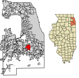 Location of Tinley Park in Cook and Will Counties, Illinois. | |
 Location of Illinois in the United States | |
| Coordinates: 41°34′26″N 87°48′14″W | |
| Country | United States |
| State | Illinois |
| Counties | Cook, Will |
| Townships | Cook: Bremen, Orland, Rich Will: Frankfort |
| Incorporated | 1892 |
| Government | |
| • Type | Council–manager |
| • Mayor | Michael W. Glotz [1] |
| Area | |
| • Total | 16.13 sq mi (41.78 km2) |
| • Land | 16.12 sq mi (41.75 km2) |
| • Water | 0.01 sq mi (0.03 km2) 0.12% |
| Population (2020) | |
| • Total | 55,971 |
| • Density | 3,472.15/sq mi (1,340.58/km2) |
| Standard of living (2009–11) | |
| • Per capita income | $31,576 |
| • Median home value | $244,500 |
| ZIP code(s) | 60477, 60478, and 60487 |
| Area code(s) | 708, 815 |
| Geocode | 75484 |
| FIPS code | 17-75484 |
| Website | www |
History
19th century
Settlement of the area which now comprises Tinley Park began in the 1820s by emigrants from the Eastern United States. German settlers became predominant in area by the 1840s, and the village was established in 1853. The Village was called Bremen at the time. Irish, English, Scottish, Canadian, and other American settlers were also common in the area.[4]
In the late 19th century, railroads expanded rapidly, and the village happened to be located on the Chicago, Rock Island and Pacific Railroad line. The influence of the railroad on Bremen was so great that, in 1890, its name was changed to Tinley Park in honor of the village's first railroad station agent, Samuel Tinley, Sr. Even the village's official incorporation took place at the train depot on June 27, 1892.
20th century
With the railroad came industry and commerce. 1905 saw the Diamond Spiral Washing Machine Company found its first factory in Tinley Park. Local businessmen established an electric utility in 1909. A bottling facility for pop was operated in Tinley Park until the 1950s. Inventor John Rauhoff developed and manufactured a waterproofing additive for cement called Ironite, later used in the construction of Hoover Dam. In 1956, a building was erected for the new Tinley Park Public Library. In the latter part of the 20th century, Tinley Park was, and remains to be, an area of rapid suburban expansion to the west and south of the original site, with over 11,000 housing units constructed between 1970 and 1994.[5]
Today
After its centennial (1992), Tinley Park from the late 20th century to the present has been focused on renovation of its downtown historic district. The historic district is made up of the village's original 1892 boundaries. In this district, landowners are encouraged to maintain the historic edifices or to create new, historically friendly facades for otherwise non-historic buildings built in the last 30 years.[citation needed]
Downtown renovation projects include the creation of a park near the Oak Park Avenue Metra train station, as well as the recent South Street Project, a multimillion-dollar project that will create more than 220 apartments and 40,000 square feet (4,000 m2) of commercial retail space.[citation needed]
The Hollywood Casino Amphitheatre (formerly named "The World Music Theater", "Tweeter Center Chicago", and until 2015, "First Midwest Bank Amphitheatre"),[6] an outdoor venue which seats 28,000, is located in Tinley Park.[7]
On February 2, 2008, a mass shooting occurred at Lane Bryant in Brookside Marketplace on the Will County side of the village. The store closed after the shooting.
Tinley Park was the site of the Tinley Park Lights, an anomalous multiple mass UFO sighting event in 2004, 2005 and 2006.[citation needed]
Geography
Tinley Park is located at 41°34′26″N 87°48′14″W (41.573800, −87.803891).[8]
According to the 2010 census, Tinley Park has a total area of 16.039 square miles (41.54 km2), of which 16.02 square miles (41.49 km2) (or 99.88%) is land and 0.019 square miles (0.05 km2) (or 0.12%) is water.[9] It is bordered by Oak Forest to the northeast, Orland Park to the northwest, Orland Hills and Mokena to the west, Country Club Hills to the east. Matteson to the southeast, Frankfort to the southwest and Frankfort Square to the south.
Demographics
| Historical population | |||
|---|---|---|---|
| Census | Pop. | %± | |
| 1900 | 300 | — | |
| 1910 | 309 | 3.0% | |
| 1920 | 493 | 59.5% | |
| 1930 | 823 | 66.9% | |
| 1940 | 1,136 | 38.0% | |
| 1950 | 2,326 | 104.8% | |
| 1960 | 6,392 | 174.8% | |
| 1970 | 12,572 | 96.7% | |
| 1980 | 26,178 | 108.2% | |
| 1990 | 37,121 | 41.8% | |
| 2000 | 48,401 | 30.4% | |
| 2010 | 56,703 | 17.2% | |
| 2020 | 55,971 | −1.3% | |
| U.S. Decennial Census[10] 2010[11] 2020[12] | |||
2020 census
| Race / Ethnicity | Pop 2010[11] | Pop 2020[12] | % 2010 | % 2020 |
|---|---|---|---|---|
| White alone (NH) | 47,858 | 43,852 | 84.40% | 78.35% |
| Black or African American alone (NH) | 2,062 | 3,540 | 3.64% | 6.32% |
| Native American or Alaska Native alone (NH) | 52 | 7 | 0.09% | 0.01% |
| Asian alone (NH) | 2,199 | 2,345 | 3.88% | 4.19% |
| Pacific Islander alone (NH) | 6 | 5 | 0.01% | 0.01% |
| Some Other Race alone (NH) | 29 | 129 | 0.05% | 0.23% |
| Mixed Race/Multi-Racial (NH) | 599 | 1,397 | 1.06% | 2.50% |
| Hispanic or Latino (any race) | 3,898 | 4,696 | 6.87% | 8.39% |
| Total | 56,703 | 55,971 | 100.00% | 100.00% |
Note: the US Census treats Hispanic/Latino as an ethnic category. This table excludes Latinos from the racial categories and assigns them to a separate category. Hispanics/Latinos can be of any race.
2010 Census
As of the 2010 census,[13] there were 56,703 people, 17,478 households, and 12,793 families residing in the village. The population density was 3,236.9 inhabitants per square mile (1,249.8/km2). There were 18,037 housing units at an average density of 1,206.2 per square mile (465.7/km2). The racial makeup of the village was 93.16% White, 1.92% African American, 0.13% Native American, 2.38% Asian, 0.02% Pacific Islander, 1.11% from other races, and 1.27% from two or more races. Hispanic or Latino of any race were 4.13% of the population.
The top five ancestries reported in Tinley Park as of the 2000 census were Irish (25.5%), German (23.1%), Polish (19.9%), Italian (14.3%) and Dutch (5.3%).[14]
There were 17,478 households, out of which 36.4% had children under the age of 18 living with them, 61.5% were married couples living together, 8.6% had a female householder with no husband present, and 26.8% were non-families. 23.1% of all households were made up of individuals, and 8.7% had someone living alone who was 65 years of age or older. The average household size was 2.73 and the average family size was 3.27.
In the village, the population was spread out, with 26.6% under the age of 18, 8.1% from 18 to 24, 31.0% from 25 to 44, 23.5% from 45 to 64, and 10.7% who were 65 years of age or older. The median age was 36 years. For every 100 females, there were 93.8 males. For every 100 females age 18 and over, there were 90.5 males.
The median income for a household in the village was $61,648, and the median income for a family was $71,858 (these figures had risen to $70,480 and $84,072 respectively as of a 2017 estimate[15]). Males had a median income of $50,595 versus $34,401 for females. The per capita income for the village was $25,207. About 1.1% of families and 2.5% of the population were below the poverty line, including 2.5% of those under age 18 and 3.6% of those age 65 or over.
Government
Tinley Park is divided between two congressional districts. Most of the village, including all the area in Bremen Township and Rich Township, as well as the area in Will County, is in Illinois's 1st congressional district; the area in Orland Township south of 167th Street, as well as most of the area southwest of 163rd Street and Ozark Avenue, is in the 3rd district.
Education
Tinley Park includes four public elementary school districts – Kirby School District 140, Community Consolidated School District 146, Summit Hill Elementary School District 161,[16] and Elementary School District 159.[17]
The town also includes three parochial Pre-K through 8 elementary schools: St. George, which is Catholic; Trinity Lutheran, affiliated with the LCMS; and Southwest Chicago Christian School of Tinley Park.[18]
Victor J. Andrew High School (Consolidated High School District 230) and Tinley Park High School (Bremen Community High School District 228) are both secondary schools located in Tinley Park. A small portion of Tinley Park students go to Lincoln-Way East High School. A small portion in the southwest part of the village also attends Rich Central High School.
Most residents of Tinley Park are located within the residency boundaries for Moraine Valley Community College; the rest reside in the community college district for South Suburban College. A very small portion of Tinley Park goes to Joliet Junior College.
Sister cities
Notable people
- Emil Andres, Indy and Sprint car driver
- Gary Bettenhausen, Indy and Sprint car driver
- Merle Bettenhausen, Sprint car driver
- Tony Bettenhausen, Indy car driver
- Tony Bettenhausen Jr., Indy car driver
- Miles Boykin, wide receiver for NFL's Pittsburgh Steelers
- Frank J. Christensen, labor leader
- Tevin Coleman, running back for NFL's San Francisco 49ers
- John Ericks, pitcher with Pittsburgh Pirates 1995–97
- Armando Estrada, former wrestler with WWE[citation needed]
- Nathan Everhart, wrestler with WWE
- Gina Glocksen, season six finalist on American Idol
- Michael Hastings, Illinois State Senator, 98th General Assembly
- Garrett Jones, outfielder, first baseman with Minnesota Twins, Pittsburgh Pirates, New York Yankees
- Stacie Juris, Miss Illinois Teen USA 2009 and Miss Illinois USA 2013
- Christine Magnuson, Olympic swimmer (two-time silver medalist)
- Real Friends, pop punk band
- Kevin Sefcik, utility player with Philadelphia Phillies and Colorado Rockies
- John J. Szaton, Polish-American sculptor and creator of Coal Miner
- Jeremiah Wright, former minister to Barack Obama
References
- "Tinley Park, IL – Official Website – Mayor". Tinleypark.org. Archived from the original on August 22, 2017. Retrieved August 22, 2017.
- "2020 U.S. Gazetteer Files". United States Census Bureau. Retrieved March 15, 2022.
- "Tinley Park village, Illinois". United States Census Bureau. Retrieved April 15, 2022.
- Archived February 29, 2012, at the Wayback Machine
- Bureau, U.S. Census. "American FactFinder – Results". Factfinder.census.gov. Archived from the original on February 10, 2020. Retrieved August 22, 2017.
- "Tinley Park music theater gets new name, again". Chicago Tribune. Retrieved January 25, 2015.
- "First Midwest Bank Amphitheatre". In Concert With You. First Midwest Bank. Retrieved May 17, 2013.
- "US Gazetteer files: 2010, 2000, and 1990". United States Census Bureau. February 12, 2011. Retrieved April 23, 2011.
- "G001 – Geographic Identifiers – 2010 Census Summary File 1". United States Census Bureau. Archived from the original on February 13, 2020. Retrieved December 25, 2015.
- "Decennial Census of Population and Housing by Decades". US Census Bureau.
- "P2 HISPANIC OR LATINO, AND NOT HISPANIC OR LATINO BY RACE – 2010: DEC Redistricting Data (PL 94-171) – Tinley Park village, Illinois". United States Census Bureau.
- "P2 HISPANIC OR LATINO, AND NOT HISPANIC OR LATINO BY RACE – 2020: DEC Redistricting Data (PL 94-171) – Tinley Park village, Illinois". United States Census Bureau.
- "U.S. Census website". United States Census Bureau. Retrieved January 31, 2008.
- Profile of Selected Social Characteristics, Tinley Park, Illinois Archived February 12, 2020, at archive.today. U.S. Census Bureau. Retrieved July 11, 2007.
- Bureau, U.S. Census. "American FactFinder – Community Facts". factfinder.census.gov. Archived from the original on February 11, 2020. Retrieved August 22, 2017.
- "Summit Hill School District 161 – Frankfort, Illinois". summithill.org.
- "About Our District Archived 2017-01-09 at archive.today." Elementary School District 159. Retrieved January 9, 2017.
- "Tinley Park Campus". Swchristian.org. Retrieved May 17, 2016.
External links
Municipalities and communities of Cook County, Illinois, United States | ||
|---|---|---|
County seat: Chicago | ||
| Cities |
|  |
| Towns |
| |
| Villages |
| |
| Townships |
Former: Evanston • Hyde Park • Jefferson • Lake • Lake View • North Chicago • Rogers Park • South Chicago • West Chicago | |
| Unincorporated communities | ||
| Footnotes | ‡This populated place also has portions in an adjacent county or counties | |
| ||
Municipalities and communities of Will County, Illinois, United States | ||
|---|---|---|
County seat: Joliet | ||
| Cities |
|  |
| Villages |
| |
| Townships | ||
| CDPs |
| |
| Other communities |
| |
| Ghost town | ||
| Footnotes | ‡This populated place also has portions in an adjacent county or counties | |
| ||
| Major city |
|  |
|---|---|---|
| Cities (over 30,000 in 2010) |
| |
| Towns and villages (over 30,000 in 2010) |
| |
| Counties | ||
| Regions |
| |
| Sub-regions |
| |
Illinois, United States | ||
Authority control | |
|---|---|
| General | |
| National libraries | |
| Other |
|
На других языках
[de] Tinley Park
Tinley Park ist ein Village in Illinois in den Vereinigten Staaten. Es liegt größtenteils im Cook County und zu einem kleineren Teil im Will County und ist Bestandteil der Metropolregion Chicago.- [en] Tinley Park, Illinois
Другой контент может иметь иную лицензию. Перед использованием материалов сайта WikiSort.org внимательно изучите правила лицензирования конкретных элементов наполнения сайта.
WikiSort.org - проект по пересортировке и дополнению контента Википедии