world.wikisort.org - USA
Boulder Creek is a small rural mountain community in the coastal Santa Cruz Mountains. It is a census-designated place (CDP) in Santa Cruz County, California, with a population of 5,429 as of the 2020 census. Throughout its history, Boulder Creek has been home to a logging town and a resort community, as well as a counter-culture haven. Today, it is identified as the gateway town to Big Basin Redwoods State Park.
Boulder Creek | |
|---|---|
Census-designated place | |
 Looking north from Highway 9 at the Boulder Creek Hardware building and the 70-foot long painted mural by John Ton, depicting two phases of the town's history. | |
| Nickname(s): Emerald of the San Lorenzo, Phoenix of the Mountains | |
 Interactive map outlining Boulder Creek | |
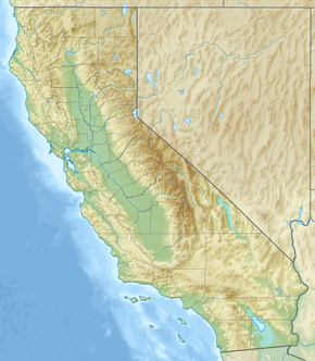 Boulder Creek Location within California  Boulder Creek Location within the United States  Boulder Creek Location within North America  Boulder Creek Boulder Creek (Earth) | |
| Coordinates: 37°7′53″N 122°7′28″W | |
| Country | United States |
| State | California |
| County | Santa Cruz |
| Founded | 1868[1] |
| Named for | Boulder Creek |
| Government | |
| • Body | Board of Supervisors |
| • Supervisor[2] | Bruce McPherson (I) |
| • Assembly Member[3][4] | Mark Stone (D) |
| • State Senator[4] | John Laird (D) |
| • United States Representative[5][6] | Anna Eshoo (D) |
| Area | |
| • Total | 7.51 sq mi (19.46 km2) |
| • Land | 7.51 sq mi (19.46 km2) |
| • Water | 0.00 sq mi (0.00 km2) 0% |
| Elevation | 479 ft (146 m) |
| Highest elevation | 2,694 ft (821 m) |
| Lowest elevation | 324 ft (99 m) |
| Population (2020)[9] | |
| • Total | 5,429 |
| • Density | 722.71/sq mi (279.04/km2) |
| Time zone | UTC– 08:00 (PST) |
| • Summer (DST) | UTC– 07:00 (PDT) |
| ZIP code | 95006 |
| Area code | 831 |
| FIPS code | 06-07652 |
| GNIS feature ID | 277478 |
History
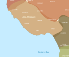
The Boulder Creek area is in the traditional tribal territory of the Awaswas people,[10] of which there are no living survivors and are spoken for by the Amah Mutsun Tribal Band.[11] According to one anthropologist, the indigenous name for the area was Achista and tentatively included Acsaggi.[10][12] The cultural unit, Ohlone, to which the Boulder Creek natives belonged were part of a contiguous set of bands that inhabited the coastal region of present-day California from the San Francisco Bay to the Monterey Peninsula and down to San José and Salinas Valley.[12][13]
The earliest European presence in the area was a Spanish exploratory party in 1769, led overland from Mexico by Don Gaspar de Portolá and Father Juan Crespí. On August 28, 1791, a Spanish mission, Mission Santa Cruz, was established by the Franciscans from Mission Santa Clara de Asís[14] for the conversion of the Awaswas. The Awaswas were moved to Mission Santa Cruz and Mission San Juan Bautista, which claimed the land and peoples. The Awaswas language and its dialects became the main language spoken at Mission Santa Cruz.
Upon independence from Spain in 1821, the area became a part of Mexico. Although Spain had not awarded land grants in the Santa Cruz area, the Mexican government started issuing them in 1822 when it took over the administration of California. Most of the grants lay along the coast, with the only ones within the San Lorenzo Valley being Rancho Zayante and Rancho San Agustin.[14] Under Mexican administration, only natural citizens could own land. Although not a Mexican citizen, in 1841, Isaac Graham purchased the Rancho Zayante land grant by proxy from frontiersman and naturalized Mexican citizen Joseph Ladd Majors.[14] In 1843, together with Peter Lassen, Graham built one of the first water-powered sawmills in California and, with it, the first significant settlement in the area. Graham's settlement marked the beginning of San Lorenzo Valley's lumber-based economy.
Following the Mexican-American War of 1846–48 and the California Gold Rush of 1848, the area steadily grew in population, including considerable immigration. While the Treaty of Guadalupe Hidalgo ending the War obliged the United States to honor Mexican land grants,[15] the process took many years of court hearings. In the meantime, squatters and entrepreneurs moved into the valley to harvest its rich resources of timber and lime. Despite the lack of roads, many families braved the wilderness to homestead the upper San Lorenzo. There were few large operations in the upper San Lorenzo Valley, leading the pioneers to develop their own systems of harvesting and transporting to the lumber and tanning markets.[14] Logging in the valley supplied large timbers to shore up the underground workings of the mines after the initial rush of gold-panning gave way to other mining techniques.[1] By the late 1850s, early settlers and lumbermen were using the Turkey Foot floodplain as a gathering point for their mule and oxen teams.[16]
Timber town
Branciford Alcorn was one of the first to settle along Bear Creek in 1865. Daniel Crediford and sons Wilfred and Stephen moved about four miles up Boulder Creek to the Sequoia district in 1867.[14] West Virginian Joseph Wilbur Peery also settled in the Boulder area in 1867 and began a small-scale logging project along the San Lorenzo River. Peery built a dam across the river at Two Bar Creek to provide water power to his mill and for the one he later built two miles south of the junction of the river, Boulder and Bear creeks.[16][17] Twin brothers Austin and Oscar Harmon assisted at the Two Bar Creek mill until its closure.[16] The erection of the Two Bar Creek sawmill by Peery later helped in the establishment of the settlement of Boulder.
The year 1868 was the founding year for the settlement of Boulder.[1] Transportation remained a problem, slowing development of the small communities that now dotted the valley. A road extension from Graham Hill Road linking the upper San Lorenzo valley with Santa Cruz through Felton was completed in May. It also marked the completion of the United States government's survey of all land not held by grants in the Santa Cruz Mountains, which was then opened for purchase and homesteading. Government surveyors divided the largely unsettled San Lorenzo Valley into claimable sections. The area of Boulder Creek occupied two 160-acre tracts. The northern half, between Harmon and Bear Creeks, was awarded to John Alcorn, Branciford's son.[18] Loggers moved up the San Lorenzo and its tributaries removing every marketable tree[14] that were then sold to the demanding market of the San Francisco Bay area. The lumbermen and their families moved into scattered cottages and homes around the periphery of Peery's Two Bar Creek sawmill, while a general store, livery stable, and blacksmith shop arose nearby to support the mill and its visitors.[16] The increase in the number of families with children determined the need for a school, the first one of which was started in a small building on Alcorn's land[18] on what is now West Park Drive.[14]
Lumber could not be shipped over the mountains to Santa Clara Valley. Two years later in 1871, another road extension, the Saratoga Toll Road, was added from the summit at the Saratoga Gap and ran 11 miles to meet the road that ran about four miles above Boulder Creek.[14][19] In June, the Maclay Turnpike officially opened. Alcorn erected a two-story boarding house, the Boulder Creek House.[16][18] That same year, Peery was awarded a land grant[19] and relocated his lumber mill a mile south to Lorenzo, a settlement that he laid out, which was bounded by what is now Harmon, West, South, and East Streets.[16] With an access point to the greater San Francisco Bay Area came the establishment of a post office named Boulder Creek in 1872, with Peery becoming the first Postmaster.[20] Mail runs were limited to twice a week because it took a mail carrier two days to travel from Santa Clara to Felton.[19][16]
What is now Boulder Creek was originally once two settlements: Lorenzo at the southern end of town, and Boulder was north of the current town core.
Boulder Creek served as the upper terminus of the San Lorenzo Valley Logging Flume terminating in Felton, which began construction in 1874 and, when formally opened in October 1875, was augmented by a new rail line to transport logs to the wharf in Santa Cruz.[19] In the 1880s, this lumber town which was called Lorenzo took the name of the Boulder Creek post office that had been established in the 1870s.[21]

Geography
Boulder Creek is located on the West Coast of the United States. The town has a total area of 7.5 square miles (19 km2), of which all is land. The town is bordered by San Mateo County to the northwest; Santa Clara County to the northeast; Big Basin Redwoods State Park to the west; and Brookdale to the south. Boulder Creek is 15 miles (24 km) from Santa Cruz, 30 miles (48 km) from San Jose, 70 miles (110 km) from San Francisco, and 150 miles (240 km) from Sacramento.
Boulder Creek sits at the north end of the San Lorenzo Valley at the confluence of San Lorenzo River and Boulder Creek within the Santa Cruz Mountains, a Level IV ecoregion designated by the United States Environmental Protection Agency (EPA), an area surrounded by steep, redwood- and pine- covered hills formed by the river, creek, and their tributaries. The river flows through Boulder Creek on the east and south through Brookdale, Ben Lomond, and Felton, and continues south to the City of Santa Cruz where it enters Monterey Bay.[22] Directly across from Boulder Creek's confluence with the San Lorenzo River, Bear Creek flows into the river and creates a topographical feature known as the Turkey Foot. The Turkey Foot creates a floodplain, particularly on the western side of the river where the mountainside is less steep.
Climate
Boulder Creek has a warm-summer Mediterranean climate (Köppen Csb) characteristic of California's coast, with moist, mild winters and dry summers. Located about 15 miles inland, the Boulder Creek skies can be overcast due to moisture from the Pacific Coast marine layer.
The dry period of May to October is mild to warm, with the normal monthly mean temperature peaking in August at 81.0 °F (27.2 °C). The rainy period of November to April is slightly cooler, with the normal monthly mean temperature reaching its lowest in December at 38.0 °F (3.3 °C). On average, there are 75 rainy days a year, and annual precipitation averages 36.0 inches (914 mm). Variation in precipitation from year to year is high. Above-average rain years are often associated with warm El Niño conditions in the Pacific while dry years often occur in cold water La Niña periods.[23]
Flooding of the San Lorenzo River, caused by a combination of high tide, storm surge, and runoff, has been known to cause extensive damage. During the January 1982 El Niño storm, from January 3 to 4, 12.74 inches of rainfall occurred in Boulder Creek over the period of 24 hours. This generated debris flows and shallow landslides. During the El Niño winter of 1996 and 1997, higher concentrations of debris flows was observed in the area around Boulder Creek.[24]
Fires have occurred throughout Boulder Creek's history for various reasons but recently because of climate change. The CZU Lightning Complex fires started on August 16, 2020 due to a severe thunderstorm that initially started several separate fires. Due to a change in wind conditions, these separate fires merged together and rapidly spread through nearby communities, including Boulder Creek. The CZU fire incident was finally contained on September 22, after destroying a number of houses but sparing the town's historic main street.[25] Previously, two conflagration-sized fires nearly destroyed downtown Boulder Creek and the nearby village of Lorenzo in 1891.
Boulder Creek falls under the USDA 9b Plant hardiness zone.[26]
Cityscape

California State Route 9 enters Boulder Creek from the south at River Street, bisecting the town as the Central Avenue arterial thoroughfare, before passing by Bear Creek Road to the northeast and becoming SR 9 once again. Within the town core, Route 9 connects to the southern terminus of California State Route 236 with an at-grade intersection, which provides access to the northwest of the town as Big Basin Way. Route 236 then continues westward from Boulder Creek and into Big Basin Redwoods State Park.
The community is divided into three geographical sections of unequal size: Village Core, South Village, and Outlying Village Areas.[22]
Architecture
The architecture of Boulder Creek varies but is generally popular among tourists and locals. Many of the commercial buildings along Central Avenue are designed primarily in the Boomtown style. Historic buildings are designed primarily in the Queen Anne and a variety of Victorian styles. For examples, the designs of the McLeod House and the Stagg/Hartman House are drawn from these architectural movements. Modern and other non-classical architectural styles, such as Minimal Traditional and Ranch, are also seen throughout the community. Outside downtown Boulder Creek, architectural styles are even more varied. The former Grace Episcopal Church is designed in the Gothic Revival style.
Demographics
| Year | Pop. | ±% |
|---|---|---|
| 1890 | 489 | — |
| 1905 | 800[27] | +63.6% |
| 1910 | 1,018[27] | +27.2% |
| 1950 | 1,497 | +47.1% |
| 1960 | 1,306 | −12.8% |
| 1970 | 1,806 | +38.3% |
| 1980 | 5,662 | +213.5% |
| 1990 | 6,725 | +18.8% |
| 2000 | 4,081 | −39.3% |
| 2010 | 4,923 | +20.6% |
| 2020 | 5,429 | +10.3% |
| U.S. Decennial Census[28] 2010–2020[9] | ||
The 2020 United States census showed Boulder Creek's population to be 5,429, an increase of 10.3% from the 2010 census.
As of the 2020 census, the racial makeup and population of Boulder Creek included: 4,142 Whites (76.3%), 411 Multiracial Americans (7.6%), 117 Asians (2.2%), 28 African Americans (0.5%), 22 Native Americans and Alaska Natives (0.4%), 12 Native Hawaiians and other Pacific Islanders (0.3%), and 61 persons of other races (1.5%). There were 636 Hispanic or Latinos of any race (15.4%).
2010 Census data
The 2010 United States Census[29] reported that Boulder Creek had a population of 4,923. The population density was 655.4 inhabitants per square mile (253.1/km2). The racial makeup of Boulder Creek was 4,429 (90.0%) White, 54 (1.1%) African American, 31 (0.6%) Native American, 81 (1.6%) Asian, 5 (0.1%) Pacific Islander, 119 (2.4%) from other races, and 204 (4.1%) from two or more races. Hispanic or Latino of any race were 366 persons (7.4%).
The Census reported that 100% of the population lived in households.
There were 2,124 households, out of which 548 (25.8%) had children under the age of 18 living in them, 997 (46.9%) were opposite-sex married couples living together, 176 (8.3%) had a female householder with no husband present, 97 (4.6%) had a male householder with no wife present. There were 189 (8.9%) unmarried opposite-sex partnerships, and 29 (1.4%) same-sex married couples or partnerships. 598 households (28.2%) were made up of individuals, and 129 (6.1%) had someone living alone who was 65 years of age or older. The average household size was 2.32. There were 1,270 families (59.8% of all households); the average family size was 2.80.
The population was spread out, with 884 people (18.0%) under the age of 18, 319 people (6.5%) aged 18 to 24, 1,222 people (24.8%) aged 25 to 44, 2,066 people (42.0%) aged 45 to 64, and 432 people (8.8%) who were 65 years of age or older. The median age was 45.4 years. For every 100 females, there were 105.2 males. For every 100 females age 18 and over, there were 104.3 males.
There were 2,455 housing units at an average density of 326.8 per square mile (126.2/km2), of which 71.6% were owner-occupied and 28.4% were occupied by renters. The homeowner vacancy rate was 2.1%; the rental vacancy rate was 6.5%. 74.0% of the population lived in owner-occupied housing units and 26.0% lived in rental housing units.
2000 Census data
As of the census[30] of 2000, there were 4,081 people, 1,630 households, and 1,025 families residing in the CDP. The population density was 963.3 inhabitants per square mile (371.9/km2). There were 1,829 housing units at an average density of 431.7 per square mile (166.7/km2). The racial makeup of the CDP was 90.25% White, 0.59% African American, 1.10% Native American, 1.72% Asian, 0.20% Pacific Islander, 2.18% from other races, and 3.97% from two or more races. Hispanic or Latino of any race were 5.68% of the population.
There were 1,630 households, of which 31.8% had children under the age of 18 living with them, 48.1% were married couples living together, 10.1% had a female householder with no husband present, and 37.1% were non-families. 25.6% of all households were made up of individuals, and 4.2% had someone living alone who was 65 years of age or older. The average household size was 2.50 and the average family size was 3.02.
In the CDP, the population was spread out, with 23.6% under the age of 18, 7.9% from 18 to 24, 33.8% from 25 to 44, 28.7% from 45 to 64, and 6.0% who were 65 years of age or older. The median age was 38 years. For every 100 females, there were 101.1 males. For every 100 females age 18 and over, there were 101.6 males.
The median income for a household in the CDP was $60,455, and the median income for a family was $66,037. Males had a median income of $48,125 versus $40,197 for females. The per capita income for the CDP was $32,012. About 1.9% of families and 8.0% of the population were below the poverty line, including 0.9% of those under age 18 and 7.4% of those age 65 or over.
Economy
The area's economy was historically based on the timber and lime industries, but now relies on tourism. As the closest town to Big Basin Redwoods State Park, Boulder Creek provides services to some of Big Basin's visitors. Many of its current residents are retirees, families and professionals who commute to nearby jobs.
Culture
Museums
The San Lorenzo Valley Museum is an educational foundation that maintains two of the area's official museums. The California Humanities and the National Endowment for the Humanities (NEH) partially fund the Museum, and its permanent and temporary exhibits are open to the public free of charge. Its main gallery is in Boulder Creek, which is housed in the former Grace Episcopal Church, a historical landmark listed on the National Register of Historic Places. The other location is the Faye G. Belardi Memorial Gallery in Felton.
Festivals and street fairs
Boulder Creek is home to several different and unique street festivals, parties, and parades. Most famous are its Fourth of July Parade and Lumberjack Days held every July; Halloween Sidewalk Party in October; and Christmas in the Redwoods in November. The Boulder Creek Art, Wine, and Music Festival was previously held every Memorial Day Weekend on Central Avenue for more than 20 years; it has continued as the Santa Cruz Mountain Art and Wine Festival and is held every Labor Day Weekend at Garrahan Park.
Government
Boulder Creek is an unincorporated[31] community, a status it has held since being dis-incorporated during the 1915[32] session of the California State Legislature. While Boulder Creek is not governed at the municipal level, it does consist of a number of entities to support its needs. Its executive and legislative governing body is the Santa Cruz County Board of Supervisors[33] and in the county-wide elections, Boulder Creek forms part of District Five. The Board acts in place of a city council. Because of its unincorporated status, Santa Cruz County provides land use planning, parks, public works, and economic development services and regulation.[34]
In the California State Legislature, Boulder Creek is in the 17th Senate District and in the 29th Assembly District.
In the United States House of Representatives, Boulder Creek is in California's 18th congressional district.
Departments and agencies
Independent and semi-independent entities include the:
- Boulder Creek Business Association
- Boulder Creek Fire Protection District
- Boulder Creek Recreation and Park District
Education
San Lorenzo Valley Unified School District (SLVUD), the sole public school district in the town, operates the town's single public elementary school, Boulder Creek Elementary. In the 2021-22 school year, 445 students were enrolled in the public elementary school.[35] From sixth to twelfth grades, Boulder Creek students attend San Lorenzo Valley Middle and High Schools, both located in Felton.
The town is also home to three private schools (PK, PK-K, 1-12), one of which is a Montessori Teacher-run pre-school, and one public charter school (K-12). Santa Cruz Public Libraries operates one neighborhood location, the Boulder Creek Branch Library.
Media
KBCZ is a non-profit, community-based radio station broadcasting, since receiving its license in June 2013, from the Boulder Creek Recreation and Park District's Visitor Center office in downtown Boulder Creek. The FCC granted extended coverage in 2021 and KBCZ now covers all of the San Lorenzo Valley, Scotts Valley, Lompico and parts of Santa Cruz.
Notable people
- Michael Been - musician; resident
- Aric Cushing – actor, director, author[36]
- Cora Evans – Catholic mystic;[37] resident
- Jonathan Franzen – author; resident for several years
- Nick Herbert – physicist and author;[38] resident
- Christopher Hills - author; resident
- Jordan Hubbard - FreeBSD co-founder; resident
- Paul Locatelli - Jesuit priest and academic; born in Boulder Creek
- Martan Mann - jazz pianist, educator, author; resident
- Tom Pepper – Nullsoft co-founder; resident
- Samuel H. Rambo – California State Senator; resident
See also
- Ahlgren Vineyard
- DigiBarn Computer Museum
References
- "Boulder Creek: The end of the line's beginning". PressBanner. Retrieved 2022-08-01.
“We use the year 1868 as the year of Boulder Creek’s founding,” said Lynda Phillips, the executive director of San Lorenzo Valley Historical Museum. While people were here before that and the railroad came after, 1868 is when the first school was built. “And we decided what really makes a town a town is when people decide this is where to raise and educate their children,” Phillips explained.
- "Board of Supervisors". County of Santa Cruz. Retrieved 2022-08-01.
- "Members Assembly". California State Assembly. Retrieved 2022-08-01.
- "Statewide Database". UC Regents. Retrieved October 8, 2014.
- "Directory of Representatives". U.S. House of Representatives.
- "California's 18th Congressional District - Representatives & District Map". Civic Impulse, LLC. Retrieved 2022-08-01.
- "2020 U.S. Gazetteer Files". United States Census Bureau. Retrieved October 30, 2021.
- "Boulder Creek". Geographic Names Information System. United States Geological Survey, United States Department of the Interior. Retrieved 2022-08-01.
- "QuickFacts: Boulder Creek, California". United States Census Bureau. Retrieved August 1, 2022.
- Milliken, Randall. (1995). A Time of Little Choice: The Disintegration of Tribal Culture in the San Francisco Bay Area 1769–1910. Ballena Press Publication, Menlo Park, CA. ISBN 0-87919-132-5.
- Severn, Cathy (July 20, 2022). "As Big Basin Finally Reopens, Indigenous Stewardship Key Among Plans for Park's Rebirth". Retrieved 2022-08-02.
- Bean, Lowell John, ed. (1994). Ohlone Past and Present. Ballena Press anthropological papers. Menlo Park, CA: Ballena Press. ISBN 978-0-87919-130-6.
- Dunn, Geoffrey (2013-05-08). "Spirit Weavers". Good Times Santa Cruz. Retrieved 2022-08-03.
- McCarthy, Nancy F. (1994). Where Grizzlies Roamed the Canyons (PDF). Garden Court Press, Palo Alto, CA. ISBN 1-880732-12-2.
- Rawls, James J. (1999). A Golden State: Mining and Economic Development in Gold Rush California. University of California Press, Berkeley, CA. ISBN 0-520-21770-5.
- Whaley, Derek R. (2015). Santa Cruz Trains: Railroads of the Santa Cruz Mountains. CreateSpace Independent Publishing Platform. ISBN 978-1508570738.
- Sawyer, Eugene T. (1922). History of Santa Clara County, California. Historic Record Co., Los Angeles, CA. ISBN 978-3849678470.
- Brown, Randall (January 4, 2021). "History: Woman With A Past". Retrieved 2022-08-11.
- Robinson, Lisa A. (2012). Images of America: The San Lorenzo Valley. Acadia Publishing, Charleston, SC. ISBN 9780738592299.
- "New Boulder Creek Postmaster Takes Oath of Office". United States Postal Service. Retrieved 2022-08-11.
- Gudde, Erwin G. (1998). California Place Names: The Origin and Etymology of Current Geographical Names (4th ed., rev. and enl. ed.). Berkeley: University of California Press. p. 44. ISBN 0520213165.
- "Boulder Creek Town Plan" (PDF). sccoplanning.com. Retrieved August 2, 2022.
- Climate in Boulder Creek, California Sperling's Best Places. Retrieved August 11, 2022.
- "Watershed Emergency Response Team Evaluation: CZU Lightning Complex" (PDF). smcgov.org. Retrieved October 27, 2022.
- Andre, Drew (August 26, 2020). "Boulder Creek neighborhood destroyed in CZU lightning Complex". Retrieved 2022-08-01.
- "California Interactive USDA Plant Hardiness Zone Map". Retrieved 2022-08-01.
- "NPS Form 10-900a, Section 8, Page 3". Retrieved 2022-09-02.
- "Census of Population and Housing". Census.gov. Retrieved 2022-08-01.
- "2010 Census Interactive Population Search: CA – Boulder Creek CDP". U.S. Census Bureau. Archived from the original on July 15, 2014. Retrieved July 12, 2014.
- "U.S. Census website". United States Census Bureau. Retrieved 2008-01-31.
- "Santa Cruz County Fact Sheet: Unincorporated Areas". Visit Santa Cruz County. Retrieved 2022-07-31.
- Sigmund, Wendy (June 3, 2022). "Reading Room Roots- a Brief History of the Boulder Creek Branch Library". Retrieved 2022-08-02.
- "About the Board". County of Santa Cruz. County of Santa Cruz. 2022. Retrieved August 2, 2022.
- "Santa Cruz County Governments". Santa Cruz County Chamber of Commerce. Retrieved 2022-08-01.
- "Boulder Creek Elementary". Education Data Partnership. Retrieved 2022-09-01.
- "Aric Cushing: Biography". IMDb. Retrieved 2022-08-01.
- Emmons, Mark (August 12, 2016) [September 24, 2013]. "Vatican considering Santa Cruz Mountains mystic for sainthood". San Jose Mercury News.
- Kaiser, David (2012). How the Hippies Saved Physics: Science, Counterculture, and the Quantum Revival. New York: Norton. ISBN 9780393342314.
External links
- Boulder Creek Business Association
- Boulder Creek Fire Protection District
- Boulder Creek Recreation and Park District
- San Lorenzo Valley Museum
- Big Basin Vineyards
- Santa Cruz Mountain Bulletin
- Unofficial website – Outdated since 2011.
Municipalities and communities of Santa Cruz County, California, United States | ||
|---|---|---|
County seat: Santa Cruz | ||
| Cities |  | |
| CDPs | ||
| Unincorporated communities |
| |
| Ghost town | ||
| ||
Monterey Bay Area | ||
|---|---|---|
| Bodies of water & submarine features |  | |
| Counties | ||
| Major cities | ||
| Cities and towns 50k-100k | ||
| Cities and towns 25k-50k | ||
| Cities, towns, and census-designated places <25k | ||
| Ghost Towns | ||
| ||
State of California | |
|---|---|
Sacramento (capital) | |
| Topics |
|
| Regions |
|
| Metro regions |
|
| Counties |
|
| Most populous cities | |
Authority control | |
|---|---|
| General | |
| National libraries | |
| Other |
|
Другой контент может иметь иную лицензию. Перед использованием материалов сайта WikiSort.org внимательно изучите правила лицензирования конкретных элементов наполнения сайта.
WikiSort.org - проект по пересортировке и дополнению контента Википедии