world.wikisort.org - USA
Montecito (Spanish for "Little mountain") is an unincorporated town and census-designated place in Santa Barbara County, California.[6][7] Located on the Central Coast of California, Montecito sits between the Santa Ynez Mountains and the Pacific Ocean and had a population of 8,638 in 2020. Montecito is best known as a "celebrity enclave", owing to its concentration of prominent residents.[8]
Montecito, California | |
|---|---|
Census designated place | |
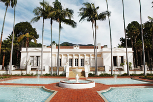
     Clockwise: view of Montecito and the Pacific Ocean from the Santa Ynez Mountains; Our Lady of Mount Carmel Church; Lotusland; Butterfly Beach; Casa del Herrero. | |
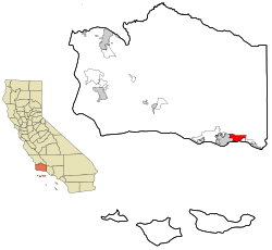 Location in Santa Barbara County and the state of California | |
 Montecito, California Location in the United States  Montecito, California Montecito, California (California)  Montecito, California Montecito, California (the United States) | |
| Coordinates: 34°26′N 119°38′W | |
| Country | United States |
| State | California |
| County | Santa Barbara |
| Government | |
| • State senator | Monique Limón (D)[1] |
| • Assembly Member | Steve Bennett (D)[1] |
| • U. S. rep. | Salud Carbajal (D)[2] |
| Area | |
| • Total | 9.265 sq mi (23.994 km2) |
| • Land | 9.259 sq mi (23.979 km2) |
| • Water | 0.006 sq mi (0.014 km2) 0.06% |
| Elevation | 180 ft (55 m) |
| Population (April 1, 2020)[5] | |
| • Total | 8,638 |
| • Density | 930/sq mi (360/km2) |
| Time zone | UTC−8 (Pacific) |
| • Summer (DST) | UTC−7 (PDT) |
| ZIP Codes | 93108, 93150 |
| Area code | 805 and 820 |
| FIPS code | 06-48844 |
| GNIS feature IDs | 1661052, 2408861 |
History


The site of present-day Montecito, along with the entire south coast of Santa Barbara County, was inhabited for over 10,000 years by the Chumash Indians. The Spanish arrived in the 18th century but left the region largely unsettled while they built the Presidio and Mission Santa Barbara farther west.
In the middle of the 19th century, the area was known as a haven for bandits and highway robbers, who hid in the oak groves and canyons, preying on traffic on the coastal route between the towns that developed around the missions. By the end of the 1860s, the bandit gangs were gone, and Italian settlers arrived. Finding an area reminiscent of Italy, they built farms and gardens similar to those they had left behind.
Around the end of the 19th century, wealthy tourists from the eastern and midwestern United States began to buy land in the area.[9] It was near enough to Santa Barbara for essential services while still being secluded. Desirable weather and several nearby hot springs offered the promise of comfortable, healthy living, in addition to the availability of affordable land.[10]
The Montecito Hot Springs Hotel was built near the largest of the springs, in a canyon north of the town center and directly south of Montecito Peak, in Hot Springs Canyon. The hotel burned down in 1920; it was replaced a few years later by the smaller Hot Springs Club.[11]
The architect George Washington Smith is noted particularly for his residences around Montecito, and for popularizing the Spanish Colonial Revival style in early 20th century America, as is Lutah Maria Riggs, who started as a draftsman in Smith's firm, rose to partner, and later started her own firm.[12]
Montecito was evacuated five times in four months between December 2017 and March 2018 because of weather-related events, which included the Thomas Fire, the 2018 Southern California mudflows, and flooding related to the Pineapple Express.[13] The mudflows resulted in 20 reported deaths; 28 others were injured, and at least four people[14] were reported missing.[15][16][17][18] FEMA gave the Santa Barbara County Flood Control District $13.5 million dollars in 2020. The funds will be used to buy land in Montecito to construct an $18 million dollar project that will help control debris flows from San Ysidro Creek with a larger debris basin.[19]
Geography

According to the United States Census Bureau, the CDP has a total area of 9.3 square miles (24 km2), 99.94% of it land and 0.06% of it water.
March and April are the months to watch gray whales migrate north from Mexico through the Santa Barbara Channel.[20] The community provides access to backcountry hiking trails.[21]
Climate
Montecito experiences a warm Mediterranean climate (Köppen climate classification Csb) characteristic of coastal Southern California. Because of Montecito's proximity to the ocean, onshore breezes significantly moderate temperatures, resulting in warmer winters and cooler summers compared with places further inland. With its gentle Mediterranean climate, Montecito has long been a desirable location for horticulturists.
| Climate data for Montecito, California | |||||||||||||
|---|---|---|---|---|---|---|---|---|---|---|---|---|---|
| Month | Jan | Feb | Mar | Apr | May | Jun | Jul | Aug | Sep | Oct | Nov | Dec | Year |
| Record high °F (°C) | 88 (31) |
88 (31) |
92 (33) |
100 (38) |
101 (38) |
109 (43) |
109 (43) |
102 (39) |
107 (42) |
103 (39) |
97 (36) |
83 (28) |
109 (43) |
| Average high °F (°C) | 64 (18) |
65 (18) |
66 (19) |
70 (21) |
70 (21) |
74 (23) |
77 (25) |
78 (26) |
77 (25) |
75 (24) |
70 (21) |
65 (18) |
71 (22) |
| Average low °F (°C) | 43 (6) |
45 (7) |
47 (8) |
49 (9) |
52 (11) |
55 (13) |
58 (14) |
59 (15) |
57 (14) |
53 (12) |
47 (8) |
43 (6) |
51 (11) |
| Record low °F (°C) | 24 (−4) |
25 (−4) |
32 (0) |
36 (2) |
38 (3) |
42 (6) |
48 (9) |
47 (8) |
43 (6) |
36 (2) |
30 (−1) |
20 (−7) |
20 (−7) |
| Average precipitation inches (mm) | 3.80 (97) |
4.34 (110) |
3.34 (85) |
0.72 (18) |
0.30 (7.6) |
0.08 (2.0) |
0.02 (0.51) |
0.04 (1.0) |
0.29 (7.4) |
0.53 (13) |
1.37 (35) |
2.36 (60) |
17.19 (437) |
| Source: [22] | |||||||||||||
Demographics
2010

The 2010 United States Census[23] reported that Montecito had a population of 8,965. The population density was 967.7 inhabitants per square mile (373.6/km2). The racial makeup of Montecito was 8,267 (92.2%) White, 55 (0.6%) African American, 38 (0.4%) Native American, 218 (2.4%) Asian, 6 (0.1%) Pacific Islander, 156 (1.7%) from other races, and 225 (2.5%) from two or more races. Hispanic or Latino of any race were 605 persons (6.7%).
The Census reported that 8,033 people (89.6% of the population) lived in households, 932 (10.4%) lived in non-institutionalized group quarters, and none were institutionalized.
Of the 3,432 households, 831 (24.2%) had children under the age of 18 living in them; 1,936 (56.4%) were opposite-sex married couples living together, 234 (6.8%) had a female householder with no husband present, 93 (2.7%) had a male householder with no wife present. There were 110 (3.2%) unmarried opposite-sex partnerships, and 36 (1.0%) same-sex married couples or partnerships. 941 households (27.4%) were made up of individuals, and 527 (15.4%) had someone living alone who was 65 years of age or older. The average household size was 2.34. There were 2,263 families (65.9% of all households); the average family size was 2.79.
The age spread of the population accounts 1,515 people (16.9%) under the age of 18, 1,234 people (13.8%) aged 18 to 24, 1,169 people (13.0%) aged 25 to 44, 2,716 people (30.3%) aged 45 to 64, and 2,331 people (26.0%) who were 65 years of age or older. The median age was 50.0 years. For every 100 females, there were 87.3 males. For every 100 females age 18 and over, there were 83.9 males.
4,238 housing units represented an average density of 457.5 per square mile (176.6/km2), of which 2,522 (73.5%) were owner-occupied, and 910 (26.5%) were occupied by renters. The homeowner vacancy rate was 2.4%; the rental vacancy rate was 8.7%. 6,081 people (67.8% of the population) lived in owner-occupied housing units and 1,952 people (21.8%) lived in rental housing units.
2000
![The Casa del Herrero, designed by architect George Washington Smith in 1925, is often considered to be one of the finest examples of Spanish Colonial Revival architecture in California.[24]](http://upload.wikimedia.org/wikipedia/commons/d/dd/Santa_Barbara_007_%288413450566%29_%28cropped%29.jpg)
The census[25] of 2000 counted 10,000 people, 3,686 households, and 2,454 families residing in the census-designated place (CDP). The population density was 1,072.3 inhabitants per square mile (414.0/km2). There were 4,193 housing units at an average density of 449.6 per square mile (173.6/km2). The racial makeup of the CDP was 94.0% White, 0.5% African American, 0.3% Native American, 1.3% Asian, 0.2% Pacific Islander, 2.1% from other races, and 1.5% from two or more races. Hispanic or Latino of any race were 5.2% of the population.
Out of the total of 3,686 households, 25.7% had children under the age of 18 living with them, 57.1% were married couples living together, 7.2% had a female householder with no husband present, and 33.4% were non-families. 27.0% of all households were made up of individuals, and 14.0% had someone living alone who was 65 years of age or older. The average household size was 2.41 and the average family size was 2.85.
The CDP population age distribution was 18.4% under the age of 18, 13.5% from 18 to 24, 16.6% from 25 to 44, 30.0% from 45 to 64, and 21.5% who were 65 years of age or older. The median age was 46 years. For every 100 females, there were 84.7 males. For every 100 females age 18 and over, there were 82.1 males.
The median income for a household in the CDP was $110,669, and the median income for a family was $130,123. Males had a median income of $81,719 versus US$42,182 for females. The per capita income for the CDP was $70,077. About 2.3% of families and 3.8% of the population were below the poverty line, including 2.6% of those under age 18 and 2.2% of those age 65 or over.
Government

As an unincorporated area of Santa Barbara County, Montecito has no city government.[26] Residents must rely on the county government for all municipal services.[26] Instead of voting for a city council, all of Montecito's residents are represented by only one of the five seats on the county board of supervisors.[26] Unlike other unincorporated areas in the county, Montecito does have two government agencies which together act as its planning commission: the Montecito Board of Architectural Review and the Montecito Planning Commission.[26] Municipal incorporation is a perennially recurring issue in local politics, but has never come to fruition.[26] Like other unincorporated areas, Montecito's law enforcement agency is the Santa Barbara County Sheriff's Office.[27]
Technically, Montecito does not include areas such as Coast Village Road, which are often confused with and thought to be part of Montecito but are actually within the city limits of Santa Barbara.
Transportation
Notable roads spanning Montecito include East Valley Road, Mountain Drive, and Sycamore Canyon Road, all of which form part of State Route 192. In addition, the U.S. 101 Freeway runs along the south end of town, connecting it with other cities in Santa Barbara County and the rest of Southern California.
Education
Children in Montecito are enrolled at Montecito Union Elementary School and Cold Spring Elementary School.[7] Both of these K-6 schools are operated by school districts which only run one school.
Montecito does not have any public schools serving grades 7-12. Students who wish to attend public schools must enroll in the Santa Barbara Unified School District and commute to Santa Barbara Junior High School, followed by Santa Barbara High School.
The four year Westmont College is located in the hills above Montecito.
Notable architecture
- Lotusland – design and botanic gardens
- El Fureidis – private residence designed by Bertram Grosvenor Goodhue
- Music Academy of the West
- Casa del Herrero – Spanish Colonial revival home and gardens – designed by George Washington Smith
- Santa Barbara Biltmore: Coral Casino Beach and Cabana Club – designed by Gardner Dailey;
- Montecito Inn – built by Charlie Chaplin
- Santa Barbara Vedanta Temple – designed by Lutah Maria Riggs
- Our Lady of Mount Carmel Church
- George Washington Smith home and studio
Notable people
This article's list of residents may not follow Wikipedia's verifiability policy. (October 2020) |
- Douglas Adams
- Troy Aikman[28]
- Dame Judith Anderson
- Ross Bagdasarian, Jr. & Janice Karman
- William Baldwin[29]
- Thomas J. Barrack, Jr.
- Drew Barrymore (2010–2013)[30]
- Jason Bateman
- Orlando Bloom[31]
- T. C. Boyle[32]
- Jeff Bridges[33][34]
- Mike Bryan
- Carol Burnett
- Elizabeth Eaton Burton
- Frank Caufield
- Julia Child
- Frank Chuman
- John Cleese[35]
- Robert M. Colleary (1929–2012)[36]
- Jimmy Connors[37]
- Fred Couples
- Christopher Cross
- Tom Cruise
- Elizabeth Daily
- Portia de Rossi
- Ellen DeGeneres[37]
- Bradford Dillman
- Michael Douglas
- James Ellison
- Anne Francis
- Tom Freston
- Bob Gale
- Martin Lee Gore
- Tipper Gore[38]
- Sue Grafton[39]
- Andy Granatelli
- Ariana Grande[32]
- Gene Hackman
- The Duke of Sussex and Meghan, Duchess of Sussex[32][40]
- Pamela Hensley
- Paul Hogan
- Tab Hunter
- Kathy Ireland
- Burl Ives[41]
- Bruce Johnston
- Olivier Leclercq[42][better source needed]
- Christopher Lloyd[43][44]
- Kenny Loggins
- Julia Louis-Dreyfus
- Rob Lowe[37][31]
- David Manners[45]
- Steve Martin[46]
- Dennis Miller
- Jack Mitchell[47]
- Robert Mitchum
- Charlie Munger
- Paul Muni
- Peter Noone
- Brad Paisley[48]
- Jack Palance[49]
- Gwyneth Paltrow[32]
- Suzy Parker[50]
- Zack Pearlman
- Katy Perry[31]
- Chynna Phillips
- Robert Preston
- Adam Pritzker
- Ivan Reitman[51]
- Eva Marie Saint
- John Sanford
- Lori Saunders
- Eric Schmidt
- Ed Snider
- Peter Sperling
- Timothy Stack
- Thomas Steinbeck
- Shaun Tomson
- John Travolta
- E. Duke Vincent
- Joe Walsh
- Ganna Walska
- Ty Warner
- Stuart Whitman
- John Whittemore
- Bruce Willis
- Owen Wilson[52]
- Oprah Winfrey[32][33][34][53]
Montecito in popular culture
- 20th Century Women 2016 film by Mike Mills
- It's Complicated 2009 film by Nancy Myers
- An American Family 1973 PBS documentary series. America's "first reality TV show" follows the Loud family which lives on Mountain Drive. This story was revisited in the fictionalized 2011 HBO drama Cinema Verite
See also
- History of Santa Barbara, California
- Shalawa Meadow, California
References
- "Statewide Database". UC Regents. Archived from the original on February 1, 2015. Retrieved November 7, 2014.
- "California's 24th Congressional District - Representatives & District Map". Civic Impulse, LLC. Retrieved September 29, 2014.
- "2010 Census U.S. Gazetteer Files – Places – California". United States Census Bureau.
- "Montecito". Geographic Names Information System. United States Geological Survey, United States Department of the Interior. Retrieved November 7, 2014.
- "Montecito CDP, California Quickfacts". United States Census Bureau.
- Panzar, Javier (December 12, 2017). "Ornamental landscaping in celebrity-studded Montecito adds to fire danger". LA Times. Retrieved December 13, 2017.
- McCormack, Don (1999). McCormack's Guides Santa Barbara and Ventura 2000. Mccormacks Guides. p. 58. ISBN 9781929365098.
- "More families are choosing Montecito as real estate prices reach historic levels". Forbes.
- Covarrubias, Amanda (January 19, 2015) "Montecito poised to decide on a modern version of Miramar Hotel" Los Angeles Times
- Baker, p. 61-62
- Baker, p. 62
- Pridgen, Andrew (May 20, 2022). "One of the wealthiest enclaves in California is uninsurable against wildfires". SFGATE. Retrieved May 21, 2022.
- Molteni, Megan (March 23, 2018). "See Everything Bad About Climate Change in a Single California Town". WIRED. Retrieved March 24, 2018.
- "Here are all the people who died in the California mudslide". USA TODAY. January 14, 2018.
- "Archived copy". www.ksby.com. Archived from the original on January 12, 2018. Retrieved January 25, 2022.
{{cite web}}: CS1 maint: archived copy as title (link) - "California scrambles to clear mudslide debris before new storm hits". NBC News.
- "13 dead in Southern California as rain triggers mudslides". San Francisco Chronicle. January 9, 2018. Archived from the original on January 10, 2018. Retrieved January 10, 2018.
- Mejia, Brittny; Hamilton, Matt; Etehad, Melissa; Tchekmedyian, Alene (January 11, 2018). "Up to 43 people still missing in Montecito; dead include four children". The Los Angeles Times. Retrieved January 11, 2018.
- Orozco, Lance (October 28, 2020). "Federal Grant Sets Stage For Project To Try To Prevent More Dangerous Debris Flows In Montecito". KCLU News. Retrieved October 29, 2020.
- Robert Reinhold (March 17, 1991), What's Doing In: Santa Barbara New York Times.
- Molina, Joshua (April 23, 2022). "Montecito Homeowners Take Legal Action Against County Over Parking for Hot Springs Trail". Noozhawk. Retrieved April 24, 2022.
- "Zipcode 93108". www.plantmaps.com. Retrieved April 18, 2021.
- "2010 Census Interactive Population Search: CA – Montecito CDP". U.S. Census Bureau. Archived from the original on July 15, 2014. Retrieved July 12, 2014.
- "NHL nomination for Steedman Estate". National Park Service. Retrieved February 11, 2018.
- "U.S. Census website". United States Census Bureau. Retrieved January 31, 2008.
- Meagher, Chris (July 3, 2008). "Montecity? The Pros and Cons of Incorporation". Santa Barbara Independent. Retrieved August 14, 2020.
- McCormack, Don (1999). McCormack's Guides Santa Barbara and Ventura 2000. Mccormacks Guides. p. 59. ISBN 9781929365098.
- Arnold, Gail; Welsh, Nick (March 27, 2019). "Montecito's Villas at Olive Mill Project Opens". Santa Barbara Independent. Retrieved March 9, 2021.
{{cite news}}: CS1 maint: multiple names: authors list (link) - Hamm, Keith (July 19, 2017). "Billy Baldwin Announces 'Backdraft' Sequel". Montecito Journal. Retrieved March 9, 2021.
- Beale, Lauren (November 17, 2013). "Actress Drew Barrymore sells Montecito estate for $6.35 million". The Los Angeles Times. Retrieved July 16, 2017.
- Eberstein, Amanda (December 9, 2020). "Celebrities Aren't the Only Buyers After Montecito Real Estate". Wall Street Journal. Retrieved February 15, 2021.
- Gumbel, Andrew (August 16, 2020). "Montecito: the super-wealthy enclave Harry and Meghan now call home". The Guardian. Retrieved February 15, 2021.
- Valeris, Monique (November 19, 2019). "Oprah Purchased Jeff Bridges's Montecito Estate for $6.85 Million". Town & Country (magazine). Retrieved March 9, 2021.
- Flemming, Jack (November 13, 2010). "Oprah buys Jeff Bridges' Montecito ranch for $6.85 million". Los Angeles Times. Retrieved November 14, 2010.
- Leitereg, Neal J. (February 18, 2016). "One-time Montecito home of 'Monty Python's' John Cleese for sale for $8.25 million". Los Angeles Times. Retrieved March 9, 2021.
- Staff. "Robert M. Colleary, 82", The Montclair Times, February 23, 2012. Accessed April 15, 2022. "He went on to become executive producer of Benson and 'It's A Living, retiring to Montecito in 1989."
- "Celebrities flee seaside enclave amid threat from California wildfires". Belfast Telegraph. December 11, 2017. Retrieved March 9, 2021.
- Staff writers (April 30, 2010). "Orange Punch: Al Gore's massive carbon footprint". The Orange County Register. Retrieved September 25, 2010.
- Flemming, Jack (November 4, 2019). "Author Sue Grafton's Montecito compound for sale at $7 million". Los Angeles Times. Retrieved March 9, 2021.
- Davies, Caroline (December 15, 2020). "Harry and Meghan sign multi-year podcast deal with Spotify". The Guardian. Retrieved December 15, 2020.
- Beale, Lauren (July 10, 2014). "Onetime home of singer Burl Ives is for sale in Montecito". Los Angeles Times. Retrieved February 15, 2021.
- Olivier and family owns and manage the largest sport retailler in the world. OXYLANE group employs 60 000 in 20 countries except US. www.oxylane.com/En and fr:Oxylane
- Beale, Lauren (March 23, 2012). "Actor Christopher Lloyd lists Montecito home at $6.45 million". Los Angeles Times. Archived from the original on February 24, 2017. Retrieved February 23, 2017.
- "Stars' Homes Destroyed & Threatened By Montecito Fire". Access Hollywood. November 14, 2008. Archived from the original on August 14, 2010. Retrieved February 28, 2020.
- his relative & my friend Brandon Chase is his grand nephew and told us about his movies and retirement to Montecito, Calif.
- David, Mark (February 5, 2015). "Steve Martin Lists Bunker-Like Montecito Modern". Variety. Retrieved March 9, 2021.
- "Mitchell, John Joseph, 1945-". SNAC. Retrieved June 21, 2021.
- Michelle Drown (May 10, 2018). "Brad Paisley's Montecito Mission". The Santa Barbara Independent.
- "Jack Palance". legacy.com. March 22, 2016. Retrieved March 9, 2021.
- McLellan, Dennis (May 6, 2003). "Suzy Parker, 69; Was a Supermodel Before Term Was Coined ..." Los Angeles Times. Retrieved March 9, 2021.
- "Arts in Lockdown Series Part 15: Film Director and Producer Ivan Reitman". Montecito Journal. Retrieved March 9, 2021.
- David, Mark (June 20, 2014). "Owen Wilson Adds to Ample Property Portfolio". Variety (magazine). Retrieved March 9, 2021.
- David, Mark (February 8, 2016). "Oprah Coughs Up Almost $29 Million for Equestrian Estate in Montecito". Variety. Retrieved July 16, 2017.
References
- Baker, Gayle. Santa Barbara. Harbor Town Histories, Santa Barbara. 2003. ISBN 0-9710984-1-7.
External links
Municipalities and communities of Santa Barbara County, California, United States | ||
|---|---|---|
County seat: Santa Barbara | ||
| Cities |  | |
| CDPs |
| |
| Unincorporated communities | ||
| Indian reservation |
| |
| Ghost towns |
| |
| ||
Authority control | |
|---|---|
| General | |
| National libraries | |
| Other | |
На других языках
[de] Montecito
Montecito ist eine Stadt im Santa Barbara County im US-Bundesstaat Kalifornien.- [en] Montecito, California
[ru] Монтесито
Монтесито (англ. Montecito) — невключённая территория в округе Санта-Барбара, штат Калифорния, расположенная к востоку от города Санта-Барбара. Одно из самых престижных поселений на западном побережье, где проживают многие знаменитости.[4][5] Население по переписи 2010 года — 8965 человек. Монтесито занимает восточную часть прибрежной равнины к югу от хребта Санта-Инес.Другой контент может иметь иную лицензию. Перед использованием материалов сайта WikiSort.org внимательно изучите правила лицензирования конкретных элементов наполнения сайта.
WikiSort.org - проект по пересортировке и дополнению контента Википедии