world.wikisort.org - United_Kingdom
The Metropolitan Borough of Bury is a metropolitan borough of Greater Manchester in North West England, just north of Manchester, to the east of Bolton and west of Rochdale. The borough is centred around the town of Bury but also includes other towns such as Ramsbottom, Tottington, Radcliffe, Whitefield and Prestwich. Bury bounds the Lancashire districts of Rossendale and Blackburn with Darwen to the north. It is the 10th most populous borough in Greater Manchester.[2]
Borough of Bury | |
|---|---|
Metropolitan borough | |
 Bury Town Hall, the seat of Bury Council | |
 Coat of Arms of the Borough Council | |
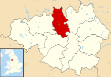 Bury shown in Greater Manchester and England | |
| Sovereign state | United Kingdom |
| Constituent country | England |
| Region | North West England |
| Ceremonial county | Greater Manchester |
| Admin. HQ | Bury |
| Government | |
| • Type | Bury Metropolitan Borough Council |
| • Leadership: | Leader & Cabinet |
| • Executive: | Labour |
| • MPs: | James Daly (C) Christian Wakeford (L) |
| Area | |
| • Total | 38.40 sq mi (99.46 km2) |
| • Rank | 215th |
| Population (mid-2019 est.) | |
| • Total | 190,990 |
| • Rank | Ranked 99th |
| • Density | 5,000/sq mi (1,900/km2) |
| Time zone | UTC+0 (Greenwich Mean Time) |
| • Summer (DST) | UTC+1 (British Summer Time) |
| Postcode | |
| Area code | 0161 |
| ONS code | 00BM (ONS) E08000002 (GSS) |
| Ethnicity | 92.1% White 5.4%% S. Asian or mixed 1.6% Black or mixed 0.8% Chinese or other[1] |
| Website | bury.gov.uk |
The Metropolitan Borough of Bury, which covers 24,511 acres (99 km2) and has a population of 181,900, was created on 1 April 1974, with the transfer of functions from the county borough of Bury and the boroughs of Prestwich and Radcliffe, along with the urban districts of Tottington and Whitefield, and part of the urban district of Ramsbottom, all previously in Lancashire.
History
In 2006, facing a budget shortfall of over £10 million, Bury Metropolitan Council decided to sell its painting by L. S. Lowry called "A Riverbank". The work, which depicts the River Irwell and cost £175 in 1951, was expected to fetch between £500,000 and £800,000.[3] Between the announcement and the sale at Christie's, the council was accused of "selling off the family silver". The authority, which had the painting on display at Bury Art Museum, said it was putting its people before a picture.[3] The painting raised £1.25 million for the authority on 17 November 2006 at the auction in London, costing the bidder £1,408,000 including commission.[3] Consequently, the council's membership of the Museums Association was cancelled and it was deregistered by the Museums, Libraries and Archives Council,[4][5] a quango that was disbanded in 2011, transferring some of its duties to Arts Council England.[6]
Local wards
In 2004 the Electoral Commission reviewed the electoral arrangements for Bury,[7] resulting in 17 wards:
These 17 wards are each represented by 3 councillors to form a council of 51 members. The Bury electorate figures based on the 2006 forecast are: Total electorate 140,697; Average electorate for ward 8,276; Average number of electors for councillor 2,759.
At the 2008 Bury Metropolitan Borough Council election the average turnout to vote was 38.22%. This varied locally with 47.32% of electors voting in North Manor ward and a low turnout of only 32.4% in Besses ward.[8]
In July 2008 the borough was the first in Greater Manchester to hold a referendum on whether to install a directly-elected mayor.[9] This was the result of a campaign against congestion charge plans that raised a petition with 9,460 names, well above the required five per cent of voters needed to trigger a mayoral vote.[10] The proposal to have an elected Mayor was rejected.[11]
Parliamentary constituencies
The Metropolitan Borough of Bury currently consists of two parliamentary constituencies:
- Bury North – James Daly (Conservative)
- Bury South – Christian Wakeford (Labour)
Unparished areas
Showing former status (prior to 1974)
The entirety of the borough is unparished.
- Bury (County Borough)
- Prestwich (Municipal Borough)
- Radcliffe (Municipal Borough)
- Ramsbottom (Urban District) (part)
- Tottington (Urban District)
- Whitefield (Urban District)
Coat of arms
The coat of arms contains symbols representing the six constituent towns, with the design based on the arms of the old County Borough of Bury. The shield is divided diagonally by interweaving alluding to the textile industry. On the shield are a bee (representing industry) and papyrus (papermaking) from Bury; a ram's head and a bullock's head represent Ramsbottom and Tottington respectively. The silver field represents Whitefield, whilst the shield is supported with figures from the crests of Radcliffe and Prestwich. These represent the Radcliffe and Egerton families and wear a red rose (for Lancashire) and a cogwheel (for industry). The motto 'Forward in Unity' sits on a scroll under the shield.
Demography
| Bury Compared | |||
|---|---|---|---|
| 2001 UK Census[12] | Bury | Greater Manchester | England |
| Total population | 180,608 | 2,514,757 | 49,138,831 |
| White | 93.9% | 91.2% | 90.9% |
| Asian | 4.0% | 5.6% | 4.6% |
| Black | 0.5% | 1.2% | 2.3% |
At the 2001 UK census, the Metropolitan Borough of Bury had a total population of 180,608.[12] For every 100 females, there were 95 males. The population density is 1,815/km2 (4,700/sq mi).[13]
When the Census was taken there were 74,335 households in Bury with an average of 2.4 persons in each one. In more detail, 39.4% of households were married couples living together, 28.9% were one-person households, 8.7% were co-habiting couples and 10.7% were lone parents.[14] Of all the households 75.11% lived in houses they owned, with or without a mortgage, significantly higher than the national average of 68.07%.[15]
Of people aged 16–74 in Bury 42.93% were economically active in 2001, higher than the national average of 40.81%.[16] 29.2% of this age group (16–74) had no academic qualifications, slightly higher than 28.9% in all of England.[17]
5.8% of Bury's residents were born outside the United Kingdom, significantly lower than the national average of 9.2%.[18] The largest minority group was recorded as Asian, at 4% of the population.[19]
Population and employment change
The table below details the population change since 1801, including the percentage change since the last available census data. Although the Metropolitan Borough of Bury has only existed since 1974, figures have been generated by combining data from the towns, villages, and civil parishes that would later be constituent parts of the borough.
| Population growth in Bury since 1801 | ||||||||||||||||||||||
|---|---|---|---|---|---|---|---|---|---|---|---|---|---|---|---|---|---|---|---|---|---|---|
| Year | 1801 | 1811 | 1821 | 1831 | 1841 | 1851 | 1861 | 1871 | 1881 | 1891 | 1901 | 1911 | 1921 | 1931 | 1941 | 1951 | 1961 | 1971 | 1981 | 1991 | 2001 | 2011 |
| Population | 12,169 | 14,987 | 17,646 | 22,331 | 33,696 | 38,613 | 61,749 | 84,885 | 108,020 | 117,677 | 123,882 | 130,415 | 132,599 | 134,825 | 138,276 | 141,817 | 157,142 | 174,165 | 175,459 | 179,168 | 180,612 | 185,060 |
| % change | – | +23.2 | +17.7 | +26.5 | +50.9 | +14.6 | +59.9 | +37.5 | +27.3 | +8.9 | +5.3 | +5.3 | +1.7 | +1.7 | +2.6 | +2.6 | +10.8 | +10.8 | +0.7 | +2.1 | +0.8 | +2.5 |
| Source: Vision of Britain[20] | ||||||||||||||||||||||
In 1971 34,980 people living in Bury were employed in manufacturing. By 2001 this had fallen to 13,690 – a decrease of 61%. During the same period the numbers of people employed in service industries increased from 34,200 to 54,227, a gain of 58.5%.[21]
Politics and services
Between 1974 and 1986, the Conservative Party controlled the council. In 1986, the Labour Party gained control and continued in power, at first with an overall Labour majority and subsequently through a Labour executive running the council in a state of no overall control, until 2007. The May elections in 2007 saw the Conservative Party become the largest group on the council and the Conservative Group took control of the council and its executive. The leader of the council was named as Councillor Bob Bibby. At the 2008 local elections, the Conservatives won three more seats and took overall control of the council. In 2010, the Conservatives lost overall control with the new council having 23 Conservative, 20 Labour and 8 Liberal Democrat councillors.[22]
The Audit Commission[23] reported in 2006 that Bury Council continues to make good and sustained progress in improving services for local people. Overall the council was awarded 'three star' status, similar to 47% of all local authorities.
The council was said to be improving well in children's services, particularly in social care. The Audit Commission also noted that resident satisfaction was rising, reflecting improvements in the quality of the environment and services generally. Ten parks have achieved green flag status, recycling levels are above average and street cleanliness is improving. The council is on target to reach its Decent Homes target by 2010.
The assessment concluded that the council has improved the way it uses its resources to deliver its plans, improving how it manages its finances and service performance and strengthening arrangements to make sure that it achieves good value for money.
Education
There are 60 primary schools, 13 secondary schools, 3 special schools and 2 Pupil Referral Units in the Borough.[24] Overall, Bury was ranked 23rd of the all local education authorities in SATs performance and 3rd in Greater Manchester in 2006.[25] In 2007, Bury LEA was ranked 45th out of 148 in the country – and 3rd in Greater Manchester – based on the percentage of pupils attaining at least 5 A*-C grades at GCSE including maths and English (47.8% compared with the national average of 45.8%).[26] The schools of the area compete annually in the Bury Schools Athletics Championships.
The borough has two colleges of further education. Bury College, which was originally Bury Technical College. In 1974, it merged with Radcliffe Technical College to form the Bury Metropolitan College of Further Education and, in 1987, it was renamed Bury College following its merger with Peel Sixth Form College, Stand Sixth Form College and a number of Youth Training Schemes. Holy Cross College was formerly Bury Convent Grammar School. It was a direct grant Catholic girls' school founded in 1878 by the Daughters of the Cross, a congregation of religious from Liège. In 2007 it was named 7th in the country.[clarification needed]
Bury is also home to one of the UK's oldest Islamic seminaries, Darul Uloom Bury, which was established in 1979 and located in Holcombe.
Landmarks

As of February 2004, Bury has 5 Grade I, 8 Grade II*, and 228 Grade II listed buildings.[27]
Bury is at the heart of the largest public art scheme in the UK – the Irwell Sculpture Trail. Works in the borough include Ulrich Ruckriem's sculpture in Radcliffe, on the site of the former Outwood Colliery. Ruckreim[28] is one of Germany's most eminent artists, best known for his monumental stone sculptures. His work at Outwood is one of his largest stone settings to date. Edward Allington's Tilted Vase sits in Market Place in the centre of Ramsbottom and has become a distinctive feature of interest.
Local Nature Reserves
There are six local nature reserves (LNRs) in the borough:[29]
- Chapelfield LNR, a Grade B Site of Biological Importance (SBI) with notable Water Violet Hottonia palustris.[30]
- Chesham Woods LNR, a group of six woodlands and grazing meadows, established as the borough's second LNR in 2000[31]
- Hollins Vale LNR, encompassing two Sites of Biological Importance: an area of grasslands which with historic hedgerows which Hollins Brook runs through; and woodland plantation.[32][33]
- Kirklees Valley LNR, through which the Kirklees Trail passes.[34]
- Philips Park LNR within the long-established Philips Park, the first and largest LNR in the borough, created in 1999, with a range of habitats, a countryside centre and a mountain bike trail .[35]
- Redisher LNR, also called Redisher Wood LNR,[36] a woodland valley around Holcombe Brook[37][38]
Religion

At the 2001 UK census, 73.6% of people in Bury stated they were Christian, with 4.94% following the Jewish and 3.74% the Muslim faiths.[39] The Jewish community in Prestwich and Whitefield is the second largest in the country.[40]
Bury is covered by the Roman Catholic Diocese of Salford,[41] and the Anglican Diocese of Manchester.[42]
There are four Grade I listed churches in Bury. The Church of All Saints, at Stand in Whitefield, was built in 1826.[43] The Parish Church of St Mary, Radcliffe, is a 14th-century church with a 15th-century tower.[44] The Church of St Mary the Virgin, Prestwich, is a 15th-century church.[45][46] The current Church of St Mary the Virgin, Bury, was built in 1876 by J. S. Crowther.[45][47] Of the nine Grade II* listed buildings in Bury, two are churches: Christ Church, Walshaw and the Presbyterian Chapel in Ainsworth.[48]
There are around 6 Mosques in Bury including one of the oldest Islamic seminaries in the United Kingdom, Darul Uloom Bury, which was established in 1979 in Holcombe.
The original Jewish immigrant community in Manchester was based in the inner city. As in other cities the community gradually moved outward geographically and upward economically from its roots establishing itself in the more leafy suburbs of Crumpsall and Broughton Park as well as the town of Prestwich. Later, a second migration of young families in the mid-1960s sought pastures even further away from these traditional areas settling in Whitefield, Sunny Bank and Unsworth.[49] There are now about 10 synagogues in the Borough.[50]
Twin towns
The Metropolitan Borough of Bury has five twin towns, in China, France, Germany and the United States.[51][52][53] Two of these were originally twinned with a place within the Metropolitan Borough prior to its creation in 1974.
| Country | Place | County / District / Region / State | Originally twinned with | Date | |||
|---|---|---|---|---|---|---|---|
| China | Datong | Shanxi | Metropolitan Borough of Bury | 2003 | |||
| France | Tulle | Limousin | Municipal Borough of Prestwich | 1969 | |||
| France | Angoulême | Poitou-Charentes | County Borough of Bury | 1959 | |||
| Germany | Schorndorf | Baden-Württemberg | Metropolitan Borough of Bury | 1994 | |||
| United States | Woodbury | New Jersey | Metropolitan Borough of Bury | 2000 |
Freedom of the Borough
The following people and military units have received the Freedom of the Borough of Bury.
This list is incomplete; you can help by adding missing items. (August 2019) |
Individuals
- Danny Boyle: 11 May 2009.
- Zoe Robinson: 11 May 2009.
- Members of the Band Elbow (Guy Garvey, Craig Potter, Mark Potter, Peter Turner, and Richard Jupp): 11 May 2009.
- Kieran Trippier: 14 July 2018.[55]
- Henry Donn MBE: 4 April 2022.[56]
Military Units
- 207 (Manchester) Field Hospital Royal Army Medical Corps: 20 October 2017.[57]
See also
- Bury local elections
- List of people from Bury
References
Notes
- "Resident Population Estimates by Ethnic Group (Percentages)". Office for National Statistics. Archived from the original on 12 June 2011. Retrieved 24 March 2008.
- "Greater Manchester (United Kingdom): Boroughs - Population Statistics, Charts and Map". www.citypopulation.de. Retrieved 13 June 2022.
- "Council's Lowry sold for £1.25M". BBC Online. London. 17 November 2006. Retrieved 15 January 2008.
- "Bury excluded by MA and de-accredited". Museums Association. 13 November 2009. Retrieved 11 September 2020.
- MLA – Press Releases – MLA removes Bury Art Gallery and Museum from national accreditation scheme[permanent dead link]
- "Research from the MLA". Arts Council England. Retrieved 11 September 2020.
- The Borough of Bury (Electoral Changes) Order 2004
- Bury Election results 2008 Archived 18 June 2008 at the Wayback Machine
- Bury Metropolitan Borough Council
- Britton, Paul (1 February 2008). "Bury to vote on mayor". Manchester Evening News.
- "Bury elected mayor plan rejected". BBC News. 4 July 2008.
- "Bury Metropolitan Borough key statistics". Statistics.gov.uk. Retrieved 17 January 2008.
- "Bury Metropolitan Borough population density". Statistics.gov.uk. Archived from the original on 12 June 2011. Retrieved 17 January 2008.
- "Bury Metropolitan Borough household data". Statistics.gov.uk. Archived from the original on 12 June 2011. Retrieved 17 January 2008.
- "Bury Metropolitan Borough housing data". Statistics.gov.uk. Retrieved 17 January 2008.
- "Bury Metropolitan Borough economic activity data". Statistics.gov.uk. Retrieved 17 January 2008.
- "Bury Metropolitan Borough qualifications". Statistics.gov.uk. Archived from the original on 12 June 2011. Retrieved 17 January 2008.
- "Bury Metropolitan Borough country of birth data". Statistics.gov.uk. Archived from the original on 12 June 2011. Retrieved 17 January 2008.
- "Bury Metropolitan Borough ethnic group data". Statistics.gov.uk. Archived from the original on 12 June 2011. Retrieved 17 January 2008.
- "Bury District: total population". Vision of Britain. Retrieved on 20 December 2008.
- "A Vision of Britain through Time Standardised Industry data". visionofbritain.org.uk.
- "Election 2010 – Bury – Con lose to NOC". BBC News Online. 7 May 2010. Retrieved 25 July 2010.
- "Bury Metropolitan Borough Council comprehensive performance assessment (CPA) scorecard 2006". Audit Commission. 2006. Archived from the original on 9 July 2012. Retrieved 28 January 2008.
- "Find a School". bury.go.uk. Bury MBC. Retrieved 25 November 2016.
- "LEA SATs performance". BBC Online. London. 7 December 2006. Retrieved 18 December 2007.
- "How different LEAs performed". BBC Online. London. 17 January 2007. Retrieved 18 December 2007.
- Bury Metropolitan Borough Council (19 February 2004). "Bury's historic built environment". Bury.gov.uk. Archived from the original (DOC) on 27 March 2009. Retrieved 27 May 2008.
- "Ulrich Rückriem". namenderkunst.com.
- "Nature Reserves". Bury Council. Retrieved 12 February 2018.
- "Chapelfield Local Nature Reserve". Bury Council. Retrieved 12 February 2018.
- "Chesham Woods Local Nature Reserve". Bury Council. Retrieved 12 February 2018.
- "Hollins Vale Local Nature Reserve". Bury Council. Retrieved 12 February 2018.
- "A Walk in Hollins Vale Local Nature Reserve". Hollins Conservation Group. Retrieved 12 February 2018.
- "Kirklees Valley Local Nature Reserve". Bury Council. Retrieved 12 February 2018.
- "A Walk in Philips Park Local Nature Reserve". Friends of Prestwich Forest Park and Bury Council. Retrieved 12 February 2018.
- "Redisher Woods LNR". Natural England. Retrieved 12 February 2018.
- "Redisher Local Nature Reserve". Bury Council. Retrieved 12 February 2018.
- "A Walk in Redisher Local Nature Reserve". Friends of Redisher Wood LNR and Bury Council. Retrieved 12 February 2018.
- "Bury Metropolitan Borough religion data". Statistics.gov.uk. Retrieved 17 January 2008.
- Bury Metropolitan Borough Council. "Prestwich local area partnership". Bury.gov.uk. Retrieved 28 January 2008.
- "Parishes of the Diocese". Salforddiocese.org.uk. Archived from the original on 2 May 2007. Retrieved 7 May 2007.
- "About the Diocese of Manchester" (PDF). Manchester.anglican.org. Archived from the original (PDF) on 29 February 2008. Retrieved 24 January 2008.
- Historic England. "Church of All Saints (1356818)". National Heritage List for England. Retrieved 23 December 2007.
- Historic England. "Church of St Mary and St Bartholomew (1163125)". National Heritage List for England. Retrieved 23 December 2007.
- Bury Metropolitan Borough Council. "Church of St Mary". bury.gov.uk. Archived from the original on 26 October 2007. Retrieved 23 December 2007.
- Historic England. "Church of St Mary (1067252)". National Heritage List for England. Retrieved 23 December 2007.
- Historic England. "Parish Church of St Mary, Bury (1067236)". National Heritage List for England. Retrieved 13 January 2008.
- Bury Metropolitan Borough Council. "Church of St Mary". bury.gov.uk. Archived from the original on 26 October 2007. Retrieved 24 January 2008.
- "Bury Hebrew Congregation History". Archived from the original on 6 April 2008. Retrieved 24 January 2008.
- "Greater Manchester Synagogues". Archived from the original on 20 January 2008. Retrieved 24 January 2008.
- Bury Council : Twinning : China Retrieved 8 January 2010
- Bury Council : Twinning : France Retrieved 8 January 2010
- Bury Council : Twinning : United States of America Retrieved 8 January 2010
- "Freedom of the Borough for local heroes - Manchester Evening News".
- "Kieran Trippier: England defender to be awarded freedom of Bury following World Cup - BBC Sport".
- Oldman, Isabel (4 April 2022). "Art gallery owner and former magistrate awarded Freedom of the Borough". The Bury Times. Retrieved 6 April 2022.
- "Territorial army hospital given Freedom of the Borough". Bury Times.
Bibliography
- Clark, David M. (1973). "Greater Manchester Votes: A Guide to the New Metropolitan Authorities". Redrose.
{{cite journal}}: Cite journal requires|journal=(help)
External links
Districts of North West England | ||
|---|---|---|
| Cheshire |  | |
| Cumbria |
| |
| Greater Manchester | ||
| Lancashire | ||
| Merseyside | ||
Metropolitan districts of England | ||
|---|---|---|
| Districts |
|  |
| Councils |
| |
| Local elections |
| |
| Authority control |
|
|---|
На других языках
[de] Metropolitan Borough of Bury
Bury ist ein Metropolitan Borough im Metropolitan County Greater Manchester in England. Verwaltungssitz ist die gleichnamige Stadt Bury, in der rund ein Drittel der Bevölkerung lebt. Weitere bedeutende Orte im Borough sind Prestwich, Radcliffe, Ramsbottom, Tottington und Whitefield. Partnerstädte sind Datong (China), Angoulême und Tulle (Frankreich), Schorndorf (Deutschland) sowie Woodbury (Vereinigte Staaten).- [en] Metropolitan Borough of Bury
[es] Municipio metropolitano de Bury
El Municipio Metropolitano de Bury es un municipio metropolitano del Gran Mánchester, al noroeste de Inglaterra. Bordea el norte de la ciudad de Mánchester. Se compone de seis ciudades: Bury, Ramsbottom, Tottington, Radcliffe, Whitefield y Prestwich. Al norte limita con los distritos de Lancashire: Rossendale y Blackburn with Darwen.[ru] Бери (район)
Бери (англ. Bury) — метрополитенский район (боро) в церемониальном графстве Большой Манчестер в Англии. Административный центр — город Бери.Другой контент может иметь иную лицензию. Перед использованием материалов сайта WikiSort.org внимательно изучите правила лицензирования конкретных элементов наполнения сайта.
WikiSort.org - проект по пересортировке и дополнению контента Википедии