world.wikisort.org - United_Kingdom
The Metropolitan Borough of St Helens is a local government district with borough status in Merseyside, North West England. The borough is named after its largest settlement, St Helens but also includes neighbouring towns and villages such as Earlestown, Rainhill, Eccleston, Clock Face, Haydock, Billinge, Rainford and Newton-le-Willows.
Borough of St Helens | |
|---|---|
Metropolitan borough | |
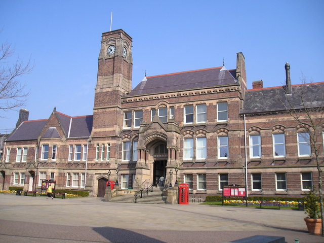 St Helens Town Hall, the seat of the Borough Council | |
 Coat of Arms of the Borough Council | |
| Motto: Ex Terra Lucem ( formerly 'Prosperitas in Excelsis') | |
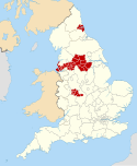
 St Helens shown within Merseyside and England | |
| Sovereign state | United Kingdom |
| Constituent country | England |
| Region | North West England |
| Ceremonial county | Merseyside |
| Historic county | Lancashire |
| Admin HQ | St Helens (Town Hall) |
| Founded | 1 April 1974 |
| Government | |
| • Type | Metropolitan borough |
| • Governing body | St Helens Metropolitan Borough Council |
| • Leadership: | Leader & Cabinet |
| • Executive: | Labour |
| • Leader of the Council | Cllr David Baines (Lab) |
| • MPs: | Conor McGinn (Lab), Marie Rimmer CBE (Lab) |
| Population (mid-2019 est.) | |
| • Total | 180,585 (Ranked 104th) |
| • Ethnicity | 98.8% White |
| Demonym | Saint Helenian |
| Time zone | UTC+0 (Greenwich Mean Time) |
| Postcodes | |
| Area code | 01744 / 01942 / 01925 / 0151 |
| Website | http://www.sthelens.gov.uk/ |
The Metropolitan Borough Council is made up of 48 councillors, three representing each of the 16 wards.[1]
History
The Metropolitan Borough was formed on 1 April 1974 as a merger of the former County Borough of St Helens, along with the urban districts of Haydock, Newton-le-Willows and Rainford, and parts of Billinge-and-Winstanley and Ashton-in-Makerfield urban districts, along with part of Whiston Rural District, all from the administrative county of Lancashire.
Between 1974 and 1986 (when it was abolished), the borough council shared functions with Merseyside County Council. After abolition, the functions of this body were in part devolved to the boroughs and in part transferred to ad hoc agencies.
Governance
St Helens Metropolitan Borough Council Composition
Elections to St Helens Metropolitan Borough Council are held in three out of every four years, with one-third of the 48 seats on the council being elected at each election.
The Labour party has had a majority on the council since the first election in 1973, except for a period between the 2004 election and the 2010 election when no party had a majority. This allowed an alliance between the Liberal Democrats and the Conservatives to take control after the 2006 election until Labour regained control in 2010.
Since then Labour has strengthened its position on the council and as of the 2021 election the council is composed of the following councillors:-[2]
| Party | Councillors | |
| Labour Party | 34 | |
| Liberal Democrats | 4 | |
| Conservative Party | 3 | |
| Independents | 4 | |
| Green Party | 3 | |
Parliamentary constituencies
- St Helens North
- St Helens South and Whiston
Liverpool City Region Combined Authority
The Metropolitan Borough of St Helens is one of the six constituent local government districts of the Liverpool City Region. Since 1 April 2014, some of the borough's responsibilities have been pooled with neighbouring authorities and subsumed into the Liverpool City Region Combined Authority.
The combined authority has effectively become the top-tier administrative body for the local governance of the city region and the leader of St Helens Metropolitan Borough Council, along with the five other leaders from neighbouring local government districts, take strategic decisions over economic development, transport, employment and skills, tourism, culture, housing and physical infrastructure.
Geography

The borough borders the borough of Knowsley, in the south-west, the district of West Lancashire in the north, the Borough of Wigan in the north-east, and to the south the boroughs of Warrington and Halton.
The St Helens Borough covers roughly 30 km² over an area of soft rolling hills used primarily for agricultural purposes, mainly arable. The highest point in the Metropolitan Borough of St Helens, and the whole of Merseyside, is Billinge Hill, 4.5 miles (7.2 km) north from St. Helens centre. The borough is landlocked with a stream running through, Mill Brook/Windle Brook running through Eccleston and connecting with the (disused) St. Helens Branch/Section of the Sankey Canal in the town centre. The centre of St Helens is around 160 feet (50 m) above sea level.
From the top of Billinge Hill the cities of Manchester and Liverpool are visible on a clear day as well as the towns of Bolton and Warrington.
Carr Mill Dam is Merseyside's largest body of inland water, offering picturesque lakeside trails and walks as well as national competitive powerboating and angling events.
The Burgies are two tailings on the site of the old Rushy Park coal mine. They were created by the dumping of toxic chemical waste from the manufacture of glass, they have since been covered with tall grass and woodland.
Demography
| St Helens Population using 2011 Data, 2008 Wards | |||
|---|---|---|---|
| 2001 UK Census | Population | Households | |
| Billinge and Seneley Green | 12,717 | 4985 | |
| Blackbrook | 9,128 | 3,604 | |
| Bold | 9,040 | 3,586 | |
| Earlestown | 10,274 | 4,420 | |
| Eccleston | 10,528 | 4,218 | |
| Haydock | 11,962 | 4,817 | |
| Moss Bank | 10,276 | 4,337 | |
| Newton | 22,144 | 4,506 | |
| Parr | 18,082 | 3,541 | |
| Rainford | 2,344 | 3,484 | |
| Rainhill | 11,913 | 4,762 | |
| Sutton | 12,622 | 5,075 | |
| Thatto Heath | 9,393 | 3,852 | |
| Town Centre | 13,795 | 4,958 | |
| West Park | 4,558 | 4,947 | |
| Windle | 6,621 | 3,607 | |
| Total | 176,843 | 72,697 | |
Ethnicity
| Ethnic Group | 2001[3] | 2011[4] | ||
|---|---|---|---|---|
| Number | % | Number | % | |
| White: British | 172,853 | 97.74% | 169,346 | 96.59% |
| White: Irish | 1,054 | 0.60% | 887 | 0.50% |
| White: Gypsy or Irish Traveller | 69 | 0.04% | ||
| White: Other | 880 | 0.50% | 1,575 | 0.90% |
| White: Total | 174,787 | 98.84% | 171,887 | 98.05% |
| Asian or Asian British: Indian | 409 | 0.23% | 504 | 0.29% |
| Asian or Asian British: Pakistani | 109 | 0.06% | 133 | 0.08% |
| Asian or Asian British: Bangladeshi | 79 | 0.04% | 122 | 0.07% |
| Asian or Asian British: Chinese | 398 | 0.23% | 512 | 0.29% |
| Asian or Asian British: Other Asian | 85 | 0.05% | 493 | 0.28% |
| Asian or Asian British: Total | 1,080 | 0.61% | 1,764 | 1.01% |
| Black or Black British: African | 73 | 0.04% | 152 | 0.09% |
| Black or Black British: Caribbean | 59 | 0.03% | 60 | 0.03% |
| Black or Black British: Other Black | 37 | 0.02% | 36 | 0.02% |
| Black or Black British: Total | 169 | 0.10% | 248 | 0.14% |
| Mixed: White and Black Caribbean | 228 | 0.13% | 445 | 0.25% |
| Mixed: White and Black African | 77 | 0.04% | 167 | 0.10% |
| Mixed: White and Asian | 200 | 0.11% | 271 | 0.15% |
| Mixed: Other Mixed | 169 | 0.10% | 296 | 0.17% |
| Mixed: Total | 674 | 0.38% | 1,179 | 0.67% |
| Other: Arab | 117 | 0.07% | ||
| Other: Any other ethnic group | 123 | 0.07% | ||
| Other: Total | 133 | 0.08% | 240 | 0.14% |
| Black, Asian, and minority ethnic: Total | 2,056 | 1.16% | 3,431 | 1.96% |
| Total | 176,843 | 100.00% | 175,308 | 100.00% |
Education
Coat of arms
| Coat of Arms of St Helens Council | |
|---|---|
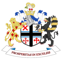 | |
| Armiger | College of Heralds |
| Adopted | 1974 |
| Crest | A rams head with fleur-de-lys mounted on a helmet, representing Lord Newton |
| Blazon | Quarterly: 1 red saltire representing Ashton and Seneley Green, 2 Black griffin representing Rainhill, 3 Pilkingtons Cross representing Windle], 4 Red crosslet representing Billinge summounted by the Black Cross of Haydock & Eccleston and the Blue Bars of Parr. |
| Supporters | A golden lion and a black griffin |
| Motto | Latin: Ex Terr Lucem English: From the Earth Light, (formerly Prosperitas in Excelsis English: "Flourishing Well") [5] |
| Use | On all council documents |
Twin Town
St Helens is twinned with:[6]
 Stuttgart, Germany
Freedom of the Borough
The following people, military units and Organisations and Groups have received the Freedom of the Borough of St Helens.
This list is incomplete; you can help by adding missing items. (May 2022) |
Individuals
- Rt Hon Lord Pilkington of St Helens Kt: 1968.
- Rt Hon Lord Evans of Parkside: 1997.[7]
- Rt Hon Lord Watts of Ravenhead: 13 May 2022.[8]
Military Units
- The Royal Military Police Association (Merseyside Branch): 29 February 2012.[9]
Organisations and Groups
- The St Helens and Knowsley Teaching Hospitals NHS Trust: 13 May 2022.[10]
References
- "Find your councillor". St Helens Council. Retrieved 10 January 2013.
- Hughes, Lorna (24 May 2014). "Labour increases majority as UKIP fails to make major inroads - St Helens". Liverpool Echo. NewsBank.
- "UV009 - Ethnic group". NOMIS. Retrieved 2 September 2022.
- "KS201EW - Ethnic group". NOMIS. Retrieved 2 September 2022.
- "Town reverts back to old motto". Archived from the original on 5 March 2014.
- St Helen's Council, Stuttgart visits St Helens retrieved 21 January 2019
- "Nominating Freemen for the Millennium". The Lancashire Telegraph. Retrieved 13 May 2022.
- Cunningham, Conal (13 May 2022). "David Watts and NHS staff granted 'Freedom of the Borough' in St Helens". The St Helens Star. Retrieved 13 May 2022.
- "Civic Honours Granted to The Adjutant-General's Corps (Royal Military Police), Its Units/sub-Units, Association and Antecedent Corps" (PDF). The Royal Military Police. Retrieved 13 May 2022.
- "Hospital Trust and former St Helens MP presented with Freedom of the Borough scrolls". St Helens Borough Council. Retrieved 13 May 2022.
External links
- St. Helens Metropolitan Borough Council
- Earlestown Historical Website
- Newton-le-Willows Historical Website
Districts of North West England | ||
|---|---|---|
| Cheshire |  | |
| Cumbria |
| |
| Greater Manchester | ||
| Lancashire | ||
| Merseyside | ||
Metropolitan districts of England | ||
|---|---|---|
| Districts |
|  |
| Councils |
| |
| Local elections |
| |
Authority control | |
|---|---|
| National libraries | |
| Other |
|
На других языках
[de] Metropolitan Borough of St Helens
St Helens ist ein Metropolitan Borough im Metropolitan County Merseyside in England. Verwaltungssitz ist die gleichnamige Stadt St Helens, in der etwas mehr als die Hälfte der Bevölkerung lebt. Weitere bedeutende Orte im Borough sind Earlestown, Eccleston, Haydock, Newton-le-Willows und Rainford.- [en] Metropolitan Borough of St Helens
[ru] Сент-Хеленс (район)
Сент-Хеленс (англ. St Helens) — метрополитенский район (боро) в церемониальном графстве Мерсисайд в Англии. Административный центр — город Сент-Хеленс.Другой контент может иметь иную лицензию. Перед использованием материалов сайта WikiSort.org внимательно изучите правила лицензирования конкретных элементов наполнения сайта.
WikiSort.org - проект по пересортировке и дополнению контента Википедии