world.wikisort.org - United_Kingdom
Swale is a local government district with borough status in Kent, England and is bounded by Medway to the west, Canterbury to the east, Ashford to the south and Maidstone to the south west. Its council is based in Sittingbourne. The district is named after the narrow channel called The Swale, that separates the mainland of Kent from the Isle of Sheppey, and which occupies the central part of the district.
This article has multiple issues. Please help improve it or discuss these issues on the talk page. (Learn how and when to remove these template messages)
|
Borough of Swale | |
|---|---|
Non-metropolitan district | |
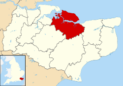 Swale shown within Kent | |
| Sovereign state | United Kingdom |
| Constituent country | England |
| Region | South East England |
| Non-metropolitan county | Kent |
| Status | Non-metropolitan district |
| Admin HQ | Sittingbourne |
| Incorporated | 1 April 1974 |
| Government | |
| • Type | Non-metropolitan district council |
| • Body | Swale Borough Council |
| • Leadership | Leader & Cabinet (Conservative) |
| • MPs | Helen Whately (C) Gordon Henderson (C) |
| Area | |
| • Total | 144.2 sq mi (373.4 km2) |
| • Rank | 106th (of 309) |
| Population (mid-2019 est.) | |
| • Total | 150,082 |
| • Rank | 137th (of 309) |
| • Density | 1,000/sq mi (400/km2) |
| • Ethnicity[1] | 96.1% White 1.3% S.Asian 1.1% Black 1.0% Mixed Race |
| Time zone | UTC0 (GMT) |
| • Summer (DST) | UTC+1 (BST) |
| ONS code | 29UM (ONS) E07000113 (GSS) |
| OS grid reference | TQ9018863720 |
| Website | www |
The district was formed in 1974 under the Local Government Act 1972, from the Borough of Faversham; the Borough of Queenborough-in-Sheppey, which covered the whole of Sheppey; the Sittingbourne and Milton Urban District; and Swale Rural District.
Most of the southern half of the Borough lies within the Kent Downs Area of Outstanding Natural Beauty, whilst Sittingbourne and the Isle of Sheppey forms the concluding part of the Thames Gateway growth area.[2]
There are four towns in the borough: Sittingbourne and Faversham on the mainland, and Sheerness and Queenborough on Sheppey.
Economy
Swale is a mainly rural borough, containing a high proportion of the UK's apple, pear, cherry and plum orchards (the North Kent Fruit Belt[3]), as well as many of its remaining hop gardens. Faversham has the Shepherd Neame brewery.
Sheerness is a busy port and previously produced steel. Sittingbourne has a variety of smaller industrial sites.
Transport
The Roman Watling Street passed through the area, as witness the straightness of the A2 main road, now by-passed by the M2 motorway.
There are two railway lines in Swale: the Chatham Main Line and the Sheerness Line, which meet at Sittingbourne.
Governance
Swale Borough Council | |
|---|---|
 | |
| Type | |
| Type | Borough Council |
| History | |
| Founded | 1 April 1974 |
| Leadership | |
Mayor | Cllr Simon Clark, Labour |
Leader of the Council | Cllr Mike Baldock, Swale Independents Alliance |
Deputy Leader of the Council | Cllr Monique Bonney, Independent |
Leader of the Opposition | Cllr Alan Horton, Conservative |
Chief Executive | Larissa Reed |
| Structure | |
| Seats | 47 councillors |
 | |
Political groups |
|
Length of term | 4 years |
| Elections | |
Voting system | First-past-the-post |
Last election | 2019 |
Next election | 2023 |
| Motto | |
| Known By Their Fruits | |
| Meeting place | |
| Swale House, Sittingbourne | |
| Website | |
| www | |
Chairmen
- 1973-74 R. D. Sharrock
- 1974-75 R. D. Sharrock
- 1975-76 K. H. Burbidge
- 1976-77 R. W. Barnicott
Mayors
- 1977-78 R. W. Barnicott
- 1978-79 J. M. Elliott
- 1979-80 J. M. Elliott
- 1980-81 A. M. North
- 1981-82 T. T. Holden
- 1982-83 L. A. Nash
- 1983-84 H. T. Curling
- 1984-85 William Boggia
- 1985-86 Richard Moreton
- 1986-87 Kenneth Ingleton
- 1987-88 Peter Morgan
- 1988-89 L. T. Vaughan
- 1989-90 Mrs Jean Newman
- 1990-91 Mrs Jean Newman
- 1991-92 Keith Evans
- 1992-93 Brian Groves
- 1993-94 Brian Austen
- 1994-95 L. T. Vaughan
- 1995-96 Don Jordan
- 1996-97 Ernest Madgwick
- 1997-98 David Sargent
- 1998-99 Gerry Lewin
- 1999-00 Mrs Ann McLean
- 2000-01 Peter Salmon
- 2001-02 Mrs Brenda Simpson
- 2002-03 Mrs Brenda Hammond
- 2003-04 Mick Constable
- 2004-05 Colin Prescott
- 2005-06 Bryan Mulhern
- 2006-07 John Morris
- 2007-08 John Morris
- 2008-09 Alan Willicombe
- 2009-10 Adrian Crowther
- 2010-11 Steve Worrall
- 2011-12 Ben Stokes
- 2012-13 Mrs Pat Sandle
- 2013-14 Mrs Sue Gent
- 2014-15 George Bobbin
- 2015-16 Mrs Anita Walker
- 2016-17 Mrs Lesley Ingham
- 2017-18 Colin Prescott
- 2018-19 Samuel Koffie-Williams
- 2019-20 Kenneth Ingleton
- 2020-21 Paul Stephen
- 2021-22 Paul Stephen
- 2022-23 Simon Clark
Honorary Freemen of the Borough
- 1978 D. Allen
- 1982 Mrs D. M. Elvy JP DL
- 1986 Bob Geldof KBE [4]
- 2004 Gerald David Thomsett
- 2004 Peter James Salmon
- 2018 Stephen Mark Brown
- 2021 Peter Morgan MBE
- 2021 Robin Castle MBE [5][6]
Elections
Swale Borough Council is elected every four years, with currently 47 councillors being elected at each election. After the Conservatives had a majority on the council from 1976 to 1986, no party had overall control from 1986 until the 2002 election when the Conservatives regained control. The Conservatives held their majority until the last election in 2019 when the council returned to no overall control. The council is currently composed of the following councillors:-[7]
| Party | Councillors | |
| Conservative Party | 15 | |
| Labour Party | 9 | |
| Independent | 8 | |
| Swale Independents | 8 | |
| Liberal Democrats | 4 | |
| Green | 2 | |
| Reform UK | 1 | |
Parishes
The district contains the following civil parishes:
- Bapchild
- Bobbing
- Borden
- Boughton-under-Blean
- Bredgar
- Conyer
- Danaway
- Doddington
- Dunkirk
- Eastchurch
- Eastling
- Faversham
- Goodnestone
- Graveney
- Hartlip
- Hernhill
- Iwade
- Leysdown
- Lower Halstow
- Lynsted
- Kemsley
- Milstead
- Milton Regis
- Minster-on-Sea
- Murston
- Newington
- Newnham
- Norton, Buckland and Stone
- Oare
- Ospringe
- Rodmersham
- Rushenden
- Selling
- Sheldwich, Badlesmere and Leaveland
- Stalisfield
- Teynham
- Throwley
- Tonge
- Tunstall
- Upchurch
- Warden
References
- Office for National Statistics: Neighbourhood Statistics: Swale
- "Swale". Protecting Kent's Countryside. CPRE Kent. Retrieved 14 August 2015.
- Orchards http://www.englandinparticular.info/orchards/o-kent.html
- "Photograph of Bob Geldof Receiving the Freedom of the Borough of Swale". Shutterstock. Retrieved 31 October 2021.
- Dunt, Paul (13 October 2021). "Former Sheerness RNLI Coxswain honoured with Freedom of the Borough". The Royal National Lifeboat Institution. Retrieved 31 October 2021.
- "Photograph of Robin Swale Receiving the Freedom of the Borough of Swale". Twitter. Retrieved 31 October 2021.
- "Swale Borough Council". BBC News. Retrieved 3 February 2020.
External links
Districts of South East England | ||
|---|---|---|
| Berkshire |  | |
| Buckinghamshire |
| |
| East Sussex | ||
| Hampshire |
| |
| Isle of Wight | ||
| Kent | ||
| Oxfordshire | ||
| Surrey | ||
| West Sussex | ||
| Authority control |
|
|---|
На других языках
[de] Borough of Swale
Swale ist ein Verwaltungsbezirk mit dem Status eines Borough in der Grafschaft Kent in England. Er ist nach dem schmalen Swale-Kanal benannt, der die Isle of Sheppey vom übrigen Kent trennt. Der größte Teil des Bezirks liegt auf der Insel. Verwaltungssitz ist Sittingbourne; weitere bedeutende Orte sind Bobbing, Eastchurch, Faversham, Queenborough und Sheerness.- [en] Borough of Swale
[ru] Суэйл
Суэ́йл (англ. Swale /sweɪl/) — неметрополитенский район (англ. non-metropolitan district) со статусом боро в графстве Кент (Англия). Административный центр — город Ситтингберн.Другой контент может иметь иную лицензию. Перед использованием материалов сайта WikiSort.org внимательно изучите правила лицензирования конкретных элементов наполнения сайта.
WikiSort.org - проект по пересортировке и дополнению контента Википедии