world.wikisort.org - United_Kingdom
The Vale of White Horse is a local government district of Oxfordshire in England. It was historically a north-west projection of Berkshire. The area is commonly referred to as the 'Vale of the White Horse'. It is crossed by the Ridgeway National Trail in its far south, across the North Wessex Downs AONB at the junction of four counties. The northern boundary is defined by the River Thames. The name refers to Uffington White Horse, a prehistoric hill figure.
Vale of White Horse
Vale of White Horse District | |
|---|---|
Non-metropolitan district | |
 Characteristic landscape of farmland, hills and woodlands | |
 Vale of White Horse shown within Oxfordshire | |
| Sovereign state | United Kingdom |
| Constituent country | England |
| Region | South East England |
| Non-metropolitan county | Oxfordshire |
| Historic county | Berkshire |
| Status | Non-metropolitan district |
| Admin HQ | Milton, Vale of White Horse |
| Incorporated | 1 April 1974 |
| Government | |
| • Type | Non-metropolitan district council |
| • Body | Vale of White Horse District Council |
| • Executive | Liberal Democrat |
| • MPs | Layla Moran (Liberal Democrat) David Johnston (Conservative) |
| Area | |
| • Total | 223.4 sq mi (578.6 km2) |
| • Rank | 76th (of 309) |
| Population (mid-2019 est.) | |
| • Total | 136,007 |
| • Rank | 165th (of 309) |
| • Density | 610/sq mi (240/km2) |
| • Ethnicity[1] | 95.6% White 1.4% S.Asian 1.2% Chinese or other 1.1% Mixed Race 0.7% Black British |
| Time zone | UTC0 (GMT) |
| • Summer (DST) | UTC+1 (BST) |
| ONS code | 38UE (ONS) E07000180 (GSS) |
| OS grid reference | SU3462689188 |
| Website | www |
History
The area has been long settled as a productive fertile chalklands above well-drained clay valleys and well-farmed with many small woodlands and hills between the Berkshire Downs and the River Thames on its north and east sides. It is named after the prominent and large Bronze Age-founded Uffington White Horse hill figure.
The name "Vale of the White Horse" predates the present-day local authority district, having been described, for example, in the 1870-72 Imperial Gazetteer of England and Wales.[2]
The district had essentially been the majority of Wantage Rural District and three small towns in the county of Berkshire from their late 19th century inception as districts until local government re-organisation in 1974 when its parishes of Ardington, Blewbury, Childrey, Chilton, Denchworth, East Challow, East Hanney, East Hendred, Goosey, Grove, Harwell, Letcombe Bassett, Letcombe Regis, Lockinge, Sparsholt, Upton, West Challow, West Hanney and West Hendred became the new district in Oxfordshire. The rest became part of Newbury (later West Berkshire)'s district of the rump county. The towns (and predecessor urban districts) are, in size order, Abingdon, Faringdon and Wantage. There are 68 parishes in the district.
The local government district was formed on 1 April 1974 from: the Municipal Borough of Abingdon, Wantage Urban District, Abingdon Rural District, Faringdon Rural District and part of the Wantage Rural District of Berkshire.
Politics
The Vale of White Horse District Council is based in Milton Park, Milton. The council has been controlled by either Liberal Democrat or Conservative administrations since Vale of White Horse was created in 1973. The council was run by the Conservative Party from 2011 until the 2019 UK local elections, at which the Liberal Democrats regained control in a landslide, after having previously held the council from 1995 to 2011.[3]
Geography
The Vale is the valley of the Ock, a stream which joins the Thames from the west at Abingdon. It is almost flat and well wooded, its green meadows and foliage contrasting richly with the bald summits of the Berkshire Downs, which flank it on the south. The numerous elm trees that once were a major feature of the Vale were lost to Dutch Elm Disease. To the north, a low ridge separates it from the upper Thames Valley, holding back the soft Jurassic sedimentary deposits (Greensand, Gault and Kimmeridge Clay) behind a hard corallian limestone escarpment ridge, in what is technically a hanging valley; but local usage sometimes extends the vale to cover all the ground between the Cotswolds (on the north) and the Berkshire Downs. According to the geographical definition, however, the Vale is from two to five miles wide, and the distance by road from Abingdon to Shrivenham at its head is 18 miles.
Wantage is the only town in the foot or slopes of the vale (Faringdon, on the northwestern rim, is closely associated). Wantage is in a sheltered hollow at the foot of the hills, along which villages concentrate often in long strip parishes. Numerous springs, the run-off from the chalk hills were main local water sources, and an accessible water table enabled the growing of fruits, grains and vegetables.
Sites of interest
White Horse Hill
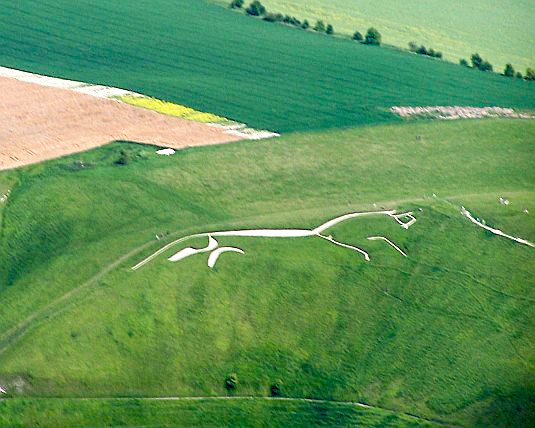
Towards the west, above Uffington, the hills reach a culminating point of 261 m (856 ft) in White Horse Hill. In its northern flank, just below the summit, a gigantic figure of a horse is cut, consisting of deep trenches filled with crushed white chalk. This figure gives name to the hill, the range and the Vale. It is 114 m (374 ft) long and highly stylised, the neck, body and tail varying little in width.

The origin of the figure is unknown. Tradition asserted it to be the monument of a victory over the Danes by King Alfred, who was born at Wantage, but the site of the Battle of Ashdown (871 CE), has been variously located. Moreover, the figure has been dated to the Bronze Age, so it pre-dates the battle by many centuries. Many ancient remains occur in the vicinity of the Horse.

On the summit of the hill there is an extensive and well-preserved circular camp, apparently used by the Romans but of much earlier origin. It is an Iron Age hill fort named Uffington Castle, after the village in the vale below. Within a short distance are Hardwell Castle, a near-square work and, on the southern slope of the hills near Ashdown House, a small camp traditionally called Alfred's Castle. Further to the West, there is Liddington Castle.
A smooth, steep gully on the north flank of White Horse Hill is called the Manger, and to the west of it rises a bald mound named Dragon Hill, the traditional scene of St George's victory over the dragon, the blood of which made the ground bare of grass for ever. But the name may derive from Celtic Pendragon ("dragon's head"), which was a title for a king, and may point to an early place of burial.
The Vale as a whole appears at the beginning of Tom Brown's Schooldays, as the scene of innocent Saxon boyhood adventures, before the eponymous hero is sent away to school at Rugby. Rosemary Sutcliff's 1977 historical novel Sun Horse, Moon Horse takes place in the Vale, telling the tale of the White Horse's creation in ancient Celtic times.
Waylands Smithy
To the west of White Horse Hill lies a long barrow called Wayland's Smithy, said to be the home of a smith who was never seen, but who shod the horses of travellers if they were left at the place with payment. The legend is elaborated, and the smith appears as a character, in Sir Walter Scott's novel Kenilworth, and in Rudyard Kipling's Puck of Pook's Hill.
The Ridgeway
A grassy track represents the Ridgeway, claimed as the oldest road in Europe, perhaps five thousand years old or more. It travels along the crest of the hills, far above what would then have been marshy lowlands or forests, continuing Icknield Street, from the Chilterns to Goring and Streatley on the River Thames. It links The Wash and Salisbury Plain, and would have been an important artery for trade.
Other earthworks, in addition to those near the White Horse, overlook the Vale, such as Letcombe Castle (also known as Segsbury Camp) above Wantage. At the foot of the hills, not far east of the Horse, is preserved the so-called Blowing Stone of Kingston Lisle, a mass of sandstone (a sarsen) pierced with holes in such a way that, when blown like a trumpet, it produces a loud note. It is believed that, in earlier times, the stone served the purpose of a bugle.
Several of the village churches in the Vale are of interest, notably the fine Early English cruciform building at Uffington, that has an octagonal tower and is known as The Cathedral of the Vale.[4]
Economy
This section needs additional citations for verification. (September 2011) |

Farming is mostly arable. In livestock the range is mixed. The area had a large dairy industry, especially in the 1960s, but it was much reduced by the 21st century, with the large fertile fields supported by subsidies. The Lockinge Estate is a longstanding agricultural employer within the region.
Natural mineral resources are mined (quarried) in the Vale. These include sand, gravel and (formerly) Fuller's Earth.
With the closure of British Leyland's long-established MG works at Abingdon in 1980,[5] there is no motor industry, apart from some specialist car makers and component factories. Macdermid Autotype in Wantage remains one of the few large industrial employers in the region.
The length of the Vale is traversed by the Great Western Main Line and the Cherwell Valley Line. Appleford railway station and Radley railway station are now the only stations within the Vale, although there used to be stations at Challow, Uffington, Grove (near Wantage), Abingdon and Steventon. These all closed as part of the Beeching cuts, in the early 1960s. The nearest mainline stations are now Swindon, Oxford and Didcot Parkway.
The Harwell Science and Innovation Campus is a large employer, particularly for scientists and engineers.
At one time Amey plc had its head office in Sutton Courtenay, Vale of White Horse.[6]
See also
- Vale and Downland Museum - local museum for the region.
- Vale of the Red Horse – another vale of a similar name that once carried some 1, 2, 3, 4 or 5 hill figures of a horse.
- Vale of White Horse Hunt - fox hunting pack named after the region.
Notes
- "Resident Population Estimates by Ethnic Group, Vale of White Horse". Office for National Statistics.
- "Vale of White Horse Oxfordshire". A vision of Britain though time. Retrieved 2 July 2021.
- "Election results: Lib Dems win Oxfordshire Tory council". BBC News. 3 May 2019. Retrieved 3 May 2019.
- Nash Ford, David. "Uffington: St. Mary's Church". Berkshire History. Retrieved 9 February 2016.
- Webb, Clifford (24 October 1980). "The MG factory at Abingdon closes today". Honest John. Retrieved 4 June 2018.
- "Amey bids for high-flying firm". Oxford Mail. 22 January 1999. Retrieved 9 February 2016.
References
- Thomas Hughes, The Scouring of the White Horse (1859).
- G. K. Chesterton, "The Ballad of the White Horse" (1911).
- Rudyard Kipling, "Puck of Pook's Hill".
- Tom Brown's Schooldays
The District of the Vale of White Horse | ||
|---|---|---|
| ||
| Towns |
|  |
| Large villages |
| |
| Other civil parishes (component villages and hamlets) |
| |
| Former districts and boroughs |
| |
| Former constituencies |
| |
| ||
Oxfordshire Portal | |
| Boroughs or districts | |
| Major settlements |
|
| Topics |
|
Districts of South East England | ||
|---|---|---|
| Berkshire |  | |
| Buckinghamshire |
| |
| East Sussex | ||
| Hampshire |
| |
| Isle of Wight | ||
| Kent | ||
| Oxfordshire | ||
| Surrey | ||
| West Sussex | ||
| Authority control |
|
|---|
На других языках
[de] Vale of White Horse
Vale of White Horse („Tal des weißen Pferdes“) ist ein District in der Grafschaft Oxfordshire in England und nach dem Scharrbild Uffington White Horse benannt. Verwaltungssitz ist Abingdon; weitere bedeutende Orte sind Grove, Faringdon und Wantage.- [en] Vale of White Horse
[ru] Вейл-оф-Уайт-Хорс
Вейл-оф-Уайт-Хорс (англ. Vale of White Horse) — неметрополитенский район (англ. non-metropolitan district) в графстве Оксфордшир (Англия). Административный центр — город Абингдон.Другой контент может иметь иную лицензию. Перед использованием материалов сайта WikiSort.org внимательно изучите правила лицензирования конкретных элементов наполнения сайта.
WikiSort.org - проект по пересортировке и дополнению контента Википедии