world.wikisort.org - United_Kingdom
Tandridge is a local government district in east Surrey, England. Its council is based in Oxted, although the largest settlement is Caterham; other notable settlements include Warlingham, Godstone and Lingfield. In mid-2019, the district had an estimated population of 88,129.
Tandridge District | |
|---|---|
Non-metropolitan district | |
 Caterham, the largest town in Tandridge | |
 | |
| Motto(s): Concordia (Latin: Harmony) | |
 Tandridge shown within Surrey | |
| Sovereign state | United Kingdom |
| Constituent country | England |
| Region | South East England |
| Non-metropolitan county | Surrey |
| Status | Non-metropolitan district |
| Admin HQ | Oxted |
| Incorporated | 1 April 1974 |
| Government | |
| • Type | Non-metropolitan district council |
| • Body | Tandridge District Council |
| • Leadership | Alternative - Sec.31 ( Independents and Oxted & Limpsfield Residents Group Alliance (council NOC)) |
| • MPs | Claire Coutinho |
| Area | |
| • Total | 95.8 sq mi (248.2 km2) |
| • Rank | 148th (of 309) Highest point : Botley Hill |
| Population (mid-2019 est.) | |
| • Total | 88,129 |
| • Rank | 275th (of 309) |
| • Density | 920/sq mi (360/km2) |
| • Ethnicity[1] | 93.8% White 2.0% S.Asian 1.8% Black 1.4% Mixed Race |
| Time zone | UTC0 (GMT) |
| • Summer (DST) | UTC+1 (BST) |
| ONS code | 43UK (ONS) E07000215 (GSS) |
| OS grid reference | TQ3954252860 |
| Website | www |
Tandridge borders the Borough of Reigate and Banstead to the west, the London Borough of Croydon to the north, the London Borough of Bromley to the north-east, the Sevenoaks District of Kent to the east, the Wealden District of East Sussex to the south-east, the Mid Sussex District of West Sussex to the south and the Borough of Crawley, also in West Sussex, to the south-west.
The district contains parts of the North Downs Area of Outstanding Natural Beauty and the Weald. It also contains several woodlands and some open heathland. Elevations above sea level range from 267 m (876 ft) at Botley Hill, in the North Downs near Oxted, to 42 m (138 ft) near Edenbridge.[2]
History
It is named after a hillside village and slope on the south slope of the North Downs, Tandridge. Tandridge hundred, an early local government district, covered roughly the same area. By the late 19th century, hundreds were no longer relevant, and urban and rural districts replaced any remaining functions in 1894.
The vast majority of the district is covered by the Metropolitan Green Belt to prevent extension of the London urban area.[3]
The district was formed on 1 April 1974, under the Local Government Act 1972, by the merger of Caterham and Warlingham urban district and Godstone Rural District. Since 2000, civil parish councils once again cover the district.
The district is not currently twinned, but one of its towns, Lingfield, is twinned with Plaisance-du-Touch, a commune on the outskirts of Toulouse, France.[4]
Governance
Elections to Tandridge District Council are held in three out of every four years, with one third of the 42 seats on the council being elected at each election. From the first election in 1973 to 1990 the Conservative party controlled the council, but for most of the 1990s no party had a majority. This changed at the 2000 election when the Conservatives regained a majority. In 2019, Tandridge Council entered No Overall Control. As of the 2022 election the council is composed of the following councillors:-[5]
| Party | Councillors | |
| Independents and Oxted and Limpsfield Residents Group Alliance | 18 | |
| Liberal Democrats | 11 | |
| Conservative Party | 10 | |
| Independent | 3 | |
District Council Committees
- Community Services - leisure, refuse collection, recycling, public toilets, litter, street cleaning
- Planning - planning, applications, development
- Housing - council housing
- Licensing
- Overview & Scrutiny - corporate strategy, performance indicators, Best Value, audit reports
- Planning Policy - Local Plan, Land charges, building control, environmental health
- Resources - Finance, community safety, Council Tax, benefits, business rates, information technology
- Standards - councillors' code of conduct[6]
Towns, villages, neighbourhoods and Civil Parish(es)
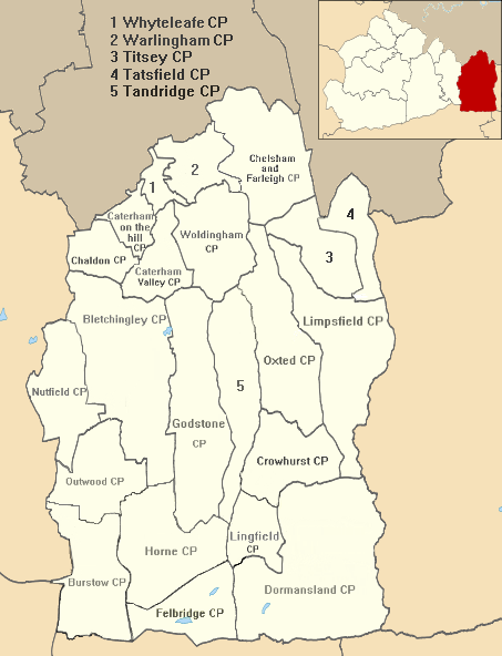
| Town, village or neighbourhood | Parish 1 | Parish 2 |
|---|---|---|
| Bletchingley which includes South Park, Brewer Street and Warwick Wold | Bletchingley | |
| Burstow which includes Smallfield** and Weatherhill | Burstow | |
| Caterham | Caterham on the Hill | Caterham Valley |
| Chaldon | Chaldon | |
| Chelsham | Chelsham and Farleigh | |
| Crowhurst | Crowhurst | |
| Dormansland which includes Dormans Park and Haxted | Dormansland | |
| Farleigh which includes Fickleshole | Chelsham and Farleigh | |
| Felbridge which includes Domewood | Felbridge | |
| Godstone which includes South Godstone*, Tyler's Green, Church Town, Tilburstow and Blindley Heath* | Godstone | |
| Horne which includes Newchapel and Whitewood | Horne | |
| Limpsfield which includes Limpsfield Chart*, Paines Hill and Langhurst | Limpsfield | |
| Lingfield which includes Felcourt | Lingfield | |
| Outwood | Outwood | |
| Oxted which includes Hurst Green* and Holland | Oxted | |
| Nutfield which includes South Nutfield* and Ridge Green | Nutfield | |
| Tandridge which includes Crowhurst Lane End | Tandridge | |
| Tatsfield | Tatsfield | |
| Titsey | Titsey | |
| Warlingham which includes Hamsey Green* | Warlingham | |
| Whyteleafe | Whyteleafe | |
| Woldingham which includes Woldingham Garden Village | Woldingham | |
Each civil parish is named after one of its towns or villages which has been established around an Anglican church. All other settlements/neighbourhoods with their own Anglican church or chapel and therefore traditionally in England defined as "a village" are marked with an asterisk. A double asterisk indicates the locality has a church hall used as a Church of England church.[8] One chapel in Limpsfield ecclesiastical parish and civil parish has no adjoining settlement, in Staffhurst Wood.
Arms
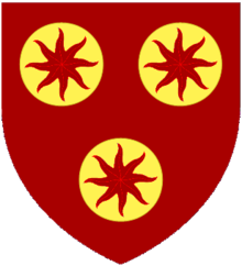 |
|
See also
- List of places of worship in Tandridge (district)
References
- Office for National Statistics: Neighbourhood Statistics: Tandridge
- Local Authority Map. Accessed 2012-04-23
- London Green Belt Council http://londongreenbeltcouncil.org.uk/threats_map/
- District Council link to external website. Accessed 2012-04-23
- "Tandridge". BBC News Online. Retrieved 9 March 2015.
- Councillor Conduct Tandridge District Council
- Map created by Ordnance Survey, courtesy of English Heritage
- Church of England website - ecclesiastical parish finder
- "Tandridge District Council (Surrey)". Civic Heraldry of England. Retrieved 31 May 2022.
External links
Districts of South East England | ||
|---|---|---|
| Berkshire |  | |
| Buckinghamshire |
| |
| East Sussex | ||
| Hampshire |
| |
| Isle of Wight | ||
| Kent | ||
| Oxfordshire | ||
| Surrey | ||
| West Sussex | ||
На других языках
[de] Tandridge District
Tandridge ist ein District in der Grafschaft Surrey in England, der im Norden an Greater London grenzt. Verwaltungssitz ist Oxted; weitere bedeutende Orte sind Bletchingley, Caterham (Surrey), Chaldon, Dormansland, Godstone, Hurst Green, Limpsfield, Lingfield, Tatsfield, Warlingham, Whyteleafe und Woldingham. Benannt ist der Bezirk nach dem Dorf Tandridge, das sich ungefähr im Zentrum befindet.- [en] Tandridge District
[ru] Тандридж
Тандридж (англ. Tandridge) — неметрополитенский район (англ. non-metropolitan district) в графстве Суррей (Англия). Административный центр — город Окстед.Другой контент может иметь иную лицензию. Перед использованием материалов сайта WikiSort.org внимательно изучите правила лицензирования конкретных элементов наполнения сайта.
WikiSort.org - проект по пересортировке и дополнению контента Википедии