world.wikisort.org - Vereinigtes_Königreich
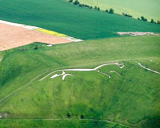
Vale of White Horse („Tal des weißen Pferdes“) ist ein District in der Grafschaft Oxfordshire in England und nach dem Scharrbild Uffington White Horse benannt. Verwaltungssitz ist Abingdon; weitere bedeutende Orte sind Grove, Faringdon und Wantage.
| Vale of White Horse District | |
|---|---|
 Lage in Oxfordshire | |
| Status | District |
| Region | South East England |
| Verw.grafschaft | Oxfordshire |
| Verwaltungssitz | Abingdon |
| Fläche | 577,62 km² |
| Einwohner | 120.988 (2011) |
| ONS-Code | 38UE |
| Website | www.whitehorsedc.gov.uk |
Geschichte
Der Bezirk wurde am 1. April 1974 gebildet und entstand aus der Fusion des Municipal Borough Abingdon, des Urban District Wantage, der Rural Districts Abingdon und Faringdon sowie eines Teils des Rural District Wantage. Vor 1974 gehörte das gesamte Gebiet zur Verwaltungsgrafschaft Berkshire.
Gliederung
Der Bezirk gliedert sich in 69 Gemeinden (Civil Parish):
|
|
|
Von diesen haben 51 einen eigenen, Ardington und Lockinge einen gemeinsamen Gemeinderat (Parish Council). Die übrigen 17 haben kein derartiges Gremium, stattdessen finden Einwohnerversammlungen statt. Abingdon on Thames, Great Faringdon und Wantage sind Kleinstädte (Town), dementsprechend heißt der Rat dort Town Council.[1]
Weblinks
- Offizielle Website des District Councils (englisch)
- Statistische Daten auf Basis der Volkszählung 2011 auf der Website des Office for National Statistics (englisch)
- District Vale of White Horse in der Datenbank des Ordnance Survey (englisch)
Einzelnachweise
- Parish councils auf der Website des Districts, abgerufen am 29. März 2018 (englisch)
На других языках
- [de] Vale of White Horse
[en] Vale of White Horse
The Vale of White Horse is a local government district of Oxfordshire in England. It was historically a north-west projection of Berkshire. The area is commonly referred to as the 'Vale of the White Horse'. It is crossed by the Ridgeway National Trail in its far south, across the North Wessex Downs AONB at the junction of four counties. The northern boundary is defined by the River Thames. The name refers to Uffington White Horse, a prehistoric hill figure.[ru] Вейл-оф-Уайт-Хорс
Вейл-оф-Уайт-Хорс (англ. Vale of White Horse) — неметрополитенский район (англ. non-metropolitan district) в графстве Оксфордшир (Англия). Административный центр — город Абингдон.Другой контент может иметь иную лицензию. Перед использованием материалов сайта WikiSort.org внимательно изучите правила лицензирования конкретных элементов наполнения сайта.
WikiSort.org - проект по пересортировке и дополнению контента Википедии