world.wikisort.org - Ukraine
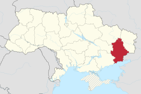
The Donetsk Oblast (Ukrainian: Донецька область, romanized: Donetska oblast, IPA: [doˈnɛtsʲkɐ ˈɔblɐsʲtʲ]), also referred to as Donechchyna (Ukrainian: Донеччина), is an oblast of eastern Ukraine. Its administrative centre is Donetsk; however, its Regional State Administration has been temporarily relocated to Kramatorsk because of the ongoing Russo-Ukrainian war.[3] Historically, the region has been an important part of the Donbas region. From its creation in 1938 until November 1961, it bore the name Stalino Oblast as Donetsk was then named "Stalino", in honour of Joseph Stalin. As part of the de-Stalinization process, it was renamed after the Siversky Donets river, the main artery of Eastern Ukraine.
Donetsk Oblast
Донецька область | |
|---|---|
Oblast | |
| Donetska oblast[1] | |
 Flag  Coat of arms | |
| Nickname: Донеччина (Donechchyna) | |
 | |
| Coordinates: 48.14°N 37.74°E | |
| Country | |
| Established | 3 June 1938 |
| Administrative center | |
| Government | |
| • Governor | Pavlo Kyrylenko[2] |
| • Oblast council | 150 seats |
| Area | |
| • Total | 26,517 km2 (10,238 sq mi) |
| • Rank | Ranked 11th |
| Population | |
| • Total | unknown |
| Demographics | |
| • Official language(s) | Ukrainian |
| • Average salary | UAH 1161 (2006) |
| Time zone | UTC+2 (EET) |
| • Summer (DST) | UTC+3 (EEST) |
| Postal code | 83000–87999 |
| Area code | +380-62 |
| ISO 3166 code | UA-14 |
| Vehicle registration | АН |
| Raions | 18 |
| Cities (total) | 52 |
| • Regional cities | 28 |
| Urban-type settlements | 131 |
| Villages | 1124 |
| FIPS 10-4 | UP05 |
| Website | dn.gov.ua |
The oblast is known for its urban sprawl of Donetsk–Makiivka and Horlivka–Yenakiieve and it is often associated with the coal mining industry.
The war in Donbas and the subsequent 2022 Russian invasion of Ukraine has seen parts of the oblast come under the control of the self-proclaimed Donetsk People's Republic and Russia, with the administrative center relocated to Mariupol then to Kramatorsk.[4] The oblast is notable for heavy fighting during the Battle of Donbas (2022).
On 30 September 2022 Russia annexed the Donetsk (DPR), Luhansk (Luhansk People's Republic), Zaporizhzhia, and Kherson Oblasts. However, the staged referendums and subsequent annexations are internationally unrecognized, and Ukraine still controls much of the province. The United Nations General Assembly subsequently passed a resolution calling on countries not to recognise what it described as an "attempted illegal annexation" and demanded that Russia "immediately, completely and unconditionally withdraw".[5]
History
Before the establishment of the Donetsian Oblast, three districts (okruhas) existed on its territory from 1923 to 1930. The Donets Governorate was terminated in 1925. As part of Soviet Ukraine, the Donetsian Oblast was established on 2 July 1932 out of the Kharkiv Oblast, the Dnipropetrovsk Oblast and a number of raions that were under the direct administration of Kharkiv (then-capital of Soviet Ukraine). Artemivsk (today Bakhmut) served as the Oblast's administrative center for two weeks until 16 July 1932, when the city of Stalino (today Donetsk) took on the role. Until 1938, the Donetsian Oblast included the territories of the modern Donetsk Oblast and the Luhansk Oblast. In June 1938 it was split into the Stalino Oblast (modern Donetsk Oblast) and the Voroshylovhrad Oblast (modern Luhansk Oblast).
During the Nazi German occupation from fall 1941 to fall 1943, Donetsk Oblast was known as Yuzivka Oblast (after the original name of Donetsk).
As part of de-Stalinization in the Soviet Union, in 1961 Stalino along with Stalino Oblast were renamed into Donetsk and Donetsk Oblast, respectively.
During the dissolution of the Soviet Union, 83.9% of voters in Donetsk Oblast approved Ukraine's declaration of independence in the 1991 referendum.[6]
In the mid-1990s, the region became known for its heightened criminal activity, including the killings of high-profile business people such as Akhat Bragin and Yevhen Shcherban. Donetsk Oblast was also a base for Ukraine's main pro-Russian political faction, Party of Regions, which became part of the Ukrainian government in 2002 and paved a way into Ukrainian politics for the powerful "Donetsk political clan".
In late 2004, the Party of Regions was involved in the creation of a political project, South-East Ukrainian Autonomous Republic, which intended to include Donetsk Oblast. Having close ties with the Russian government, the Party of Regions along with local communists and pro-Russian activists instigated the pro-Russian unrest which escalated into the war in Donbas. In May 2014 Ukraine lost control over its border with Russia in Donetsk Oblast. Currently, portions of the region are controlled by the Novorossiya Armed Forces and claimed by the self-proclaimed Donetsk People's Republic.[citation needed]
Geography
Donetsk Oblast is located in southeastern Ukraine. The area of the oblast (26,517 km2), comprises about 4.4% of the total area of the country. The oblast borders the Dnipropetrovsk and Zaporizhzhia Oblasts on the southwest, the Kharkiv Oblast on the north, the Luhansk Oblast on the northeast, the Rostov Oblast in Russia on the east, and with the Sea of Azov on the south.
Its longitude from north to south is 270 km, from east to west – 190 km. The extreme points of the oblast's borders are: Bilosarayska Kosa (spit) on the south, Shevchenko of Velykonovosilkivskyi Raion on the west, Verkhnyi Kut of Shakhtarskyi Raion on the east, and Lozove of Lyman Raion on the north.
The state historic-architectural preserve near the city of Sviatohirsk with the Sviatohirsk Lavra was nominated for the Seven Wonders of Ukraine.


Administrative divisions
The province is primarily divided into 18 raions (districts) and 28 municipalities of equal status (22 miskradas[what language is this?] and 6 mistos – cities of regional significance), including the provincial administrative center Donetsk. These are listed below with their areas and populations.[7]
| Name | Local Name | Area (km2) | Population Census 2001 | Population Estimate[7] 1 Jan 2012 | Admin.ctr |
|---|---|---|---|---|---|
| Avdiivka | Авдіївка (місто) | 29 | 37,237 | 35,257 | — |
| Bakhmut | Бахмут (Міськрада) | 74 | 113,785 | 104,631 | Bakhmut |
| Debaltseve | Дебальцеве (Міськрада) | 38 | 53,412 | 46,302 | Debaltseve |
| Dobropillia | Добропілля (Міськрада) | 119 | 72,817 | 63,938 | Dobropillia |
| Dokuchaievsk | Докучаївськ (Міськрада) | 47 | 25,024 | 24,506 | Dokuchaevsk |
| Donetsk | Донецьк (Міськрада) | 571 | 1,024,678 | 971,096 | Donetsk |
| Druzhkivka | Дружківка (Міськрада) | 23 | 75,006 | 70,126 | Druzhkivka |
| Horlivka | Горлівка (Міськрада) | 422 | 312,284 | 279,500 | Horlivka |
| Khartsyzk | Харцизьк (Міськрада) | 207 | 113,685 | 105,104 | Khartsyzk |
| Kirovske (Krestivka) | Кіровське (місто) | 7 | 31,041 | 28,470 | — |
| Kostiantynivka | Костянтинівка (місто) | 66 | 94,886 | 78,114 | — |
| Kramatorsk | Краматорськ (Міськрада) | 356 | 215,729 | 199,020 | Kramatorsk |
| Lyman | Лиман (Міськрада) | 192 | 28,996 | 23,740 | Lyman |
| Makiivka | Макіївка (Міськрада) | 426 | 431,023 | 394,604 | Makiivka |
| Mariupol | Маріуполь (Міськрада) | 244 | 510,835 | 486,320 | Mariupol |
| Myrnohrad | Мирноград (Міськрада) | 20 | 56,702 | 50,995 | Myrnohrad |
| Novohrodivka | Новогродівка (місто) | 6 | 17,559 | 15,560 | — |
| Pokrovsk | Покровськ (Міськрада) | 39 | 82,830 | 77,891 | Pokrovsk |
| Selydove | Селидове (Міськрада) | 108 | 62,819 | 54,626 | Selydove |
| Shakhtarsk | Шахтарськ (Міськрада) | 51 | 72,711 | 61,234 | Shakhtarsk |
| Sloviansk | Слов'янськ (Міськрада) | 74 | 142,873 | 138,450 | Sloviansk |
| Snizhne | Сніжне (Міськрада) | 189 | 83,046 | 71,277 | Snizhne |
| Toretsk | Торецьк (Міськрада) | 62 | 86,281 | 74,435 | Toretsk |
| Torez | Торез (Міськрада) | 105 | 96,026 | 81,761 | Torez |
| Vuhledar | Вугледар (місто) | 5 | 17,518 | 15,477 | — |
| Yasynuvata | Яcинувата (місто) | 19 | 36,903 | 35,843 | — |
| Yenakiieve | Єнакієве (Міськрада) | 425 | 162,778 | 132,110 | Yenakiieve |
| Zhdanivka | Жданівка (Міськрада) | 2 | 14,375 | 13,377 | Zhdanivka |
| Amvrosiivsky (raion) | Амвросіївський (район) | 1,455 | 54,939 | 46,081 | Amvrosiivsk |
| Bakhmutsky (raion) | Бахмутський (район) | 1,687 | 54,065 | 45,367 | Bakhmut |
| Dobropilsky (raion) | Добропільський (район) | 949 | 20,659 | 16,980 | Dobropillia |
| Kostyantynivsky (raion) | Костянтинівський (район) | 1,172 | 21,132 | 19,256 | Kostiantynivka |
| Lymansky (raion) | Лиманський (район) | 1,018 | 24,974 | 22,136 | Lyman |
| Marynsky (raion) | Мар'їнський (район) | 1,350 | 90,045 | 84,571 | Marïnka |
| Novoazovsky (raion) | Новоазовський (район) | 1,000 | 38,902 | 36,066 | Novoazovsk |
| Oleksandrivsky (raion) | Олександрівський (район) | 1,010 | 23,036 | 19,804 | Oleksandrivka |
| Pershotravnevy (raion) | Першотравневий (район) | 792 | 29,312 | 27,325 | Manhush |
| Shakhtarsky (raion) | Шахтарський (район) | 1,194 | 24,262 | 19,974 | Shakhtarsk |
| Pokrovsk (raion) | Покровський (район) | 1,316 | 37,567 | 32,439 | Pokrovsk |
| Slovyansky (raion) | Слов'янський (район) | 1,274 | 39,188 | 34,334 | Sloviansk |
| Starobeshivsky (raion) | Старобешівський (район) | 1,255 | 55,952 | 51,068 | Starobesheve |
| Telmanivsky (raion) | Тельманівський (район) | 1,340 | 35,365 | 29,965 | Telmanove |
| Velikonovosilkivsky (raion) | Великоновосілівський (район) | 1,901 | 49,323 | 41,943 | Velyka Novosilka |
| Volnovasky (raion) | Волноваський (район) | 1,848 | 92,489 | 84,579 | Volnovakha |
| Volodarsky (raion) | Володарський (район) | 1,221 | 31,168 | 29,472 | Volodarske |
| Yasynuvatsky (raion) | Ясинуватський (район) | 809 | 30,326 | 16,980 | Yasynuvata |
| Total Oblast | Донецька (Область) | 26,517 | 4,825,563 | 4,403,178 | Donetsk |
The province's secondary division consists of various municipalities that are governed by their councils. Those municipalities may consist of one or more populated places. All are administratively subordinate to the raion in which they are located.
The following data incorporates the number of each type of second-level administrative divisions of Donetsk Oblast:
- total of Settlements – 1,283, including:
- Villages – 1,124;
- Cities/Towns – 159, including:
- Urban-type settlement – 131;
- Cities of raion subordinance – 24;
- Selsovets – N/A.
The local administration of the oblast' is controlled by the Donetsk Oblast Rada. The governor of the oblast' is the Head of Donetsk Oblast administration, appointed by the President of Ukraine.
Cities
Largest cities or towns in Donetsk Oblast Source? | |||||||||
|---|---|---|---|---|---|---|---|---|---|
| Rank | Name | Raion | Pop. | ||||||
 Donetsk  Mariupol |
1 | Donetsk | Donetsk* | 975,959 |  Makiivka  Horlivka | ||||
| 2 | Mariupol | Mariupol* | 461,810 | ||||||
| 3 | Makiivka | Makiivka* | 353,918 | ||||||
| 4 | Horlivka | Horlivka* | 256,714 | ||||||
| 5 | Kramatorsk | Kramatorsk* | 164,283 | ||||||
| 6 | Sloviansk | Sloviansk* | 117,445 | ||||||
| 7 | Yenakiieve | Yenakiieve* | 82,629 | ||||||
| 8 | Bakhmut | Bakhmut* | 77,620 | ||||||
| 9 | Kostiantynivka | Kostiantynivka* | 77,066 | ||||||
| 10 | Pokrovsk | Pokrovsk* | 64,895 | ||||||
Demographics

In 2013, the population of Donetsk Oblast was 4.43 million, which constituted 10% of the overall Ukrainian population, making it the most populous and most densely populated region of the country. Its large population is due to the presence of several big industrial cities and numerous villages agglomerated around them.
During the 2004 presidential election, political supporters of Viktor Yanukovych threatened to demand autonomy for Donetsk and neighboring oblasts if the election of their candidate was not recognised. However, no official moves were ever made.
At the 2001 Ukrainian National Census, the ethnic groups within the Donetsk Oblast were: Ukrainians – 2,744,100 (56.9%), Russians – 1,844,400 (38.2%), Pontic Greeks – 77,500 (1.6%), Belarusians – 44,500 (0.9%), others (2.3%).[8]
At the 2001 census, the languages spoken within the oblast were: Russian — 74.9%, Ukrainian – 24.1%.[8] [citation needed]
The oblast also contains 21% of the country's Muslims.[8] [citation needed]
| Year | Fertility | Birth | Year | Fertility | Birth | Year | Fertility | Birth |
|---|---|---|---|---|---|---|---|---|
| 1990 | 1,6 | 58 050 | 2000 | 0,9 | 30 042 | 2010 | 1,2 | 41 258 |
| 1991 | 1,5 | 54 466 | 2001 | 0,9 | 29 931 | 2011 | 1,3 | 41 720 |
| 1992 | 1,4 | 50 258 | 2002 | 0,9 | 31 216 | 2012 | 1,3 | 42 839 |
| 1993 | 1,3 | 46 344 | 2003 | 0,9 | 33 433 | |||
| 1994 | 1,2 | 43 195 | 2004 | 1,0 | 35 526 | |||
| 1995 | 1,1 | 38 808 | 2005 | 1,0 | 35 883 | |||
| 1996 | 1,1 | 36 349 | 2006 | 1,1 | 39 327 | |||
| 1997 | 1,0 | 34 347 | 2007 | 1,2 | 40 560 | |||
| 1998 | 1,0 | 33 518 | 2008 | 1,3 | 44 394 | |||
| 1999 | 0,9 | 30 503 | 2009 | 1,3 | 43 373 |
Age structure
- 0–14 years: 12.6%
 (male 283,584/female 266,977)
 - 15–64 years: 70.4%
 (male 1,453,273/female 1,619,241)
 - 65 years and over: 17.0%
 (male 243,048/female 496,434) (2013 official)
Median age
- total: 41.9 years
- male: 38.0 years
- female: 45.8 years (2013 official)
Economy
Industry
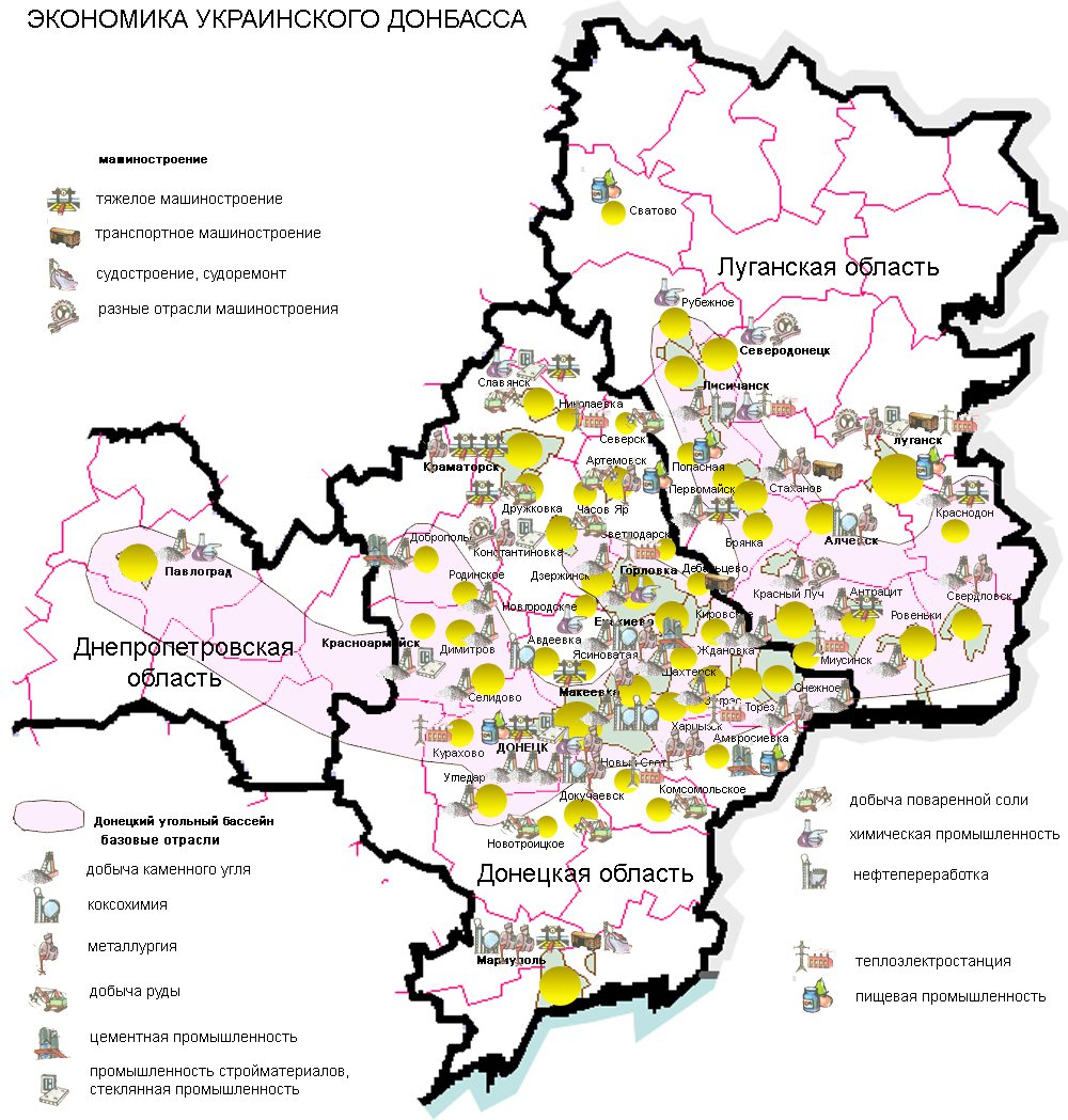
The Donetsk Oblast accounts for more than one half of the coal, finished steel, coke, cast iron and steel production in Ukraine. Ferrous metallurgy, fuel industry and power industry are in demand in the structure of industry production. There are about 882 industry enterprises that are on independent balance, and 2,095 small industry enterprises in the oblast.[9]
The oblast has a developed transport infrastructure which includes the Donetsk railway (covers 40% of national transportation), the Mariupol Port, the Donetsk International Airport, passenger airports in Mariupol and Kramatorsk, and dense road systems. In the Donetsk Oblast two special economic zones have been created, Donetsk and Azov, which have a privileged tax regime.[9]
Agriculture
In 1999, the gross grain yield in the oblast was about 999.1 thousand tons, sugar beets – 27.1 thousand tons, sunflower seeds – 309.4 thousand tons, and potatoes – 380.2 thousand tons.[9] Also, 134.2 thousand tons of meat, 494.3 thousand tons of milk and 646.4 million eggs have been produced. At the beginning of 1999 there were 2108 farms within the oblast.[9]
Geology
The Donetsk Oblast's climate is mostly continental, which is characterised by hot summers and relatively cold winters with changeable snow surfaces. East and southeast strong winds, high temperatures and heavy rain showers are typical in the summer. The average annual rainfall is 524 mm.
The basic minerals found here are: coal (reserves – 25 billion tons), rock salt, lime carbonate, potassium, mercury, asbestos, and graphite. The area is also rich in fertile black earth.
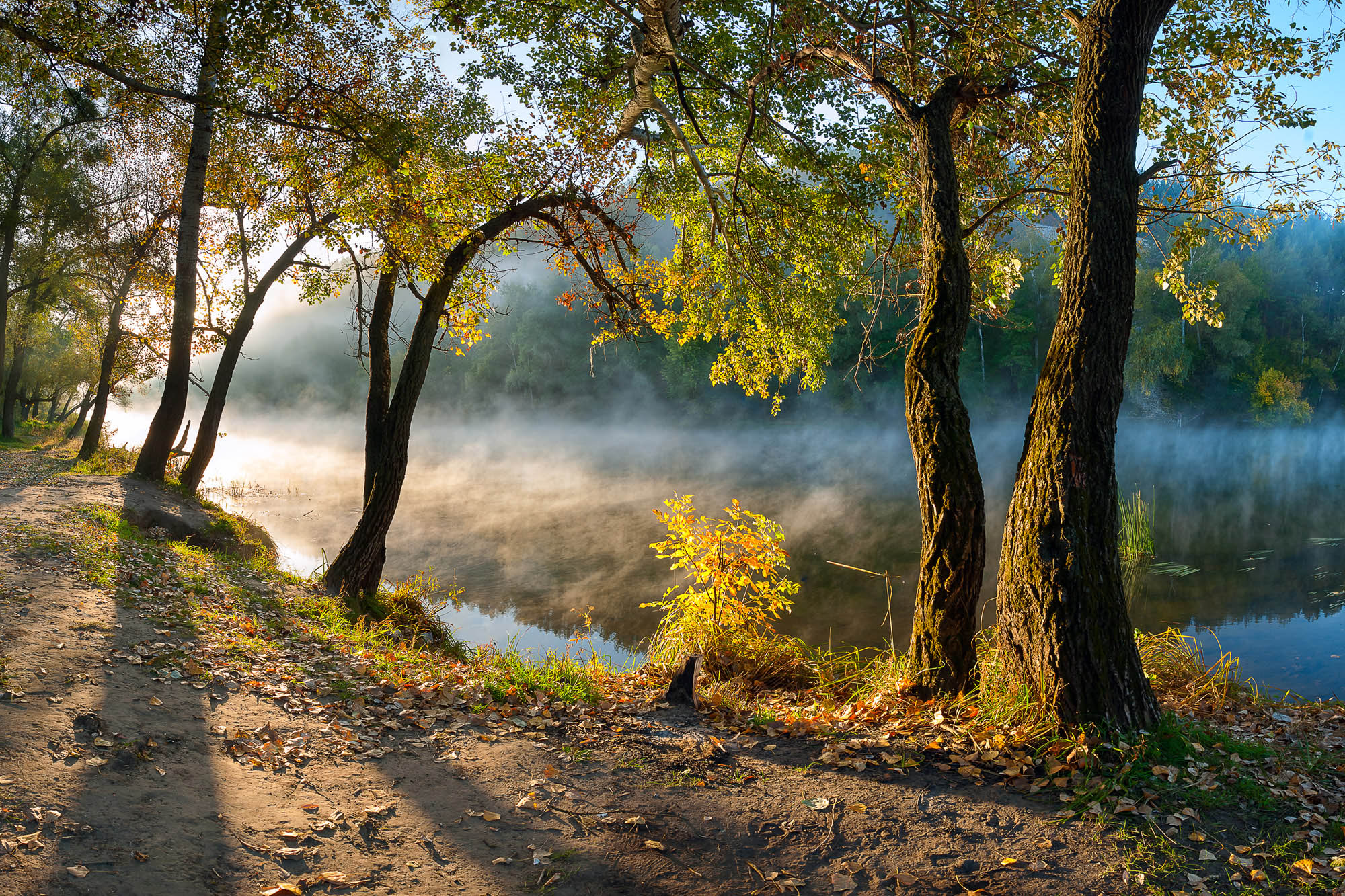
Important resources for recreation within the area are: the mild climate, the Sea of Azov coast, curative mud, sources of minerals, and radon and table water. Due to these numerous recreation resources, many resort hotels and camps are located here. There are about 26 health centres and pensions, 52 rest homes and boarding houses, and rest camps for children in the oblast.[9]
The curative[clarification needed] areas in the oblast include the Slovyansk salt lakes and mineral water sources. The oblast also contains many park zones, some of which are of great national value. They include the Khomutivsky steppe and the Azov sea coast. Overall, the Donetsk Oblast contains about 70 protected park and nature attractions including branches of the Ukrainian steppe park, six state reserves, ten memorials of nature, landscapes, and six park tracts.[9]
Polls
During the 1991 referendum, 83.90% of votes in Donetsk Oblast were in favour of the Declaration of Independence of Ukraine, fourth lowest in the country after Crimea, Sevastopol and Luhansk Oblast. A survey conducted in December 2014 by the Kyiv International Institute of Sociology found 18.5% of the oblast's population supported their region joining Russia, 53.8% did not support the idea, 22.5% were undecided, and 5.2% did not respond; insurgent-controlled areas (which hold over 50% of the population)[10] were not polled.[11]
See also
- Administrative divisions of Ukraine
- List of cities in Donetsk Oblast
References
- Syvak, Nina; Ponomarenko, Valerii; Khodzinska, Olha; Lakeichuk, Iryna (2011). Veklych, Lesia (ed.). Toponymic Guidelines for Map and Other Editors for International Use (PDF). United Nations Statistics Division. scientific consultant Iryna Rudenko; reviewed by Nataliia Kizilowa; translated by Olha Khodzinska. Kyiv: DerzhHeoKadastr and Kartographia. p. 20. ISBN 978-966-475-839-7. Retrieved 6 October 2020.
- "High-quality infrastructure and timely payment of salaries and pensions: President set tasks for newly appointed Donetsk RSA Head Pavlo Kyrylenko". president.gov.ua. 5 July 2019. Retrieved 8 July 2019.
- Kikhtenko to move Donetsk administration to Kramatorsk and to leave power structures in Mariupol Archived 19 October 2017 at the Wayback Machine Mirror Weekly, mw.ua
- "Kikhtenko to move Donetsk administration to Kramatorsk and to leave power structures in Mariupol". Dzerkalo Tyzhnia (in Russian). Archived from the original on 19 October 2017. Retrieved 3 November 2014.
- "Ukraine: UN General Assembly demands Russia reverse course on 'attempted illegal annexation'". 12 October 2022.
- "Independence – over 90% vote yes in referendum; Kravchuk elected president of Ukraine]". The Ukrainian Weekly. 8 December 1991. Archived from the original on 19 October 2017. Retrieved 4 January 2017.
- State Statistics Committee of Ukraine, Kiev.
- Ukrcensus.gov.ua — Donetsk region URL accessed on 13 January 2007
- Cabinet of Ministers of Ukraine — Donetsk Region URL accessed on 13 January 2007
- "Self-proclaimed Luhansk People's Republic governs most residents". TASS. 25 September 2014. Retrieved 29 March 2018.
- Лише 3% українців хочуть приєднання їх області до Росії [Only 3% of Ukrainians want their region to become part of Russia]. Dzerkalo Tyzhnia (in Ukrainian). 3 January 2015.
External links
 Definitions from Wiktionary
 Media from Commons
 News from Wikinews
 Quotations from Wikiquote
 Texts from Wikisource
 Textbooks from Wikibooks
 Resources from Wikiversity
- Information Card of the Region – Official site of the Cabinet of Ministers of Ukraine
- www.citylife.donetsk.ua – Official Donetsk city guide – English
- donoda.gov.ua – Official site of Donetsk Oblast Administration (in English, Ukrainian, and Russian)
- catalogue.biz.ua – Post codes directory of Donetsk Oblast (in English, Ukrainian, and Russian)
 Media related to Donetsk Oblast at Wikimedia Commons
Administrative center: Donetsk | ||
| Raions | ||
| Hromadas | ||
| Cities |
| |
| Urban-type settlements | ||
Capital: Kyiv | |
| Oblasts | |
| Cities with special status | |
| Autonomous republic |
|
| Administrative centers |
|
1Claimed and controlled by Russia as the Republic of Crimea and the Federal City of Sevastopol 2Partly under military occupation and controlled by Russia | |
War in Donbas (2014–2022) | |||||
|---|---|---|---|---|---|
Part of the Russo-Ukrainian War | |||||
| General topics |
| ||||
| Timeline |
| ||||
| Battles |
| ||||
| Other events |
| ||||
| Self-proclaimed states |
| ||||
| (Pro-) Russian |
| ||||
| Ukrainian |
| ||||
Authority control | |
|---|---|
| General | |
| National libraries | |
| Other |
|
На других языках
[de] Oblast Donezk
Die Oblast Donezk oder selten Oblast Donetsk (ukrainisch Донецька область .mw-parser-output .Latn{font-family:"Akzidenz Grotesk","Arial","Avant Garde Gothic","Calibri","Futura","Geneva","Gill Sans","Helvetica","Lucida Grande","Lucida Sans Unicode","Lucida Grande","Stone Sans","Tahoma","Trebuchet","Univers","Verdana"}Donezka oblast; russisch Донецкая область Donezkaja oblast) ist ein Verwaltungsbezirk der Ukraine. Die Oblast liegt im Donezbecken (auch Donbas), einem stark industrialisierten Gebiet, und ist eine der wirtschaftlich bedeutendsten und am dichtesten besiedelten Regionen der Ostukraine.- [en] Donetsk Oblast
[ru] Донецкая область
Доне́цкая о́бласть (укр. Доне́цька о́бласть), или Донетчина[7] (укр. Донеччина), — административно-территориальная единица Украины, расположенная на юго-востоке страны, в Донбассе.Другой контент может иметь иную лицензию. Перед использованием материалов сайта WikiSort.org внимательно изучите правила лицензирования конкретных элементов наполнения сайта.
WikiSort.org - проект по пересортировке и дополнению контента Википедии