world.wikisort.org - Ukraine
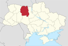
Zhytomyr Oblast (Ukrainian: Жито́мирська о́бласть, romanized: Zhytomyrska oblast), also referred to as Zhytomyrshchyna (Ukrainian: Жито́мирщина) is an oblast (province) of northern Ukraine. The administrative center of the oblast is the city of Zhytomyr. Its population is approximately 1,195,495 (2021 est.)[4].
Zhytomyr Oblast
Житомирська область | |
|---|---|
Oblast | |
| Zhytomyrska oblast[1] | |
 | |
 Flag Coat of arms | |
| Nickname: Житомирщина (Zhytomyrshchyna) | |
 | |
| Coordinates: 50.65°N 28.52°E | |
| Country | |
| Administrative center | Zhytomyr |
| Government | |
| • Governor | Vitaliy Bunechko[2] |
| • Oblast council | 64[3] seats |
| • Chairperson | Volodymyr Shyrma |
| Area | |
| • Total | 29,832 km2 (11,518 sq mi) |
| • Rank | Ranked 5th |
| Population (2021)[4] | |
| • Total | |
| • Rank | Ranked 16th |
| Time zone | UTC+2 (EET) |
| • Summer (DST) | UTC+3 (EEST) |
| Postal code | from 10 to 13 |
| Area code | +380-41 |
| ISO 3166 code | UA-18 |
| Raions | 23 |
| Cities (total) | 11 |
| • Regional cities | 5 |
| Urban-type settlements | 43 |
| Villages | 1625 |
| FIPS 10-4 | UP27 |
| Website | oda |

History
The oblast was created as part of the Ukrainian Soviet Socialist Republic on September 22, 1937, out of territories of Vinnytsia and Kyiv oblasts as well as two border okrugs of Kyiv Oblast – Korosten Okrug and Novohrad-Volynsky Okrug.
The oblast covers territories of the historic regions of Polesia, Volhynia, and Podolia, which are reflected on the oblast's coat of arms.
Before the 18th century bigger half of the oblast belonged to the Kyiv Voivodeship (Polish: Kijów), while smaller western half around the city of Novohrad-Volynskyi (Polish: Zviahel) belonged to the Volyn Voivodeship. Following the treaty of Andrusovo, the city of Zhytomyr (Polish: Zytomierz) continued to act as an administrative center of the Kyiv Voivodeship.
Following the second partition of Poland, on the newly annexed territory was formed oversized Izyaslav Vice-royalty (Russian: namestnichestvo) which included former Polish territories in Volhynia, Podolia, and Kyiv land and centered in Izyaslav. However a couple of years later the Russian Empire annexed more territories of the Polish Kingdom during the third partition of Poland contributing to the complete disappearance of the Polish statehood. The Izyaslav Vice-royalty was reformed and the territory of today's Zhytomyr Oblast predominantly ended up in the Russian Volhynian Governorate and the city of Zviahel which was renamed as Novohrad-Volynskyi (Russian: Novograd-Volynskiy) became its administrative center. Later the administrative center was transferred to the bigger city of Zhytomyr (Russian: Zhitomir).
During the 2022 Russian invasion of Ukraine Russian troops partly occupied the region.[5] They were completely repulsed when the Narodychi settlement hromada (where Russian forces had been dug in from the opening of the offensive in late February 2022) was declared liberated on 4 April 2022.[5]
Geography
The total area of Zhytomyr Oblast is 29,832 km2 (11,518 sq mi).
Among the points of interest it is important to mention the following sites that were nominated for the Seven Wonders of Ukraine:
- Church of Saint Basil the Great (Ovruch)
- Stone village state preserve
- Korolev Memorial Astronautical Museum
The Museum of Ukrainian home icons, which is the only one in Europe, is situated in Zhytomyr Oblast. It is located in Radomyshl, a small town, about 90 km (56 mi) away from Kyiv. The museum is the part of the Radomysl Castle historical and cultural complex. It was founded by Olga Bogomolets.[6]
Population
The current estimated population of the oblast is 1,268,903 (as of 2013). Zhytomyr Oblast is the most important center of the Polish minority in Ukraine, which numbers 49,000 locally.
Age structure
- 0-14 years: 15.8%
 (male 103,194/female 97,617)
 - 15-64 years: 68.1%
 (male 420,285/female 444,803)
 - 65 years and over: 16.1% (male 65,301/female 138,472) (2013 official)
Median age
- total: 39.4 years
- male: 36.1 years
- female: 42.6 years (2013 official)
Economy
The economy of Zhytomyr Oblast mostly deals with mining of granite and other construction stone, forestry, agriculture and various machinery manufacturing.
The northern part of the province is highly affected by the Chernobyl disaster: some of the towns and raions are devastated and are included in the Chernobyl zone, while others are prohibited from producing their own agriculture.
Administrative divisions
Zhytomyr Oblast is subdivided into 4 raions (districts).
The districts of Zhytomyr oblast include:
- Berdychiv Raion (Ukrainian: Бердичівський район, translit. Berdychivs’kyi raion)
- Korosten Raion (Ukrainian: Коростенський район, translit. Korostens’kyi raion)
- Novohrad-Volynskyi Raion (Ukrainian: Новоград-Волинський район, translit. Novohrad-Volyns’kyi raion)
- Zhytomyr Raion (Ukrainian: Житомирський район, translit. Zhytomyrs’kyi raion)
Important cities

Important cities of Zhytomyr Oblast include:
Nomenclature
Most of Ukraine's oblasts are named after their capital cities, officially referred to as "oblast centers" (Ukrainian: обласний центр, translit. oblasnyi tsentr). The name of each oblast is a relative adjective, formed by adding a feminine suffix to the name of respective center city: Zhytomyr is the center of the Zhytomyrs'ka oblast' (Zhytomyr Oblast). Most oblasts are also sometimes referred to in a feminine noun form, following the convention of traditional regional place names, ending with the suffix "-shchyna", as is the case with Zhytomyr Oblast, Zhytomyrshchyna.
References
- Syvak, Nina; Ponomarenko, Valerii; Khodzinska, Olha; Lakeichuk, Iryna (2011). Veklych, Lesia (ed.). "Toponymic Guidelines for Map and Other Editors for International Use" (PDF). United Nations Statistics Division. scientific consultant Iryna Rudenko; reviewed by Nataliia Kizilowa; translated by Olha Khodzinska. Kyiv: DerzhHeoKadastr and Kartographia. p. 20. ISBN 978-966-475-839-7. Retrieved 2020-10-06.
- Volodymyr Zelenskyy introduced new Zhytomyr RSA Head Vitaliy Bunechko Office of the President of Ukraine (12 August 2019)
- Oblast Council website
- Чисельність наявного населення України на 1 січня 2021 / Number of Present Population of Ukraine, as of January 1, 2021 (PDF) (in Ukrainian and English). Kyiv: State Statistics Service of Ukraine.
- (in Ukrainian) Zhytomyr region is liberated from Russian troops - the head of the Regional Military administration, Ukrayinska Pravda (4 April 2022)
- Богомолець. О. "Замок-музей Радомисль на Шляху Королів Via Regia". — Київ, 2013
External links
Administrative center: Zhytomyr | ||
| Raions |
| |
| Hromadas | ||
| Cities |
| |
| Urban-type settlements |
| |
Capital: Kyiv | |
| Oblasts |
|
| Cities with special status |
|
| Autonomous republic |
|
| Administrative centers |
|
1Claimed and controlled by Russia as the Republic of Crimea and the Federal City of Sevastopol 2Partly under military occupation and controlled by Russia | |
Authority control | |
|---|---|
| General | |
| National libraries | |
| Other |
|
На других языках
[de] Oblast Schytomyr
Die Oblast Schytomyr (ukrainisch Житомирська область .mw-parser-output .Latn{font-family:"Akzidenz Grotesk","Arial","Avant Garde Gothic","Calibri","Futura","Geneva","Gill Sans","Helvetica","Lucida Grande","Lucida Sans Unicode","Lucida Grande","Stone Sans","Tahoma","Trebuchet","Univers","Verdana"}Schytomyrska oblast, russisch Житомирская область Schitomirskaja oblast) ist eine Verwaltungseinheit im Norden der Ukraine. Sie hat 1.195.495 Einwohner (Anfang 2021; de facto).[1]- [en] Zhytomyr Oblast
[ru] Житомирская область
Жито́мирская о́бласть (укр. Жито́мирська о́бласть), разг. Жито́мирщина (укр. Жито́мирщина) — область на северо-западе Украины. Административный центр области — город Житомир.Другой контент может иметь иную лицензию. Перед использованием материалов сайта WikiSort.org внимательно изучите правила лицензирования конкретных элементов наполнения сайта.
WikiSort.org - проект по пересортировке и дополнению контента Википедии