world.wikisort.org - Ukraine
Siversk (Ukrainian: Сі́верськ, pronounced [ˈs⁽ʲ⁾i.wersʲk]; Russian: Се́верск, tr. Seversk; until 1973: Yama [Я́ма; Я́ма]) is a city in Bakhmut Raion of Donetsk Oblast (province) of Ukraine situated 99 km north of Donetsk. Population: 10,875 (2022 est.)[1]; 12,608 (2010).[2]
This article needs additional citations for verification. (October 2011) |
Siversk | |
|---|---|
 Railway station in Siversk | |
 Flag  Coat of arms | |
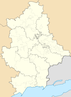 Siversk Location of Siversk  Siversk Siversk (Ukraine) | |
| Coordinates: 48°51′47″N 38°5′50″E | |
| Country | |
| Oblast | |
| Raion | |
| Foundation | 1913 |
| City rights | 1961 |
| Government | |
| • Mayor | Oleksandr Gura |
| Area | |
| • Total | 11 km2 (4 sq mi) |
| Elevation | 72 m (236 ft) |
| Population (2022) | |
| • Total | 10,875 |
| • Density | 990/km2 (2,600/sq mi) |
| Postal code | 84522-84524 |
| Area code | +380 6274 |
 | |
There are some industrial factories located within the raion, notably the Stroidetal brick factory. Siversk is a former sovhoz by the name of Yamskyi.
History
The town was founded in 1913 because of the operation of the dolomite mine near the railway station of Yama built in 1910. The town received city status in 1961 and was renamed Siversk in 1973.
On 10 July 2014, Ukrainian forces secured the town from pro-Russian separatists.[3]
Battle of Siversk
In July 2022, the city became the site of a battle between forces from Russia and the breakaway DPR and LPR against Ukrainian forces, resulting in the defeat and retreat of Russian forces.
Gallery
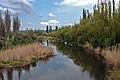 Bakhmutka river near Siversk
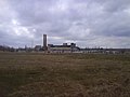 Siversk dolomite plant


Population
Recent population estimates or census results:
| Year | Pop. | ±% |
|---|---|---|
| 1989 | 14,019 | — |
| 2001 | 14,393 | +2.7% |
| 2005 | 13,478 | −6.4% |
| 2006 | 13,253 | −1.7% |
| 2007 | 13,112 | −1.1% |
| 2008 | 12,916 | −1.5% |
| 2009 | 12,742 | −1.3% |
| 2010 | 12,608 | −1.1% |
| Source: [4] | ||
References
- Чисельність наявного населення України на 1 січня 2022 [Number of Present Population of Ukraine, as of January 1, 2022] (PDF) (in Ukrainian and English). Kyiv: State Statistics Service of Ukraine.
- «Статистичний збірник "Чисельність наявного населення України на 1 січня 2010 року» [Statistical Manual: Total population, as of 1 January 2010]. "Населення України" (in Ukrainian). Archived from the original on 2012-03-05. Retrieved 2011-10-04.
- "Ukraine forces clash with separatists at Donetsk airport". BBC News. 10 July 2014.
- World Gazetteer http://world-gazetteer.com/wg.php?x=&men=gpro&lng=en&des=wg&srt=npan&col=abcdefghinoq&msz=1500&geo=499953811. Retrieved 2011-10-04.
{{cite web}}: Missing or empty|title=(help)[dead link]; State Statistics Committee of Ukraine: Статистичний збірник «Чисельність наявного населення України на 1 січня 2008 року» [Statistical Manual: Total population, as of 1 January 2008]. "Населення України" (in Ukrainian). Archived from the original on 2012-04-25. Retrieved 2012-04-25.; State Statistics Committee of Ukraine: «Статистичний збірник "Чисельність наявного населення України на 1 січня 2010 року» [Statistical Manual: Total population, as of 1 January 2010]. "Населення України" (in Ukrainian). Archived from the original on 2012-03-05. Retrieved 2011-10-04.
Administrative center: Donetsk | ||
| Raions | ||
| Hromadas | ||
| Cities |
| |
| Urban-type settlements | ||
War in Donbas (2014–2022) | |||||
|---|---|---|---|---|---|
Part of the Russo-Ukrainian War | |||||
| General topics |
| ||||
| Timeline |
| ||||
| Battles |
| ||||
| Other events |
| ||||
| Self-proclaimed states |
| ||||
| (Pro-) Russian |
| ||||
| Ukrainian |
| ||||
This article about a location in Donetsk Oblast is a stub. You can help Wikipedia by expanding it. |
На других языках
[de] Siwersk
Siwersk (ukrainisch Сіверськ; russisch Северск .mw-parser-output .Latn{font-family:"Akzidenz Grotesk","Arial","Avant Garde Gothic","Calibri","Futura","Geneva","Gill Sans","Helvetica","Lucida Grande","Lucida Sans Unicode","Lucida Grande","Stone Sans","Tahoma","Trebuchet","Univers","Verdana"}Sewersk) ist eine Stadt im Norden der ukrainischen Oblast Donezk mit etwa 12.000 Einwohnern (2014).[1] Die 1913 gegründete Ortschaft liegt im Rajon Bachmut an der Territorialstraße T–05–13 und am Ufer der Bachmutka, einem 88 km langen Nebenfluss des Siwerskyj Donez, 36 km nordwestlich vom Rajonzentrum Bachmut. Siwersk erhielt 1961 den Status einer Stadt. Die Stadt besitzt einen Bahnhof an der Bahnstrecke Charkiw–Horliwka, außerdem beginnt hier die Bahnstrecke Siwersk–Lichaja.- [en] Siversk
[es] Síversk
Síversk (en ucraniano, Сі́верськ) es una localidad del raión de Bajmut, en el óblast de Donetsk, Ucrania.[ru] Северск (Украина)
Се́верск (укр. Сі́верськ; до 1973 года — Я́ма) — город в Бахмутском районе Донецкой области Украины, административный центр Северской городской общины. До укрупнения Бахмутского района в 2020 году был городом районного значения.Другой контент может иметь иную лицензию. Перед использованием материалов сайта WikiSort.org внимательно изучите правила лицензирования конкретных элементов наполнения сайта.
WikiSort.org - проект по пересортировке и дополнению контента Википедии