world.wikisort.org - Ukraine
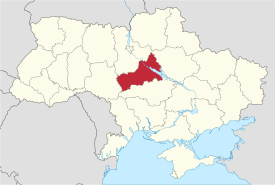
Cherkasy Oblast (Ukrainian: Черка́ська о́бласть, romanized: Cherkaska oblast, pronounced [tʃerˈkɑsʲkɐ ˈɔblɐstʲ]), also referred to as Cherkashchyna (Ukrainian: Черка́щина, [tʃerˈkɑʃtʃɪnɐ]) is an oblast (province) of central Ukraine located along the Dnieper River. The administrative center of the oblast is the city of Cherkasy. The current population of the oblast is 1,178,266 (2021 est.)[3]
Cherkasy Oblast
Черкаська область | |
|---|---|
Oblast | |
| Cherkaska oblast[1] | |
 Flag  Coat of arms | |
| Nickname(s): Шевченків край (Shevchenkiv krai) | |
 | |
| Country | |
| Established | January 7, 1954 |
| Administrative center | Cherkasy |
| Largest cities | Cherkasy, Uman, Smila, Zolotonosha |
| Government | |
| • Governor | Ihor Taburets[2] |
| • Oblast council | 84 seats |
| • Chairperson | Anatoliy Pidhornyy |
| Area | |
| • Total | 20,900 km2 (8,100 sq mi) |
| • Rank | Ranked 18th |
| Population (2021)[3] | |
| • Total | |
| • Rank | Ranked 15th |
| Demographics | |
| • Official language(s) | Ukrainian |
| • Average salary | UAH 817 (2006) |
| Time zone | UTC+2 (EET) |
| • Summer (DST) | UTC+3 (EEST) |
| Postal code | 18-20xxx |
| Area code | +380 47 |
| ISO 3166 code | UA-71 |
| Vehicle registration | CA |
| Raions | 20 |
| Cities (total) | 25 |
| • Regional cities | 6 |
| Urban-type settlements | 34 |
| Villages | 838 |
| FIPS 10-4 | UP01 |
| Website | www.oda.ck.ua www.rada.gov.ua |
Geography
With 20,900 km², Cherkasy Oblast is the 18th largest oblast of Ukraine, comprising about 3.5% of the area of the country. The south flowing Dnieper River with the hilly western bank and the plain eastern bank divides the oblast into two unequal parts. The larger western part belongs to the Dnieper Upland. The low-lying eastern part of the oblast used to be subject to the frequent Dnieper flooding before the flow of the river became controlled by multiple dams of Hydroelectric Power Plants constructed along the river in the 20th century.

The oblast extends for 245 km from south-west to north-east, and for 150 km from north to south. The northernmost point of the oblast is located is near the village of Kononivka in Zolotonosha Raion (district), the southernmost point near the village of Kolodyste in Zvenyhorodka Raion, the westernmost point near the village of Korytnya in Uman Raion, and the easternmost point near the village of Stetsivka in Cherkasy Raion. The geometric centre of the oblast is located near the village Zhuravky[citation needed] of Horodyshche Raion. The oblast borders Kyiv Oblast to the north, Kirovohrad Oblast to the south, Poltava Oblast to the east, and Vinnytsia Oblast to the west.
History
Cherkasy Oblast was created as part of the Ukrainian Soviet Socialist Republic on 7 January 1954. The oblast's territory was the major cities of Cherkasy, Smila and Uman, their corresponding raions (districts), as well as 30 former raions of the Vinnytsia, Kyiv, Kirovohrad and Poltava Oblasts.
Archaeological discoveries have shown that people have inhabited the valley of the Dnieper River since time immemorial. The oldest objects excavated on the territory of the region date back to the Stone Age – the Palaeolithic period.
Administrative divisions
Since July 2020, Cherkasy Oblast is administratively subdivided into 4 raions (districts). There are a total of 16 cities, 15 urban-type settlements, and 824 villages.
The following data incorporates the number of each type of administrative divisions of Cherkasy Oblast:
- Administrative Center—1 (Cherkasy);
- Raions—4;
- Settlements—855, including:
- Villages—824;
- Urban localities—31, including:
- Urban-type settlements—15;
- Cities—16;
- Rural councils—525.
The local administration of the oblast is controlled by the Cherkasy Oblast Rada. The governor of the oblast is the Cherkasy Oblast Rada speaker, appointed by the President of Ukraine.
Since July 2020, Cherkasy Oblast consists of four raions:
The region has 16 populated places designated as cities (towns). The only one with the population over 100 thousands is Cherkasy. Uman and Smila are in the range between 80 and 90 thousands, and all others are below 30 thousands.
Demographics

The current estimated population is 1,335,064 (as of 2006).
According to the 2001 Ukrainian census, the oblast's population is almost equally divided between the urban and rural areas (53.7% and 46.3%, respectively).[4] The demographic situation in this largely agricultural territory is somewhat complicated by population ageing.[5]
By ethnic composition, Ukrainians represent the overwhelming majority of the oblast's population (73.6%).[6] Ethnic Russians are the second group of population (25.4%), and are concentrated mainly in the city of Cherkasy.
Age structure
- 0-14 years: 13.4%
 (male 87,557/female 82,340)
 - 15-64 years: 69.1%
 (male 417,426/female 457,390)
 - 65 years and over: 17.5% (male 72,835/female 147,711) (2013 official)
Median age
- total: 41.7 years

- male: 38.4 years
- female: 45.0 years (2013 official)
Economy
The economy of the Cherkasy Oblast is largely dominated by agriculture. While the winter wheat and sugar beets are the main products grown in the oblast, barley, corn, tobacco and hemp are also grown. Cattle breeding is also important.
The industry is mainly concentrated in Cherkasy, the oblast's capital and the largest city. A chemical industry was developed in the city in late 1960s in addition to machine building, furniture making and agricultural processing.
Nomenclature
Most of Ukraine's oblasts are named after their capital cities, officially referred to as "oblast centers" (Ukrainian: обласний центр, romanized: oblasnyi tsentr). The name of each oblast is a relative adjective, formed by adding a feminine suffix to the name of respective center city: Cherkasy is the center of the Cherkaska oblast (Cherkasy Oblast). Most oblasts are also sometimes referred to in a feminine noun form, following the convention of traditional regional place names, ending with the suffix "-shchyna", as is the case with the Cherkasy Oblast, Cherkashchyna.
Education
There are 5 universities in the region:
- The Bohdan Khmelnytsky National University of Cherkasy
- Cherkasy State Technological University
- Uman National University Of Horticulture
- Pavlo Tychyna Uman State Pedagogical University
- East European University of Economics and Management (private)
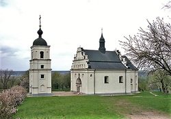
Attractions
- Sofiivka
- Fatherland of Taras Shevchenko
- Trypillian culture
- Shevchenko National preserve
- Martynivka Treasure housed in Kyiv
See also
- Administrative divisions of Ukraine
- Right and Left-bank Ukraine, historical region
References
- Syvak, Nina; Ponomarenko, Valerii; Khodzinska, Olha; Lakeichuk, Iryna (2011). Veklych, Lesia (ed.). "Toponymic Guidelines for Map and Other Editors for International Use" (PDF). United Nations Statistics Division. scientific consultant Iryna Rudenko; reviewed by Nataliia Kizilowa; translated by Olha Khodzinska. Kyiv: DerzhHeoKadastr and Kartographia. p. 20. ISBN 978-966-475-839-7. Retrieved 2020-10-06.
- Zelensky replaces heads of Odesa, Cherkasy regional state administrations, Ukrinform (2 March 2022)
- Чисельність наявного населення України на 1 січня 2021 / Number of Present Population of Ukraine, as of January 1, 2021 (PDF) (in Ukrainian and English). Kyiv: State Statistics Service of Ukraine.
- "General results of the census / Urban and rural population / Cherkasy region". 2001 Ukrainian Census. Archived from the original on 2007-09-27. Retrieved 2007-06-03.
- "General results of the census / Age composition of population / Cherkasy region". 2001 Ukrainian Census. Archived from the original on 2007-09-30. Retrieved 2007-06-03.
- "General results of the census / National composition of population / Cherkasy region". 2001 Ukrainian Census. Archived from the original on 2007-07-02. Retrieved 2007-06-03.
- "Cherkasy Region". Cabinet of Ministers of Ukraine. Retrieved 2007-06-01.
- (1972) Історіа міст і сіл Української CCP - Черкаська область (History of Towns and Villages of the Ukrainian SSR - Cherkasy Oblast), Kyiv. (in Ukrainian)
External links
- oda.ck.ua—Official website of Cherkasy Oblast Administration (in Ukrainian, Russian, and English)
- ukrainebiz.com—Cherkasy oblast: facts and figures
Administrative center: Cherkasy | ||
| Raions | ||
| Hromadas |
| |
| Cities |
| |
| Urban-type settlements |
| |
Capital: Kyiv | |
| Oblasts | |
| Cities with special status | |
| Autonomous republic |
|
| Administrative centers |
|
1Claimed and controlled by Russia as the Republic of Crimea and the Federal City of Sevastopol 2Claimed and mostly controlled by Pro-Russian separatist state of Donetsk People's Republic 3Claimed and controlled by Pro-Russian separatist state of Luhansk People's Republic 4Regions are mostly under military occupation and controlled by Russia | |
Authority control | |
|---|---|
| National libraries | |
| Other |
|
На других языках
[de] Oblast Tscherkassy
Die Oblast Tscherkassy (ukrainisch Черкаська область .mw-parser-output .Latn{font-family:"Akzidenz Grotesk","Arial","Avant Garde Gothic","Calibri","Futura","Geneva","Gill Sans","Helvetica","Lucida Grande","Lucida Sans Unicode","Lucida Grande","Stone Sans","Tahoma","Trebuchet","Univers","Verdana"}Tscherkaska oblast; russisch Черкасская область Tscherkasskaja oblast) im Zentrum der Ukraine besteht seit 1954 und ist die jüngste von 25 Verwaltungseinheiten (Oblaste) des Landes. Sie hat 1.178.266 Einwohner (Anfang 2021; de facto)[1].- [en] Cherkasy Oblast
[ru] Черкасская область
Черка́сская о́бласть (укр. Черка́ська о́бласть), разг. Черка́счина[5] (укр. Черка́щина) — регион Украины, расположенный в центральной части страны.Другой контент может иметь иную лицензию. Перед использованием материалов сайта WikiSort.org внимательно изучите правила лицензирования конкретных элементов наполнения сайта.
WikiSort.org - проект по пересортировке и дополнению контента Википедии