world.wikisort.org - Ukraine
Chyhyryn (Ukrainian: Чигирин, pronounced [tʃɪɦɪˈrɪn]) is a city and historic site located in Cherkasy Raion of Cherkasy Oblast of central Ukraine. From 1648 to 1669 the city was a Hetman residence. After a forced relocation of the Ruthenian Orthodox metropolitan see from Kyiv in 1658, it became a full-fledged capital of the Cossack Hetmanate. Chyhyryn also became a traditional place for the appointment to the office of Hetman of Zaporizhian Host. It hosts the administration of Chyhyryn urban hromada, one of the hromadas of Ukraine.[1] Population: 8,664 (2021 est.)[2]
Chyhyryn
Чигирин | |
|---|---|
 View of Chyhyryn. | |
 Flag  Coat of arms | |
 Chyhyryn Location of Chyhyryn  Chyhyryn Chyhyryn (Ukraine) | |
| Coordinates: 49°04′38″N 32°38′57″E | |
| Country | |
| Oblast | |
| Raion | Cherkasy Raion |
| City rights | 1592 |
| Government | |
| • Mayor | Serhiy Oleksiiovych Tymchenko |
| Area | |
| • Total | 14 km2 (5 sq mi) |
| Elevation | 124 m (407 ft) |
| Population (2021) | |
| • Total | 8,664 |
| • Density | 854/km2 (2,210/sq mi) |
| Postal code | 20900-20906 |
| Area code | +380 4730 |
Names
Chyhyryn (Ukrainian: Чигирин; Turkish: Çigirin or Çehrin; Russian: Чигирин) Polish: Czehryń).
Location
The city is on the banks of Tiasmyn River and lies at an altitude of 124 metres above mean sea level. Minor industries, such as food and furniture factories, are the basis of the town economy in the 21st century.
History
The area (1320–1569) had been part of the Grand Duchy of Lithuania. It was ceded to the Polish–Lithuanian Commonwealth (in the Kijów Voivodeship [Kyiv or Kiev] of the Crown of Poland) before the Union of Lublin. It was granted Magdeburg Rights in 1592 by Sigismund III Vasa.

Chyhyryn is first mentioned as a fortified Cossack winter station. In 1638, Bohdan Khmelnytsky became its starosta (regional leader), and in 1648 it became the newly elected Hetman's residence and the capital of the Cossack state, the Zaporozhian Host. During the Russo-Turkish War (1676–1681) it was the center of two bloody campaigns (1675–76 and 1677–78). In 1678 the castle of Chyhyryn was blown up by the retreating Russian garrison that was stationed there, while the Turkish forces sacked the rest of the city. After this, it gradually lost its significance. The city fell under Ottoman occupation but was later recovered by the Cossacks while the Ottomans were busy in the Battle of Vienna. It remained the center of the Chyhyryn regiment until 1712 and upon the final incorporation into the Russian Empire (1793) it became part of the Kyiv region.
In 1917 a congress of Free Cossacks took place in Chyhyryn. At that congress by tradition Pavlo Skoropadsky was elected as the Hetman of the Cossacks (later in 1918 in Kyiv, he was elected the Hetman of Ukraine as well).
During World War II, Chyhyryn was occupied by the German Army from August 7, 1941 to December 12, 1943.
In 1989 the population of the city was 12 853 people.[3]
Until 18 July 2020, Chyhyryn served as an administrative center of Chyhyryn Raion. The raion was abolished in July 2020 as part of the administrative reform of Ukraine, which reduced the number of raions of Cherkasy Oblast to four. The area of Chyhyryn Raion was merged into Cherkasy Raion.[4][5]
Climate
| Climate data for Chyhyryn (1981–2010) | |||||||||||||
|---|---|---|---|---|---|---|---|---|---|---|---|---|---|
| Month | Jan | Feb | Mar | Apr | May | Jun | Jul | Aug | Sep | Oct | Nov | Dec | Year |
| Average high °C (°F) | −0.9 (30.4) |
−0.1 (31.8) |
5.5 (41.9) |
14.4 (57.9) |
21.3 (70.3) |
24.3 (75.7) |
26.3 (79.3) |
25.9 (78.6) |
20.0 (68.0) |
13.0 (55.4) |
5.0 (41.0) |
0.4 (32.7) |
12.9 (55.2) |
| Daily mean °C (°F) | −3.5 (25.7) |
−3.1 (26.4) |
1.7 (35.1) |
9.4 (48.9) |
15.9 (60.6) |
19.2 (66.6) |
21.2 (70.2) |
20.4 (68.7) |
14.9 (58.8) |
8.8 (47.8) |
2.3 (36.1) |
−2.1 (28.2) |
8.8 (47.8) |
| Average low °C (°F) | −6.1 (21.0) |
−5.9 (21.4) |
−1.5 (29.3) |
4.8 (40.6) |
10.4 (50.7) |
14.3 (57.7) |
16.1 (61.0) |
15.0 (59.0) |
10.4 (50.7) |
5.4 (41.7) |
−0.2 (31.6) |
−4.4 (24.1) |
4.9 (40.8) |
| Average precipitation mm (inches) | 34.4 (1.35) |
32.9 (1.30) |
35.5 (1.40) |
36.7 (1.44) |
49.7 (1.96) |
77.1 (3.04) |
65.2 (2.57) |
54.2 (2.13) |
55.9 (2.20) |
42.1 (1.66) |
39.4 (1.55) |
37.0 (1.46) |
560.1 (22.05) |
| Average precipitation days (≥ 1.0 mm) | 7.4 | 7.1 | 7.3 | 7.0 | 7.2 | 8.5 | 7.1 | 6.3 | 6.5 | 5.7 | 6.8 | 7.4 | 84.3 |
| Average relative humidity (%) | 83.5 | 80.8 | 76.6 | 66.9 | 63.2 | 68.0 | 68.0 | 66.4 | 71.9 | 76.9 | 84.0 | 85.1 | 74.3 |
| Source: World Meteorological Organization[6] | |||||||||||||
Notable people
- Georgy Danilov, linguist
- Kateryna Yushchenko, scientist
Landmarks
The Trinity Monastery, built near Chyhyryn in 1627, was later destroyed by the Soviet authorities. Other historical landmarks, such as the town hall and Khmelnytsky's palace, did not survive either. After Ukraine regained independence, Hetman's residence was restored and became a museum.
Gallery
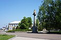 Main square of Chyhyryn
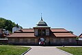 Entrance of the restored Bohdan Khmelnytskyi residence
 Bohdan Khmelnytskyi residence
 St. Peter and St. Paul Church in Chyhyryn
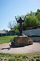 A statue near the church
 Taras Shevchenko monument in Chyhyryn
 View of Chyhyryn from the city's Castle Hill
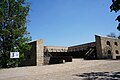 Remnants of Čyhyryn Fortress on the Castle Hill
 Bohdan Khmelnytskyi monument in Chyhyryn


International relations
Twin towns — Sister cities
Chyhyryn is twinned with:
| City | Country | Year of Signing |
|---|---|---|
| Sebastopol, California | 1993 |
References
- "Чигиринська територіальна громада" (in Ukrainian). decentralization.gov.ua.
- Чисельність наявного населення України на 1 січня 2021 [Number of Present Population of Ukraine, as of January 1, 2021] (PDF) (in Ukrainian and English). Kyiv: State Statistics Service of Ukraine.
- Всесоюзная перепись населения 1989 г. Численность городского населения союзных республик, их территориальных единиц, городских поселений и городских районов по полу
- "Про утворення та ліквідацію районів. Постанова Верховної Ради України № 807-ІХ". Голос України (in Ukrainian). 2020-07-18. Retrieved 2020-10-03.
- "Нові райони: карти + склад" (in Ukrainian). Міністерство розвитку громад та територій України.
- "World Meteorological Organization Climate Normals for 1981–2010". World Meteorological Organization. Archived from the original on 17 July 2021. Retrieved 17 July 2021.
External links
- Chyhyryn in the Encyclopedia of Ukraine
- Soviet topographic map 1:100,000
 Media related to Chyhyryn at Wikimedia Commons
Administrative center: Cherkasy | ||
| Raions | ||
| Hromadas |
| |
| Cities |
| |
| Urban-type settlements |
| |
Historical Capitals of Rus', Ukrainian states and states on Ukrainian soil1 | |||||||||
|---|---|---|---|---|---|---|---|---|---|
| Medieval and early modern Ukrainian states |
| ||||||||
| Ukrainian states after the Russian Empire and before the Ukrainian SSR |
| ||||||||
| Ukrainian SSR (since 1919), independent Ukraine (since 1991) |
| ||||||||
1Meaning (Cossack) states on the territory of current Ukraine | |||||||||
Authority control | |
|---|---|
| General |
|
| National libraries | |
| Other | |
На других языках
[de] Tschyhyryn
Tschyhyryn (ukrainisch Чигирин; russisch Чигирин .mw-parser-output .Latn{font-family:"Akzidenz Grotesk","Arial","Avant Garde Gothic","Calibri","Futura","Geneva","Gill Sans","Helvetica","Lucida Grande","Lucida Sans Unicode","Lucida Grande","Stone Sans","Tahoma","Trebuchet","Univers","Verdana"}Tschigirin, polnisch Czehryń) ist eine Kreisstadt in der ukrainischen Oblast Tscherkassy an den Ufern des Flusses Tjasmyn, welcher unterhalb der Stadt in den zum Krementschuker Stausee aufgestauten Dnepr mündet. Auf dem der Stadtverwaltung unterstellten Gebiet befindet sich neben der Stadt noch die Siedlung Tschernetsche (Чернече) mit etwa 200 Einwohnern.- [en] Chyhyryn
[es] Chihirín
Chihirín (en ucraniano: Чигирин) es una ciudad de la óblast de Cherkasy, en Ucrania central y es el centro administrativo del raión de Chyhyrýn. Situada a orillas del río Tiasmyn, está ubicada a 57 km al sudeste de Cherkasy. Su población según el recuento de 2021 es de aproximadamente 8 664 habitantes.[ru] Чигирин
Чигири́н (укр. Чигири́н) — город в Черкасской области Украины. Входит в Черкасский район; до 2020 года был административным центром упразднённого Чигиринского района.Другой контент может иметь иную лицензию. Перед использованием материалов сайта WikiSort.org внимательно изучите правила лицензирования конкретных элементов наполнения сайта.
WikiSort.org - проект по пересортировке и дополнению контента Википедии