world.wikisort.org - France
Saint-Thurien (French pronunciation: [sɛ̃ tyʁjɛ̃]; Breton: Sant-Turian) is a commune in the Finistère department of Brittany in north-western France.
Saint-Thurien
Sant-Turian | |
|---|---|
Commune | |
 The town hall in Saint-Thurien | |
Location of Saint-Thurien  | |
 Saint-Thurien  Saint-Thurien | |
| Coordinates: 47°57′36″N 3°37′21″W | |
| Country | France |
| Region | Brittany |
| Department | Finistère |
| Arrondissement | Quimper |
| Canton | Quimperlé |
| Intercommunality | Quimperlé Communauté |
| Government | |
| • Mayor (2020–2026) | Christine Kerdraon[1] |
| Area 1 | 21.41 km2 (8.27 sq mi) |
| Population | 1,038 |
| • Density | 48/km2 (130/sq mi) |
| Time zone | UTC+01:00 (CET) |
| • Summer (DST) | UTC+02:00 (CEST) |
| INSEE/Postal code | 29269 /29380 |
| Elevation | 22–166 m (72–545 ft) |
| 1 French Land Register data, which excludes lakes, ponds, glaciers > 1 km2 (0.386 sq mi or 247 acres) and river estuaries. | |
It takes its name from Saint Turiaf of Dol, bishop of the ancient Diocese of Dol.
Population
Inhabitants of Saint-Thurien are called in French Thuriennois.
|
| ||||||||||||||||||||||||||||||||||||||||||||||||||||||||||||||||||||||||||||||||||||||||||||||||||||||||||||||||||
| Source: EHESS[3] and INSEE (1968-2017)[4] | |||||||||||||||||||||||||||||||||||||||||||||||||||||||||||||||||||||||||||||||||||||||||||||||||||||||||||||||||||
Geography
Saint-Thurien is located in the southeastern part of Finistère, 11 km (6.8 mi) northwest of Quimperlé, 30 km (19 mi) northwest of Lorient and 35 km (22 mi) east of Quimper. Historically, the town belongs to Cornouaille. It lies in the valley of the river Isole. Saint-Thurien is border by Guiscriff to the north, by Querrien to the east, by Mellac to the south and by Bannalec to the west. Apart from the village centre, there are about sixty hamlets.
Map

List of places
|
|
|
|
History
The parish church was rebuilt at the end of the nineteenth century in accordance with the architect Joseph Bigot's plans. The new church replaced an older church that dated from the sixteenth century.
Economy
The Peny factory, located on the banks of the river Isole, with 340 employees, in the main employer in the town.
International relations
Since 1995, it is twinned with the village of Kilmacow in County Kilkenny, Ireland ![]() .[5]
.[5]
Gallery
 The Iron Age stele that stands in the church square
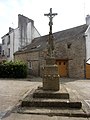 The calvary that stands in the church square
 The neo-Gothic parish church


See also
- Communes of the Finistère department
- Entry on sculptor of Saint Thurien war memorial Jean Joncourt
References
- "Répertoire national des élus: les maires". data.gouv.fr, Plateforme ouverte des données publiques françaises (in French). 9 August 2021.
- "Populations légales 2019". The National Institute of Statistics and Economic Studies. 29 December 2021.
- Des villages de Cassini aux communes d'aujourd'hui: Commune data sheet Saint-Thurien, EHESS. (in French)
- Population en historique depuis 1968, INSEE
- Kilmacow twinning at the Official Official Co. Kilkenny Web Site
External links
- Mayors of Finistère Association (in French)
Authority control | |
|---|---|
| General |
|
| National libraries | |
This Finistère geographical article is a stub. You can help Wikipedia by expanding it. |
На других языках
[de] Saint-Thurien (Finistère)
Saint-Thurien (bretonisch Sant-Turian) ist eine französische Gemeinde mit 1038 Einwohnern (Stand 1. Januar 2019) im Département Finistère in der Bretagne.- [en] Saint-Thurien, Finistère
[es] Saint-Thurien (Finisterre)
Saint-Thurien (en bretón Sant-Turian) es una población y comuna francesa, que está situada en la región de Bretaña, departamento de Finisterre, en el distrito de Quimper y cantón de Scaër.[fr] Saint-Thurien (Finistère)
Saint-Thurien [sɛ̃tyʁjɛ̃] est une commune du département du Finistère, dans la région Bretagne, en France.Другой контент может иметь иную лицензию. Перед использованием материалов сайта WikiSort.org внимательно изучите правила лицензирования конкретных элементов наполнения сайта.
WikiSort.org - проект по пересортировке и дополнению контента Википедии