world.wikisort.org - France
Locunolé (French pronunciation: [lɔkynɔle]; Breton: Lokunole) is a commune in the Finistère department of Brittany in north-western France.
Locunolé
Lokunole | |
|---|---|
Commune | |
 The church of Saint-Guénolé | |
Location of Locunolé  | |
 Locunolé  Locunolé | |
| Coordinates: 47°56′13″N 3°28′38″W | |
| Country | France |
| Region | Brittany |
| Department | Finistère |
| Arrondissement | Quimper |
| Canton | Quimperlé |
| Intercommunality | Quimperlé Communauté |
| Government | |
| • Mayor (2020–2026) | Corinne Collet[1] |
| Area 1 | 16.78 km2 (6.48 sq mi) |
| Population | 1,158 |
| • Density | 69/km2 (180/sq mi) |
| Time zone | UTC+01:00 (CET) |
| • Summer (DST) | UTC+02:00 (CEST) |
| INSEE/Postal code | 29136 /29310 |
| Elevation | 12–121 m (39–397 ft) |
| 1 French Land Register data, which excludes lakes, ponds, glaciers > 1 km2 (0.386 sq mi or 247 acres) and river estuaries. | |
Toponymy
From the Breton loc which means hermitage and 'unolé' which derive from Saint Guénolé.
Geography
The village centre is located 9 km (5.6 mi) north-east of Quimperlé. The river Ellé forms the eastern border of the commune.
Neighbouring communes
Locunolé is border by Guilligomarc'h to east, by Arzano to south, by Tréméven to west and by Querrien to north.
Places adjacent to Locunolé | ||||||||||||||||
|---|---|---|---|---|---|---|---|---|---|---|---|---|---|---|---|---|
| ||||||||||||||||
Population
Inhabitants of Locunolé are called in French Locunolois.
|
| |||||||||||||||||||||||||||||||||||||||||||||||||||||||||||||||||||||||||||||||||||||||||||||||||||||||||||||||
| Source: EHESS[3] and INSEE (1968-2017)[4] | ||||||||||||||||||||||||||||||||||||||||||||||||||||||||||||||||||||||||||||||||||||||||||||||||||||||||||||||||
Map

Gallery
 The parish church Saint Guénolé
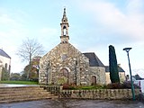 Chapel Notre Dame de Folgoët
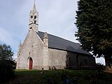 Chapel Sainte-Gertrude
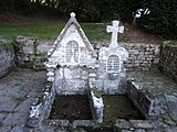 Fountains of saints
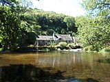 Mill Mohot


See also
- Communes of the Finistère department
- Entry on sculptor of local war memorial Jean Joncourt
References
- "Répertoire national des élus: les maires". data.gouv.fr, Plateforme ouverte des données publiques françaises (in French). 9 August 2021.
- "Populations légales 2019". The National Institute of Statistics and Economic Studies. 29 December 2021.
- Des villages de Cassini aux communes d'aujourd'hui: Commune data sheet Locunolé, EHESS. (in French)
- Population en historique depuis 1968, INSEE
External links
Wikimedia Commons has media related to Locunolé.
- Mayors of Finistère Association (in French)
This Finistère geographical article is a stub. You can help Wikipedia by expanding it. |
На других языках
[de] Locunolé
Locunolé (bretonisch Loculone) ist eine französische Gemeinde in der Region Bretagne im Département Finistère mit 1.158 Einwohnern (Stand 1. Januar 2019).- [en] Locunolé
[fr] Locunolé
Locunolé [lokynole] est une commune du département du Finistère, dans la région Bretagne, en France. Locunolé est surtout réputée pour le site spectaculaire des Roches du Diable, dont le bassin d'eau vive est situé près du bourg de Locunolé, entre les communes de Guilligomarc'h et Querrien. La rivière Ellé s'y faufile entre d'énormes rochers en granite polis par l'érosion. Ce site de grande renommée accueille régulièrement des compétitions de canoë-kayak de catégories nationales et internationales.Текст в блоке "Читать" взят с сайта "Википедия" и доступен по лицензии Creative Commons Attribution-ShareAlike; в отдельных случаях могут действовать дополнительные условия.
Другой контент может иметь иную лицензию. Перед использованием материалов сайта WikiSort.org внимательно изучите правила лицензирования конкретных элементов наполнения сайта.
Другой контент может иметь иную лицензию. Перед использованием материалов сайта WikiSort.org внимательно изучите правила лицензирования конкретных элементов наполнения сайта.
2019-2026
WikiSort.org - проект по пересортировке и дополнению контента Википедии
WikiSort.org - проект по пересортировке и дополнению контента Википедии