world.wikisort.org - France
Quimperlé (French pronunciation: [kɛ̃pɛʁle]; Breton: Kemperle) is a commune in the Finistère department of Brittany in northwestern France.
Quimperlé
Kemperle | |
|---|---|
Commune | |
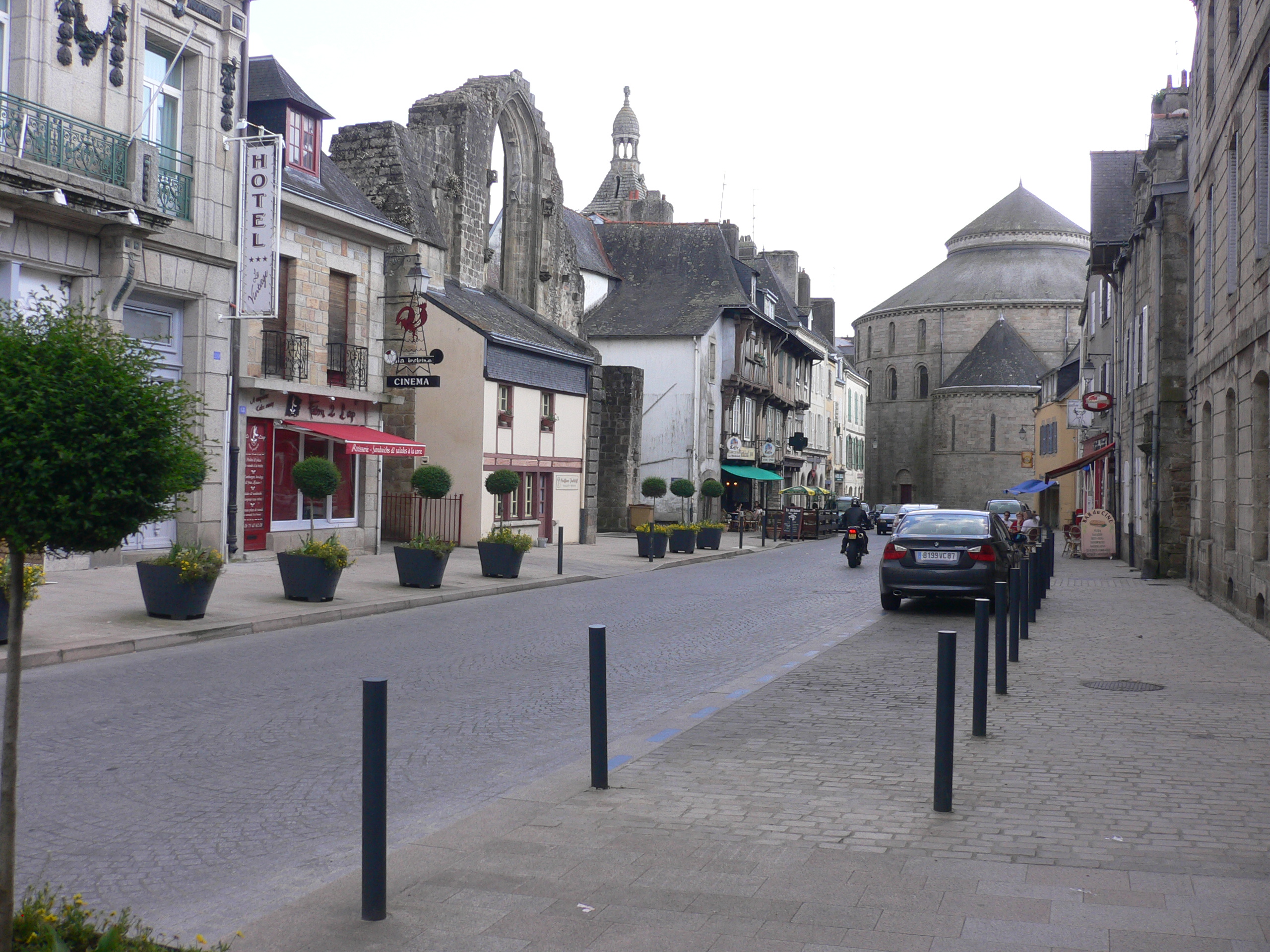 Brémond d'Ars street | |
 Coat of arms | |
Location of Quimperlé  | |
 Quimperlé  Quimperlé | |
| Coordinates: 47°52′25″N 3°32′55″W | |
| Country | France |
| Region | Brittany |
| Department | Finistère |
| Arrondissement | Quimper |
| Canton | Quimperlé |
| Intercommunality | Quimperlé Communauté |
| Government | |
| • Mayor (2020–2026) | Michaël Qernez |
| Area 1 | 31.73 km2 (12.25 sq mi) |
| Population | 12,220 |
| • Density | 390/km2 (1,000/sq mi) |
| Time zone | UTC+01:00 (CET) |
| • Summer (DST) | UTC+02:00 (CEST) |
| INSEE/Postal code | 29233 /29300 |
| Elevation | 2–83 m (6.6–272.3 ft) |
| 1 French Land Register data, which excludes lakes, ponds, glaciers > 1 km2 (0.386 sq mi or 247 acres) and river estuaries. | |
Geography
Quimperlé is in the southeast of Finistère, 20 km to the west of Lorient and 44 km to the east of Quimper. Historically, it belongs to Cornouaille. The town is situated at the confluence of the Isole and Ellé rivers that combine to form the Laïta river, hence its name: confluent (kemper-) of the Ellé (-le). A fourth smaller river, the Dourdu (black water in Breton), joins the Laïta downstream. Quimperlé station has rail connections to Quimper, Lorient, Vannes and Rennes.
The city is traditionally divided in two parts, the High Town and the Lower Town. The Lower Town, in the valley, is the historical centre, and developed around the Saint-Colomban church (of which only the front wall remains) and the abbey of Sainte Croix (Holy Cross). It covers the land between the Ellé and Isole rivers as well as the banks of the Laïta, an area that is sometimes flooded.
The more modern High Town, in the plain above the valley, centres around the Saint-Michel church and its market square. Seen from the Lower Town, its "mountain" topped with the Saint-Michel church has earned Quimperlé the nickname of "Mount Saint Michel on land"
The town also developed, less importantly, on the East side of the valley, facing the Saint Michel mountain. This area is called Bourgneuf, a common name for recent neighbourhoods.

Map

Population
Inhabitants of Quimperlé are called in French Quimperlois.
|
| ||||||||||||||||||||||||||||||||||||||||||||||||||||||||||||||||||||||||||||||||||||||||||||||||||||||||||||||||||
| Source: EHESS[2] and INSEE (1968-2017)[3] | |||||||||||||||||||||||||||||||||||||||||||||||||||||||||||||||||||||||||||||||||||||||||||||||||||||||||||||||||||
History
It seems that the area was first inhabited by Neanderthals, since remains of Mousterian-style stone tools have been found in the forest between Quimperlé and Clohars-Carnoët. A few dolmens were erected in Quimperlé itself, although there is no trace of an actual settlement in the prehistoric times.
A first settlement was built in the Middle Ages, called Villa Anaurot, after a 5th-century British prince, but it is thought to have been destroyed by the Normans in 868.
A new town called Quimperlé grew around the abbey of Sainte Croix, which was founded in the 12th century. The Romanesque basilica from the abbey can still be seen. The church of St Michel was built in the 14th and 15th centuries and its impressive tower dominates the town from its hilltop position.
Breton language
- The municipality launched a linguistic plan concerning the Breton language through Ya d'ar brezhoneg on December 18, 2008.
- In 2008, 3.17% of primary-school children attended bilingual schools.[4]
Gallery
Old houses
 Old house called Ty Coz in place Saint Michel
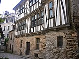 Timbered house called Maison des archers
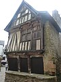 Timbered house in Street Dom Maurice


See also
- Communes of the Finistère department
- Entry on sculptor Jean Joncourt who lived in Quimperlé
- List of works of the two Folgoët ateliers
- Henri Alphonse Barnoin
References
- "Populations légales 2019". The National Institute of Statistics and Economic Studies. 29 December 2021.
- Des villages de Cassini aux communes d'aujourd'hui: Commune data sheet Quimperlé, EHESS. (in French)
- Population en historique depuis 1968, INSEE
- (in French) Ofis ar Brezhoneg: Enseignement bilingue
External links
- Town council website (in French)
- Tourist office website (in French)
- Cultural Heritage (in French)
Authority control | |
|---|---|
| General | |
| National libraries | |
| Other | |
На других языках
[de] Quimperlé
Quimperlé (bret. Kemperle) ist eine Stadt mit 12.220 Einwohnern (Stand 1. Januar 2019) im Nordwesten Frankreichs. Quimperlé liegt in der Region Bretagne, Département Finistère in der Cornouaille. Der bretonische Name Kemperle leitet sich von Kemper Ele (dt. Zusammenfluss der Ele) ab, da hier die Isole (bret. Izol) in die Ellé (bret. Ele) fließt, die ab hier den Ästuar namens Laïta bildet und schließlich in den Atlantik mündet.- [en] Quimperlé
[fr] Quimperlé
Quimperlé [kɛ̃pɛʁle] est une commune française, située dans le département du Finistère en région Bretagne.[ru] Кемперле
Кемперле (фр. Quimperlé, брет. Kemperle) — город на северо-западе Франции, находится в регионе Бретань, департамент Финистер, округ Кемпер, центр одноименного кантона. Расположен в 47 км к востоку от Кемпера и в 74 км к западу от Ванна, в месте слияния рек Элле и Изоль, образующих реку Лаита. Через территорию коммуны проходит национальная автомагистраль N165. В центре города находится железнодорожная станция Кемперле линии Савене-Ландерно.Другой контент может иметь иную лицензию. Перед использованием материалов сайта WikiSort.org внимательно изучите правила лицензирования конкретных элементов наполнения сайта.
WikiSort.org - проект по пересортировке и дополнению контента Википедии