world.wikisort.org - France
Mellac (French pronunciation: [mɛlak]; Breton: Mellag) is a commune in the Finistère department of Brittany in north-western France.
Mellac
Mellag | |
|---|---|
Commune | |
 The town hall in Mellac | |
 Coat of arms | |
Location of Mellac  | |
 Mellac  Mellac | |
| Coordinates: 47°54′17″N 3°34′36″W | |
| Country | France |
| Region | Brittany |
| Department | Finistère |
| Arrondissement | Quimper |
| Canton | Quimperlé |
| Intercommunality | Quimperlé Communauté |
| Government | |
| • Mayor (2020–2026) | Franck Chapoulie[1] |
| Area 1 | 26.38 km2 (10.19 sq mi) |
| Population | 3,242 |
| • Density | 120/km2 (320/sq mi) |
| Time zone | UTC+01:00 (CET) |
| • Summer (DST) | UTC+02:00 (CEST) |
| INSEE/Postal code | 29147 /29300 |
| Elevation | 12–101 m (39–331 ft) |
| 1 French Land Register data, which excludes lakes, ponds, glaciers > 1 km2 (0.386 sq mi or 247 acres) and river estuaries. | |
Population
Inhabitants of Mellac are called in French Mellacois.
|
|
| |||||||||||||||||||||||||||||||||||||||||||||||||||||||||||||||||||||||||||||||||||||||||||||||||||||||||||||||||||||
| Source: EHESS[3] and INSEE (1968-2019)[4] | |||||||||||||||||||||||||||||||||||||||||||||||||||||||||||||||||||||||||||||||||||||||||||||||||||||||||||||||||||||||
Geography
The village centre is located 4.5 km (2.8 mi) northeast of Quimperlé. Historically, Mellac belongs to Cornouaille. The river Isole forms the commune's northern and eastern borders.
Neighboring communes
Mellac is border by Saint-Thurien and Querrien to the north, by Tréméven to the east, by Quimperlé and Baye to the south and by Le Trévoux and Bannalec to the west.
Map

History
The oldest surviving parish registers date back to 1562.

Gallery
 Manor of Kernault
 Granary of Manor of Kernault
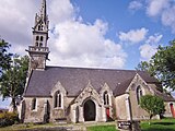 The parish church


See also
References
- "Répertoire national des élus: les maires". data.gouv.fr, Plateforme ouverte des données publiques françaises (in French). 9 August 2021.
- "Populations légales 2019". The National Institute of Statistics and Economic Studies. 29 December 2021.
- Des villages de Cassini aux communes d'aujourd'hui: Commune data sheet Mellac, EHESS. (in French)
- , INSEE
- Mayors of Finistère Association (in French);
External links
Wikimedia Commons has media related to Mellac.
- Cultural Heritage (in French)
Authority control | |
|---|---|
| General |
|
| National libraries | |
This Finistère geographical article is a stub. You can help Wikipedia by expanding it. |
На других языках
[de] Mellac
Mellac (bretonisch Mellag) ist eine französische Gemeinde mit 3242 Einwohnern (Stand 1. Januar 2019) im Département Finistère.- [en] Mellac
[fr] Mellac
Mellac [mɛlak] est une commune du département du Finistère, dans la région Bretagne, en France.Текст в блоке "Читать" взят с сайта "Википедия" и доступен по лицензии Creative Commons Attribution-ShareAlike; в отдельных случаях могут действовать дополнительные условия.
Другой контент может иметь иную лицензию. Перед использованием материалов сайта WikiSort.org внимательно изучите правила лицензирования конкретных элементов наполнения сайта.
Другой контент может иметь иную лицензию. Перед использованием материалов сайта WikiSort.org внимательно изучите правила лицензирования конкретных элементов наполнения сайта.
2019-2026
WikiSort.org - проект по пересортировке и дополнению контента Википедии
WikiSort.org - проект по пересортировке и дополнению контента Википедии