world.wikisort.org - France
Plouhinec (French pronunciation: [pluinɛk]; Breton: Ploeneg) is a commune in the Finistère department of Brittany in north-western France.
Plouhinec
Ploeneg | |
|---|---|
Commune | |
 Bay of Pors Poulhan - Harbour of Plouhinec | |
 Coat of arms | |
Location of Plouhinec  | |
 Plouhinec  Plouhinec | |
| Coordinates: 48°00′51″N 4°29′11″W | |
| Country | France |
| Region | Brittany |
| Department | Finistère |
| Arrondissement | Quimper |
| Canton | Douarnenez |
| Intercommunality | Cap Sizun - Pointe du Raz |
| Government | |
| • Mayor (2020–2026) | Yvan Moullec |
| Area 1 | 28.05 km2 (10.83 sq mi) |
| Population | 3,951 |
| • Density | 140/km2 (360/sq mi) |
| Time zone | UTC+01:00 (CET) |
| • Summer (DST) | UTC+02:00 (CEST) |
| INSEE/Postal code | 29197 /29780 |
| Elevation | 0–104 m (0–341 ft) |
| 1 French Land Register data, which excludes lakes, ponds, glaciers > 1 km2 (0.386 sq mi or 247 acres) and river estuaries. | |
The commune lies on the road from Pont-l'Abbé to Audierne.
Landmarks in the town include the Saint-Winoc Church, which dates from the sixteenth century, and the scenic, small natural port of the borough of Pors-Poulhan. Its smooth white-sand beaches with their light surf are ideal for families with children.
The village contains sculptures by locally born artist René Quillivic.
Population
|
| ||||||||||||||||||||||||||||||||||||||||||||||||||||||||||||||||||||||||||||||||||||||||||||||||||||||||||||||||||
| Source: EHESS[2] and INSEE (1968-2017)[3] | |||||||||||||||||||||||||||||||||||||||||||||||||||||||||||||||||||||||||||||||||||||||||||||||||||||||||||||||||||
Gallery
 Sunset on the Plouhinec beach.
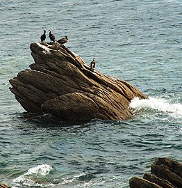 Cormorants at the Harbour of Pors-Poulhan.


See also
References
- "Populations légales 2019". The National Institute of Statistics and Economic Studies. 29 December 2021.
- Des villages de Cassini aux communes d'aujourd'hui: Commune data sheet Plouhinec, EHESS. (in French)
- Population en historique depuis 1968, INSEE
- The information in this article is based on a translation of its German equivalent.
External links
Wikimedia Commons has media related to Plouhinec, Finistère.
- Official website (in French)
- Base Mérimée: Search for heritage in the commune, Ministère français de la Culture. (in French)
- Mayors of Finistère Association (in French)
Authority control | |
|---|---|
| General |
|
| National libraries | |
| Other |
|
This Finistère geographical article is a stub. You can help Wikipedia by expanding it. |
На других языках
[de] Plouhinec (Finistère)
Vorlage:Infobox Gemeinde in Frankreich/Wartung/abweichendes Wappen in Wikidata- [en] Plouhinec, Finistère
[ru] Плуинек (Финистер)
Плуинек (фр. Plouhinec) — коммуна на северо-западе Франции, находится в регионе Бретань, департамент Финистер, округ Кемпер, кантон Дуарнене. Расположена в 87 км к югу от Бреста и в 30 км к западу от Кемпера, на побережье бухты Одьерн Атлантического океана.Текст в блоке "Читать" взят с сайта "Википедия" и доступен по лицензии Creative Commons Attribution-ShareAlike; в отдельных случаях могут действовать дополнительные условия.
Другой контент может иметь иную лицензию. Перед использованием материалов сайта WikiSort.org внимательно изучите правила лицензирования конкретных элементов наполнения сайта.
Другой контент может иметь иную лицензию. Перед использованием материалов сайта WikiSort.org внимательно изучите правила лицензирования конкретных элементов наполнения сайта.
2019-2025
WikiSort.org - проект по пересортировке и дополнению контента Википедии
WikiSort.org - проект по пересортировке и дополнению контента Википедии