world.wikisort.org - France
Pont-l'Abbé (French pronunciation: [pɔ̃ labe]; Breton: Pont-'n-Abad, "Abbot's bridge") is a commune in the Finistère department of Brittany in north-western France.
Pont-l'Abbé
Pont-'n-Abad | |
|---|---|
Commune | |
 The harbour of Pont-l'Abbé | |
 Flag  Coat of arms | |
| Motto: Heb Ken | |
Location of Pont-l'Abbé  | |
 Pont-l'Abbé  Pont-l'Abbé | |
| Coordinates: 47°52′05″N 4°13′19″W | |
| Country | France |
| Region | Brittany |
| Department | Finistère |
| Arrondissement | Quimper |
| Canton | Pont-l'Abbé |
| Intercommunality | Pays Bigouden Sud |
| Government | |
| • Mayor (2020–2026) | Stéphane Le Doaré[1] |
| Area 1 | 18.21 km2 (7.03 sq mi) |
| Population | 8,369 |
| • Density | 460/km2 (1,200/sq mi) |
| Time zone | UTC+01:00 (CET) |
| • Summer (DST) | UTC+02:00 (CEST) |
| INSEE/Postal code | 29220 /29120 |
| Elevation | 0–37 m (0–121 ft) |
| 1 French Land Register data, which excludes lakes, ponds, glaciers > 1 km2 (0.386 sq mi or 247 acres) and river estuaries. | |
The self-styled capital of Pays Bigouden (roughly the region between the river Odet and the Bay of Audierne), Pont-l'Abbé was founded in the 14th century by a monk of Loctudy who built the first bridge across the river estuary, hence the name. The same monk also built the first castle.
Geography
Climate
Pont-l'Abbé has a oceanic climate (Köppen climate classification Cfb). The average annual temperature in Pont-l'Abbé is 12.8 °C (55.0 °F). The average annual rainfall is 993.3 mm (39.11 in) with November as the wettest month. The temperatures are highest on average in August, at around 18.7 °C (65.7 °F), and lowest in January, at around 7.5 °C (45.5 °F). The highest temperature ever recorded in Pont-l'Abbé was 37.1 °C (98.8 °F) on 16 July 2006; the coldest temperature ever recorded was −10.8 °C (12.6 °F) on 2 January 1997.
| Climate data for Pont-l'Abbé (1981–2010 averages, extremes 1994−2020) | |||||||||||||
|---|---|---|---|---|---|---|---|---|---|---|---|---|---|
| Month | Jan | Feb | Mar | Apr | May | Jun | Jul | Aug | Sep | Oct | Nov | Dec | Year |
| Record high °C (°F) | 16.7 (62.1) |
18.6 (65.5) |
22.5 (72.5) |
28.0 (82.4) |
31.4 (88.5) |
35.4 (95.7) |
37.1 (98.8) |
36.6 (97.9) |
32.3 (90.1) |
28.1 (82.6) |
21.5 (70.7) |
19.1 (66.4) |
37.1 (98.8) |
| Average high °C (°F) | 10.9 (51.6) |
11.8 (53.2) |
13.8 (56.8) |
16.1 (61.0) |
19.3 (66.7) |
22.2 (72.0) |
23.4 (74.1) |
24.1 (75.4) |
21.9 (71.4) |
18.1 (64.6) |
14.2 (57.6) |
11.2 (52.2) |
17.3 (63.1) |
| Daily mean °C (°F) | 7.5 (45.5) |
8.0 (46.4) |
9.4 (48.9) |
11.2 (52.2) |
14.3 (57.7) |
17.0 (62.6) |
18.5 (65.3) |
18.7 (65.7) |
16.6 (61.9) |
14.0 (57.2) |
10.5 (50.9) |
7.8 (46.0) |
12.8 (55.0) |
| Average low °C (°F) | 4.1 (39.4) |
4.2 (39.6) |
5.0 (41.0) |
6.2 (43.2) |
9.4 (48.9) |
11.8 (53.2) |
13.5 (56.3) |
13.3 (55.9) |
11.3 (52.3) |
10.0 (50.0) |
6.8 (44.2) |
4.4 (39.9) |
8.4 (47.1) |
| Record low °C (°F) | −10.8 (12.6) |
−6.6 (20.1) |
−7.0 (19.4) |
−1.6 (29.1) |
0.3 (32.5) |
4.1 (39.4) |
6.5 (43.7) |
6.1 (43.0) |
3.2 (37.8) |
−1.6 (29.1) |
−3.7 (25.3) |
−7.7 (18.1) |
−10.8 (12.6) |
| Average precipitation mm (inches) | 114.8 (4.52) |
92.7 (3.65) |
72.4 (2.85) |
78.1 (3.07) |
69.3 (2.73) |
43.3 (1.70) |
53.1 (2.09) |
59.1 (2.33) |
62.3 (2.45) |
103.4 (4.07) |
126.2 (4.97) |
118.6 (4.67) |
993.3 (39.11) |
| Average precipitation days (≥ 1.0 mm) | 14.8 | 12.1 | 11.9 | 11.2 | 9.9 | 6.8 | 9.4 | 8.2 | 8.7 | 14.0 | 16.4 | 15.5 | 138.9 |
| Source: Meteociel[3] | |||||||||||||
Population
Inhabitants of Pont-l'Abbé are called in French Pont-l'Abbistes.
|
|
| |||||||||||||||||||||||||||||||||||||||||||||||||||||||||||||||||||||||||||||||||||||||||||||||||||||||||||||||||||||
| Source: EHESS[4] and INSEE (1968-2017)[5] | |||||||||||||||||||||||||||||||||||||||||||||||||||||||||||||||||||||||||||||||||||||||||||||||||||||||||||||||||||||||
Breton language
The municipality launched a linguistic plan concerning the Breton language through Ya d'ar brezhoneg on February 2, 2008.
In 2008, 5.08% of primary-school children attended bilingual schools.[6]
The Fête des Brodeuses (Embroideress' Festival) in July is one of Brittany's major traditional gatherings, and includes a Breton Mass at the Notre-Dame des Carmes church.
Sights
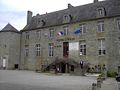
- Pont-l'Abbé castle dates from the 14th to the 18th centuries. The "wedding" room is decorated with Mathurin Méheut pieces of art (Sainte-Marine port), Henri Sollier and Jacques Godin. Once bigger, the castle lost its ramparts during the 19th century. Today only the bridge, the keep, and a very small part of the ramparts, in the garden nearby, can be seen. The structure now serves as the city hall, housing also the Bigouden Museum, offering a fine collection of costumes and Bigouden head-dresses,
- Church of Notre-Dame des Carmes dates from 1383-1420 in the Gothic style, with many old statues and a very fine rose window over the high altar that is considered the loveliest in Brittany.
- Church of Lambour (13th-16th century) had its roof removed in 1675 in the reign of Louis XIV in reprisal against the "Red Bonnets" uprising.
- The Monument aux Bigoudens is a masterpiece in granite by François Bazin (1931) and shows a group of four Bigoudène women and a child in traditional costume from the beginning of the 20th century, all of them thinking of a son, a father, a husband or a grandson battling the elements on the high seas.
- The Manoir de Kernuz was restored c. 1850 by the historian of Brittany, Armand du Chatellier.
- The Manoir de Kerazan located between Pont-l'Abbé and Loktudi delivers a fine art of Architecture.
- The Chapel of Treminoù (the missings in Breton) on the road to St-Jean-Trolimon, celebrates the memory of the Breton insurgents slaughtered by the French army of Louis XIV. In particular, A gathering in the last week of September and a funfair festival in the City recalls this period of Brittany's history.
- A few Menhirs still island upright around the city.
- Down to the river by the sea, lies a ria, having given its name to Loktudi (Loch Tudi, the lagoon of Saint Tudi) and Isle Tudi, which shares some beautiful sights.
 Present view of the Castle's keep, south view.
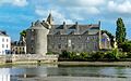 the Castle's keep, north view.
 the Castle's keep, from Rue Kereon, 1921.


International relations
Pont-l'Abbé is twinned with:
Personalities
- Vincent Riou, a yacht race Sailor who distinguished himself at Vendée Globe Challenge 2004-2005 (1st) and 2008-2009 (3rd) with act of bravery, saving Jean Le Cam's life, who was sinking near of Cape Horn.
- Jérôme Kerviel, the trader formerly with Société Générale in Paris that was linked with losses of approximately €4.9 billion (US$7.16 billion) stemming from fraudulent equity index futures trading, grew up in Pont-l'Abbé.
See also
References
- "Répertoire national des élus: les maires". data.gouv.fr, Plateforme ouverte des données publiques françaises (in French). 9 August 2021.
- "Populations légales 2019". The National Institute of Statistics and Economic Studies. 29 December 2021.
- "Normales et records pour Pont-l'Abbe (29)". Meteociel. Retrieved 10 June 2022.
- Des villages de Cassini aux communes d'aujourd'hui: Commune data sheet Pont-l'Abbé, EHESS. (in French)
- Population en historique depuis 1968, INSEE
- (in French) Ofis ar Brezhoneg: Enseignement bilingue
External links
- Official website (in French)
- Official Pont-l'Abbé Tourism site
- Bigouden Museum of Pont-l'Abbé (in French)
- Ar Triskell, Cultures' House of Pont-l'Abbé (in French)
- Base Mérimée: Search for heritage in the commune, Ministère français de la Culture. (in French)
- Mayors of Finistère Association (in French)
Authority control | |
|---|---|
| General |
|
| National libraries | |
| Other |
|
На других языках
[de] Pont-l’Abbé
Pont-l’Abbé (bretonisch Pont-’n-Abad) ist eine Gemeinde in der Cornouaille, im Westen Frankreichs im Département Finistère in der Region Bretagne. Auf einer Fläche von 18,21 km² leben 8369 Einwohner (Stand 1. Januar 2019).- [en] Pont-l'Abbé
[ru] Пон-л’Аббе
Пон-л’Аббе (фр. Pont-l’Abbé, брет. Pont-'n-Abad) — коммуна на северо-западе Франции, находится в регионе Бретань, департамент Финистер, округ Кемпер, центр кантона Пон-л’Аббе. Центр исторической области Земля Бигуден, расположена в крайней юго-западной части полуострова Бретань, в 19 км к юго-западу от Кемпера, на побережье большого риа Бискайского залива (фр. Rivière de Pont-l'Abbé).Другой контент может иметь иную лицензию. Перед использованием материалов сайта WikiSort.org внимательно изучите правила лицензирования конкретных элементов наполнения сайта.
WikiSort.org - проект по пересортировке и дополнению контента Википедии