world.wikisort.org - France
Arrien (French pronunciation: [aʁjɛ̃]; Occitan: Arrien) is a commune in the Pyrénées-Atlantiques department in the Nouvelle-Aquitaine region of south-western France.
Arrien | |
|---|---|
Commune | |
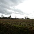
 Countryside at Arrien | |
Location of Arrien  | |
 Arrien  Arrien | |
| Coordinates: 43°18′41″N 0°09′15″W | |
| Country | France |
| Region | Nouvelle-Aquitaine |
| Department | Pyrénées-Atlantiques |
| Arrondissement | Pau |
| Canton | Pays de Morlaàs et du Montanérès |
| Intercommunality | CC Nord-Est Béarn |
| Government | |
| • Mayor (2020–2026) | Jean Canton[1] |
| Area 1 | 4.46 km2 (1.72 sq mi) |
| Population | 190 |
| • Density | 43/km2 (110/sq mi) |
| Time zone | UTC+01:00 (CET) |
| • Summer (DST) | UTC+02:00 (CEST) |
| INSEE/Postal code | 64053 /64420 |
| Elevation | 312–389 m (1,024–1,276 ft) (avg. 374 m or 1,227 ft) |
| 1 French Land Register data, which excludes lakes, ponds, glaciers > 1 km2 (0.386 sq mi or 247 acres) and river estuaries. | |
Geography
Arrien is located some 18 km east by north-east of Pau and 5 km west of Séron. Access to the commune is by road D42 from Sedzère in the north passing through the heart of the commune east of the village and continuing south to Eslourenties-Daban. The D145 also comes from Baleix in the north and joins the D42 in the commune then continues south-west to Lourenties. Access to the village (Town Hall) is by the Chemin de l'Eglise going west from the D42 and by other local roads. Apart from some patches of forest on the western border the commune is entirely farmland.[3]
The Canne stream forms the southern border of the commune joining the Gabas at the south-western corner which in turn forms most of the western border of the commune flowing north-west then north eventually joining the Adour near Toulouzette. The Poundets stream forms the eastern border of the commune and flows north to join the Petit Lees near Lombia.
Places and Hamlets
- Canton
- Cazaux
- Claria
- La Croix d'Arrien
- Fontaine Saint-Jean
- Peret
- La Picharotte
- Poulot
- Pouygarou
- Sarthou
Neighbouring communes and villages
Places adjacent to Arrien | |
|---|---|
Toponymy
Its name in béarnais is Arrien.
Michel Grosclaude indicated that the origin of the name is obscure and mentioned the possibility of the name of a former owner Ariee.[4]
The following table details the origins of the commune name.
| Name | Spelling | Date | Source | Page | Origin | Description |
|---|---|---|---|---|---|---|
| Arrien | Arien | 1385 | Raymond | 12 | Census | Village |
| Rien | 1536 | Raymond | 12 | Eslourenties | ||
| Saint-Jean d'Arien | 18th century | Raymond | 12 | Empire | ||
| Arrien | 1750 | Cassini | ||||
| Arricu | 1793 | Ldh/EHESS/Cassini |
Sources:
- Raymond: Topographic Dictionary of the Department of Basses-Pyrenees, 1863, on the page numbers indicated in the table. (in French)[5]
- Cassini: Cassini Map from 1750[6]
- Ldh/EHESS/Cassini: Des villages de Cassini aux communes d'aujourd'hui: Commune data sheet Arrien, EHESS. (in French)
Origins:
- Census: Census of Béarn[7]
- Eslourenties: Census of Eslourenties[8]
- Empire: Archives of the Empire, K 779, No. 12 (in French)
History
Paul Raymond noted that the commune had a Lay Abbey, vassal of the Viscounts of Béarn. In 1385 Arrien had 5 fires and depended on the bailiwick of Pau. The church depended on the Abbey of Saint-Sigismund at Orthez.[5]
The Saint-Jean fountain is known for its healing powers of varicose ulcers and eye diseases and has attracted many pilgrims since the 12th century.[9]
The commune was part of the Archdeaconry of Vic-Bilh, which depended on the Bishop of Lescar. Lembeye was the chief town.[10]
Administration
This list is incomplete; you can help by adding missing items. (April 2021) |
List of Successive Mayors[11]
| From | To | Name |
|---|---|---|
| 1923 | 1929 | Dominique Pédedieu |
| 1929 | 1944 | Joseph Canton |
| 1944 | 1946 | Joseph Lahon |
| 1947 | 1959 | Joseph Canton |
| 1959 | 1983 | Pierre Canton |
| 1983 | 1995 | André Cazalis |
| 1995 | 2001 | Jean Canton |
| 2001 | 2005 | Jean Louis Cazalis |
| 2005 | 2008 | Bernard Joan |
| 2008 | 2020 | Martine Loustau |
| 2020 | 2026 | Jean Canton |
Inter-communality
The commune is part of four inter-communal structures:
- the Communauté de communes du Nord-Est Béarn;
- the AEP association of Luy and Gabas;
- the Energy association of Pyrénées-Atlantiques;
- the inter-communal association for the construction of the Soumoulou rescue centre;
Demography
In 2017 the commune had 185 inhabitants.
|
| ||||||||||||||||||||||||||||||||||||||||||||||||||||||||||||||||||||||||||||||||||||||||||||||||||||||||||||||||||
| Source: EHESS[12] and INSEE[13] | |||||||||||||||||||||||||||||||||||||||||||||||||||||||||||||||||||||||||||||||||||||||||||||||||||||||||||||||||||
Culture and Heritage
Civil Heritage
There are two registrations of historical monuments for Arrien:
- Houses and Farms
 [14]
[14] - The former Chateau of Arrien (19th century)..[15] The original chateau was sold in 1730 and converted to a presbytery. The building was sold by the commune in 1975. It is shown on the Cassini Map as a "chateau".
Religious Heritage
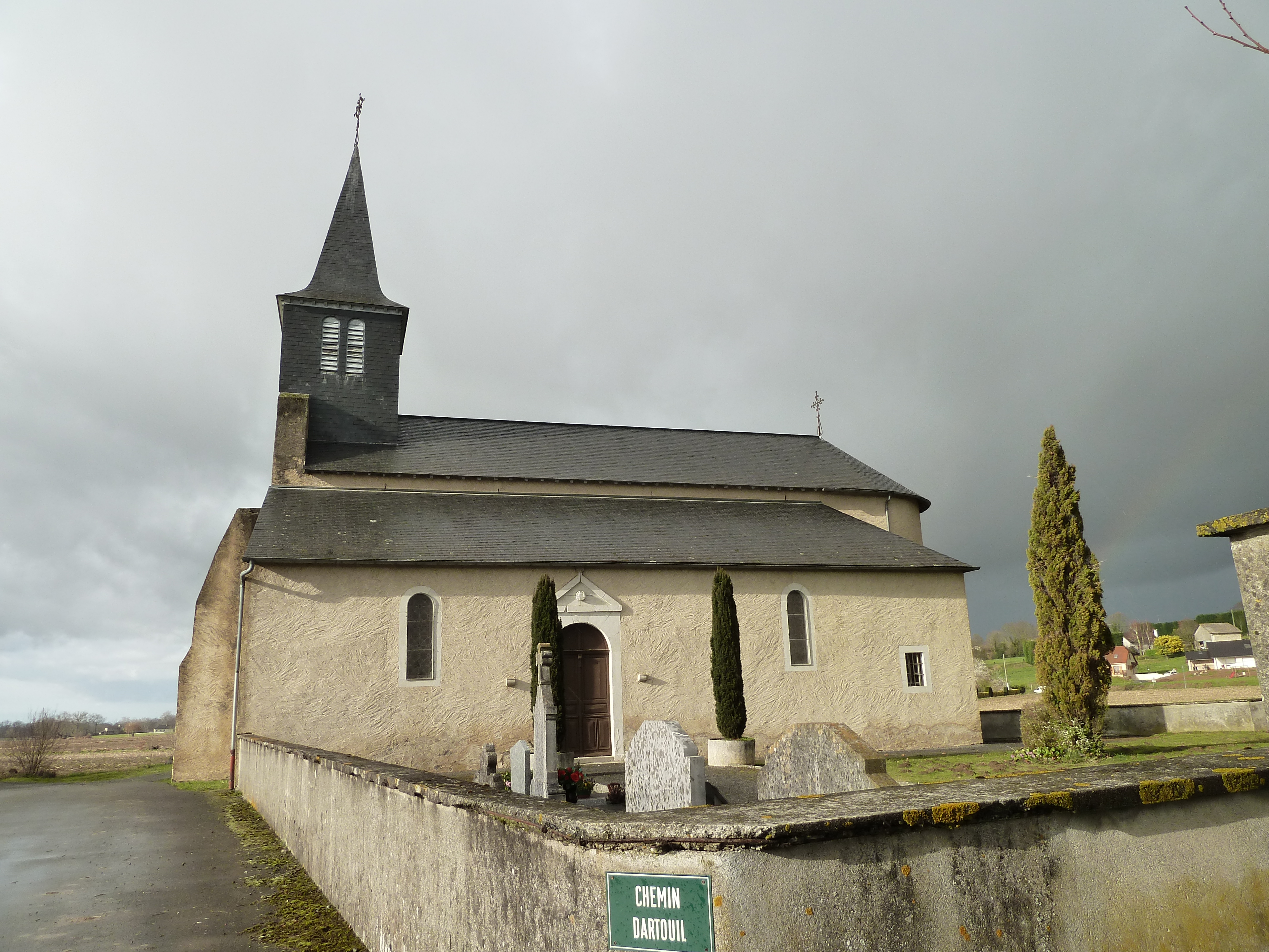
The Parish Church of Saint John the Baptist (19th century)![]() is registered as an historical monument.[16] The church contains several items that are registered as historical objects:
is registered as an historical monument.[16] The church contains several items that are registered as historical objects:
- The Furniture in the Church
 [17]
[17] - A Sunburst Monstrance (19th century)[18]
- A Processional Cross (17th century)[19]
- A Processional banner (19th century)[20]
- Church Picture Gallery
 The Church over the fields
 The Church from the road
 The church through the trees
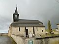 The church


See also
References
- "Répertoire national des élus: les maires". data.gouv.fr, Plateforme ouverte des données publiques françaises (in French). 2 December 2020.
- "Populations légales 2019". The National Institute of Statistics and Economic Studies. 29 December 2021.
- Google Maps
- Michel Grosclaude, Toponymic Dictionary of communes, Béarn, Edicions reclams & Édition Cairn - 2006, 416 pages, ISBN 2 35068 005 3 (in French)
- Topographic Dictionary of the Department of Basses-Pyrenees, Paul Raymond, Imprimerie nationale, 1863, Digitised from Lyon Public Library 15 June 2011 (in French)
- Cassini Map 1750 – Arrien
- Manuscript from the 14th century - Departmental Archives of Pyrénées-Atlantiques (in French)
- Census of Eslourenties, B. 807, f° 17 (in French)
- Brigitte Jobbé-Duval, Dictionary of place names - Pyrénées-Atlantiques, 2009, Archives and Culture, ISBN 978-2-35077-151-9 (in French)
- Topographic Dictionary of the Department of Basses-Pyrenees, Paul Raymond, Imprimerie nationale, 1863, Digitised from Lyon Public Library 15 June 2011, p. 174 (in French)
- List of Mayors of France (in French)
- Des villages de Cassini aux communes d'aujourd'hui: Commune data sheet Arrien, EHESS. (in French)
- Population en historique depuis 1968, INSEE
- Ministry of Culture, Mérimée IA00026893 Houses and Farms (in French)
- Ministry of Culture, Mérimée IA00026895 Chateau of Arrien (in French)
- Ministry of Culture, Mérimée IA00026894 Parish Church of Saint John the Baptist (in French)
- Ministry of Culture, Palissy IM64000478 Furniture in the Church (in French)
- Ministry of Culture, Palissy IM64000477 Sunburst Monstrance (in French)
- Ministry of Culture, Palissy IM64000476 Processional Cross (in French)
- Ministry of Culture, Palissy IM64000475 Processional Banner (in French)
External links
На других языках
[de] Arrien
Arrien ist eine französische Gemeinde mit 190 Einwohnern (Stand 1. Januar 2019) im Département Pyrénées-Atlantiques in der Region Nouvelle-Aquitaine. Die Gemeinde gehört zum Arrondissement Pau und zum Kanton Pays de Morlaàs et du Montanérès (bis 2015: Kanton Morlaàs).- [en] Arrien
[ru] Аррьен
Аррье́н (фр. Arrien) — коммуна во Франции, находится в регионе Аквитания. Департамент — Атлантические Пиренеи. Входит в состав кантона Пе-де-Морлаас и дю Монтанерес. Округ коммуны — По.Другой контент может иметь иную лицензию. Перед использованием материалов сайта WikiSort.org внимательно изучите правила лицензирования конкретных элементов наполнения сайта.
WikiSort.org - проект по пересортировке и дополнению контента Википедии