world.wikisort.org - France
Argagnon (French pronunciation: [aʁɡaɲɔ̃]; Occitan: Arganhon) is a commune in the Pyrénées-Atlantiques department in the Nouvelle-Aquitaine region of south-western France.
Argagnon | |
|---|---|
Commune | |
 Entry to Argagnon | |
Location of Argagnon  | |
 Argagnon  Argagnon | |
| Coordinates: 43°27′27″N 0°40′52″W | |
| Country | France |
| Region | Nouvelle-Aquitaine |
| Department | Pyrénées-Atlantiques |
| Arrondissement | Pau |
| Canton | Artix et Pays de Soubestre |
| Intercommunality | Lacq-Orthez |
| Government | |
| • Mayor (2020–2026) | Gilles Leveque |
| Area 1 | 9.33 km2 (3.60 sq mi) |
| Population | 702 |
| • Density | 75/km2 (190/sq mi) |
| Time zone | UTC+01:00 (CET) |
| • Summer (DST) | UTC+02:00 (CEST) |
| INSEE/Postal code | 64042 /64300 |
| Elevation | 66–209 m (217–686 ft) (avg. 106 m or 348 ft) |
| 1 French Land Register data, which excludes lakes, ponds, glaciers > 1 km2 (0.386 sq mi or 247 acres) and river estuaries. | |
The inhabitants of the commune are known as Argagnonais or Argagnonaises[2]
Geography

Argagnon is located some 7 km south-east of Orthez and 2 km north-west of Maslacq. Access to the commune is by the D817 road from Orthez which passes through the village and continues south-east to Artix. The D275 from Maslacq to Arthez-de-Béarn passes through the eastern part of the commune. The Toulouse-Bayonne railway passes through the south of the commune parallel to the D817 but there is no station in the commune. The nearest stations are at Orthez to the north-west and Lacq to the south-east. The commune consists mostly of farmland however there are forests in the east and north of the commune.[3]
The commune lies in the Drainage basin of the Adour and the Gave de Pau flows through the south-western edge of the commune with the Ruisseau de Clamonde flowing into it from the commune.[3] Paul Raymond mentioned in 1863[4] that the Juren, a stream with its source in Arthez-de-Béarn, crossed Aragnon and flowed into the Gave de Pau
Places and Hamlets
- Arramoun
- Arrigran
- Arriscle
- Arvélé
- Audios
- Baraten
- Bataille
- Bernès
- Bouhaben
- Cazenave
- Cazot
- Château Champetier
- Chou
- Claverie
- Clerc
- Soum de Coste
- Daubagna
- Guillemet
- Houndière
- Jouanbayle
- Lacamuse
- Lachourute
- Lahoueillâde
- Larréc
- Larrus
- Lassègue
- Lasserre
- Lescloupé
- Lirou
- Louncouat
- Lourtas
- Lourteigt
- Marcerin[4]
- Marchand
- Marquittou
- Maysonnave
- Mirabel
- Momas
- Mouillade
- Moullié
- Nicot
- Pédauque
- Pehau
- Pierre Grand
- Poumé
- Pradot
- Puyôo
- Roc
- Sabaté
- Sarraillot
- Sauvajunte
- Tisné
Neighbouring communes and villages
Places adjacent to Argagnon | |
|---|---|
Toponymy
Its name in Béarnais is Arganhon. Brigitte Jobbé-Duval[6] indicated that the name Argagnon originated from the first owner, Arcanius, and was expanded with the suffix -onem giving the meaning "Domain of Arcanius".
The following table details the origins of the commune name and other names in the commune.
| Name | Spelling | Date | Source | Page | Origin | Description |
|---|---|---|---|---|---|---|
| Argagnon | Arganion | 977 | Raymond | 10 | Bigorre | Village |
| Argalhoo | 1376 | Raymond | 10 | Military | ||
| Arguanhoo | 1385 | Raymond | 10 | Census | ||
| Arganhoo | 1546 | Raymond | 10 | Reformation | ||
| Argagnon | 1750 | Cassini | ||||
| Argagnon-Marcerin | 1851 | Raymond | 10 | |||
| Castéra | Casterar | 1538 | Raymond | 44 | Reformation | Fief, vassal of the Viscounts of Béarn |
| Les Castets | Les Castets | 1779 | Raymond | 46 | Marcerin | Place |
| Marcerin | Marsserü | 1345 | Raymond | 108 | Pardies | Village |
| Marsserü | 1385 | Raymond | 108 | Census | ||
| Marsery | 1779 | Raymond | 108 | Marcerin | ||
| Marcery | 1793 | Ldh/EHESS/Cassini |
Sources:
- Raymond: Topographic Dictionary of the Department of Basses-Pyrenees, 1863, on the page numbers indicated in the table. (in French)[4]
- Ldh/EHESS/Cassini: Des villages de Cassini aux communes d'aujourd'hui: Commune data sheet Marcerin, EHESS. (in French)
Origins:
- Bigorre: Cartulary of Bigorre[7]
- Military: Military Inspection of Béarn[8]
- Census: Census of Béarn[9]
- Reformation: Reformation of Béarn[10]
- Marcerin: The Terrier of Marcerin.[11]
- Pardies: Notaries of Pardies[12]
History
In 1385 Argagnon and Marcerin depended on the bailiwick of Pau. Argagnon at that time had 9 fires and Marcerin had 12.[4]
The Lords of Argagnon were the Castera family[13][14]
Argagnon until 1846 was part of the Canton of Lagor.[4] The commune merged with Marcerin on 8 April 1851 to form the commune of Argagnon-Marcerin.
During the German occupation from 1940-1944 it was one of the official check points for the Demarcation line.
Administration
This list is incomplete; you can help by adding missing items. (April 2021) |
List of Successive Mayors[15]
| From | To | Name |
|---|---|---|
| 1995 | Georges Vandesande | |
| 1995 | 2001 | Guillaume Defarge |
| 2001 | 2020 | André Cassou |
| 2020 | 2026 | Gilles Leveque |
Georges Vandesande sponsored the candidacy of Jacques Cheminade in the presidential election of 1995.
Inter-communality
Argagnon belongs to five inter-communal structures:
- the Communauté de communes de Lacq-Orthez;
- the AEP association of Gave and Baïse;
- the energy association of Pyrénées-Atlantiques;
- the inter-communal association of Arthez-de-Béarn;
- the inter-communal association of defence against floods from the Gave de Pau.
Demography
In 2017 the commune had 702 inhabitants.
|
| ||||||||||||||||||||||||||||||||||||||||||||||||||||||||||||||||||||||||||||||||||||||||||||||||||||||||||||||||||
| Source: EHESS[16] and INSEE[17] | |||||||||||||||||||||||||||||||||||||||||||||||||||||||||||||||||||||||||||||||||||||||||||||||||||||||||||||||||||
Economy
The town is part of the Appellation d'origine contrôlée (AOC) zone designation of Ossau-iraty.
Culture and Heritage
Nickname and saying
According to Hubert Dutech,[18] the inhabitants of Marcerin were called perautucs, meaning "fools". He also cited the saying A Marcerin, n'i a glèisa ni mouli, mes que i a ua houratèra, oun lou diable apèra, which means "In Marcerin there is neither church nor mill, but there is a small cave where the devil calls".
Civil heritage
Several Prehistoric camps have been found in the commune, reflecting its ancient past. The most important of them is the Turoû de Dous Garos[18] at 90 metres altitude. Ditches surround it and there are three earthen ramparts. Remains from the Iron Age have been discovered. The park of the current chateau is located in the former castéra.
Religious heritage
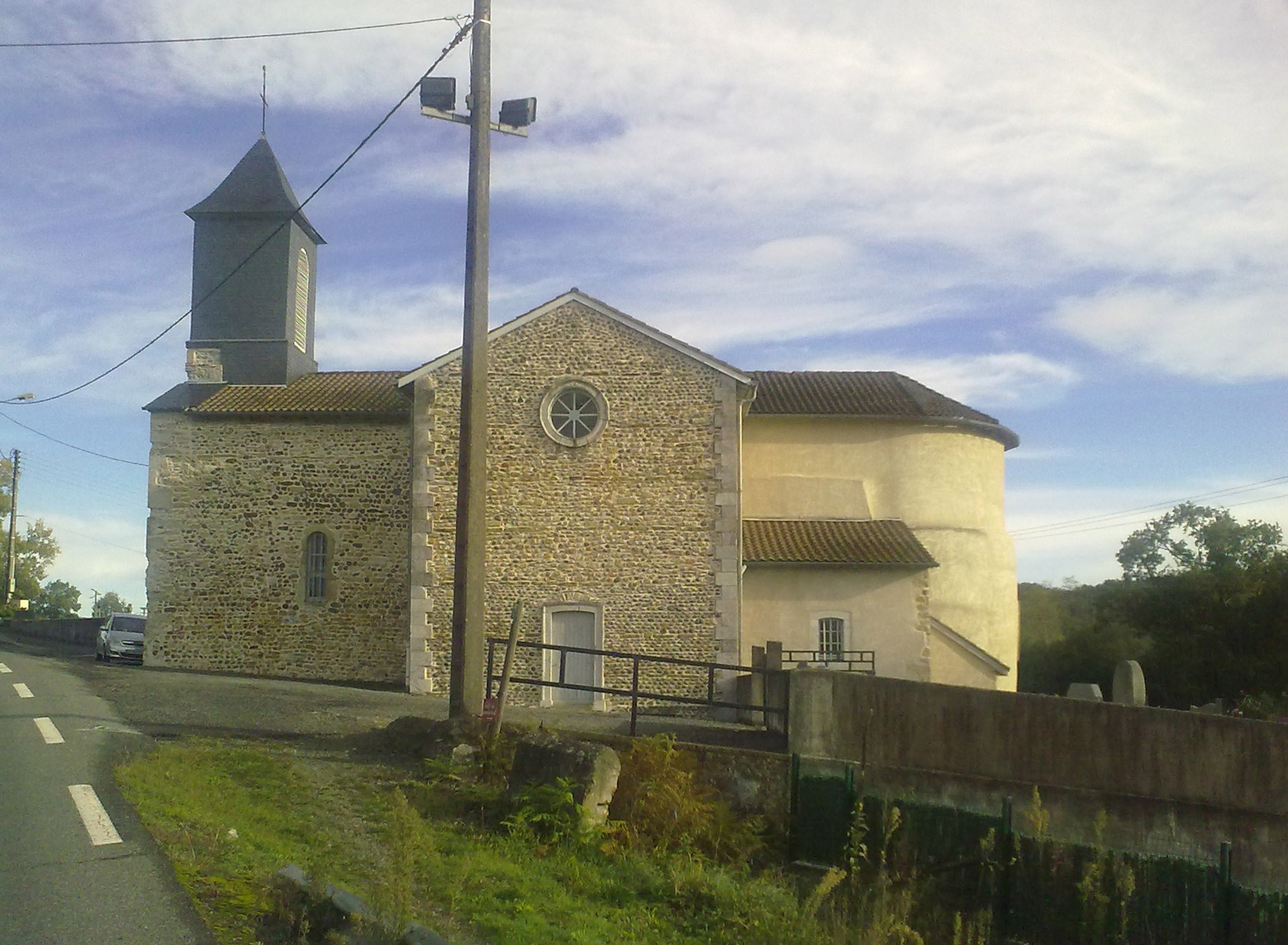
The Church of Saint-Pierre (11th century)![]() is registered as an historical monument.[19] It was built in 1866 on remains from the 11th century.
is registered as an historical monument.[19] It was built in 1866 on remains from the 11th century.
Facilities
Argagnon has a primary school.
Notable people linked to the commune
- Raymond Larrabure, born in 1797 in Saint-Jean-Pied-de-Port and died in 1875 in Argagnon, was a French politician.
- Henry de Pène, born in 1830 in Paris and died in 1888 in the same city, was a French writer and journalist. Henry de Pène was also called Henry de Pène of Argagnon - after the castle owned by his father at Argagnon.
- Robert Sarrabère, born in 1926 in Argagnon was a French Catholic bishop of Aire and Dax until his retirement in 2002. From 9 January to 2 September 2007, he served the diocese of Montauban as Apostolic Administrator during the period of transition from one bishop to another.
See also
References
- "Populations légales 2019". The National Institute of Statistics and Economic Studies. 29 December 2021.
- Inhabitants of Pyrénées-Atlantiques (in French)
- Google Maps
- Topographic Dictionary of the Department of Basses-Pyrenees, Paul Raymond, Imprimerie nationale, 1863, Digitised from Lyon Public Library 15 June 2011 (in French)
- Géoportail, IGN (in French)
- Brigitte Jobbé-Duval, Dictionary of place names - Pyrénées-Atlantiques, 2009, Archives and Culture, ISBN 978-2-35077-151-9 (in French)
- Cartulary of Bigorre, a Manuscript from the 15th century in the Departmental Archives of Pyrénées-Atlantiques (in French)
- Manuscript from 1376 in the Departmental Archives of Pyrénées-Atlantiques (in French)
- Manuscript from the 14th century - Departmental Archives of Pyrénées-Atlantiques (in French)
- Manuscript from the 16th to 18th centuries - Departmental Archives of Pyrénées-Atlantiques (in French)
- Manuscript from the 18th century in the Departmental Archives of Pyrénées-Atlantiques (in French)
- Notaries of Pardies in the Departmental Archives of Pyrénées-Atlantiques (in French)
- Review of Pau and Béarn, Nos. 10-11, Société des sciences, lettres et arts de Pau (in French)
- French Armorial: Cabaumont-Cordes, J. H. Willems, H. Lamant, Jean-Yves Conan (in French)
- List of Mayors of France (in French)
- Des villages de Cassini aux communes d'aujourd'hui: Commune data sheet Argagnon, EHESS. (in French)
- Population en historique depuis 1968, INSEE
- Lo Noste Béarn, Hubert Dutech, ISBN 978-2914709187, Monhélios, 2003 (Basque)
- Ministry of Culture, Mérimée IA64000509 Church of Saint-Pierre (in French)
External links
- Page on Argagnon on the Community of communes of Arthez-de-Béarn website (in French)
- Argagnon on Géoportail, National Geographic Institute (IGN) website (in French)
- Argagnon on the 1750 Cassini Map
На других языках
[de] Argagnon
Argagnon ist eine französische Gemeinde mit 702 Einwohnern (Stand 1. Januar 2019) im Département Pyrénées-Atlantiques in der Region Nouvelle-Aquitaine. Die Gemeinde gehört zum Arrondissement Pau und zum Kanton Artix et Pays de Soubestre (bis 2015: Kanton Arthez-de-Béarn).- [en] Argagnon
[ru] Арганьон
Арганьо́н (фр. Argagnon) — коммуна во Франции, находится в регионе Аквитания. Департамент — Атлантические Пиренеи. Входит в состав кантона Арти-э-Пеи-де-Субестр. Округ коммуны — По.Другой контент может иметь иную лицензию. Перед использованием материалов сайта WikiSort.org внимательно изучите правила лицензирования конкретных элементов наполнения сайта.
WikiSort.org - проект по пересортировке и дополнению контента Википедии