world.wikisort.org - France
Angous is a commune in the Pyrénées-Atlantiques department in the Nouvelle-Aquitaine region of southwestern France.
Angous | |
|---|---|
Commune | |
 The road into Angous | |
Location of Angous  | |
 Angous  Angous | |
| Coordinates: 43°17′41″N 0°48′45″W | |
| Country | France |
| Region | Nouvelle-Aquitaine |
| Department | Pyrénées-Atlantiques |
| Arrondissement | Oloron-Sainte-Marie |
| Canton | Le Cœur de Béarn |
| Intercommunality | Béarn des Gaves |
| Government | |
| • Mayor (2020–2026) | Francis Lansalot-Matras[1] |
| Area 1 | 6.22 km2 (2.40 sq mi) |
| Population | 97 |
| • Density | 16/km2 (40/sq mi) |
| Time zone | UTC+01:00 (CET) |
| • Summer (DST) | UTC+02:00 (CEST) |
| INSEE/Postal code | 64025 /64190 |
| Elevation | 133–262 m (436–860 ft) (avg. 177 m or 581 ft) |
| 1 French Land Register data, which excludes lakes, ponds, glaciers > 1 km2 (0.386 sq mi or 247 acres) and river estuaries. | |
The inhabitants of the commune are known as Angousiens or Angousiennes [3]
Geography
Angous is located some 5 km south-west of Navarrenx and 12 km north-east of Mauléon-Licharre. It can be accessed by the D2 road which runs from Navarrenx and forms the south-eastern border of the commune before continuing to Moncayolle-Larrory-Mendibieu. Access to the village is by the D69 road which runs off the D2 to the village. The commune consists of mainly farmland with patches of forest.[4]
Located on the watershed of the Adour, the Serrot, a tributary of the Lausset, with many tributaries flows through the commune from south-west to north-east passing near the village. The Ruisseau de Lassere with many tributaries also flows from the south-west towards the northeast to the east of the village and forms part of the eastern border.
Places and Hamlets
- Beigbédé
- Bestit
- Bois de Carrié
- Bonnehoun
- Bordenave
- Cabane
- Caillau[5]
- Carrié
- Chincas
- Claverie
- Denis
- Jaquet
- Labadie
- Labatut
- Labourdette
- Lagrave
- Lahaderne
- Larrieu
- Lartigue
- Lauga
- Ligaray
- Maréchal
- Miranda
- Mirassou
- Montjoye
- Mouliet
- Nabarre (ruins)
- Olive
- Parfouby
- Poumirau
- Pucheu
- Serbielle[5]
- Serrot[5]
- Trouilh
Neighbouring communes and villages
Places adjacent to Angous | ||||||||||||||||
|---|---|---|---|---|---|---|---|---|---|---|---|---|---|---|---|---|
| ||||||||||||||||
Toponymy
The commune name in Gascon is Angós which means "marshy terrain" according to Michel Grosclaude[6] and Brigitte Jobbé-Duval[7]
The following table details the origins of the commune name and other names in the commune.
| Name | Spelling | Date | Source | Page | Origin | Description |
|---|---|---|---|---|---|---|
| Angous | Angos | 1385 | Raymond | 6 | Census | Village |
| Anguos | 1548 | Raymond | 6 | Reformation | ||
| Saint-André d'Angous | 1673 | Raymond | 6 | Insinuations | ||
| Angous | 1750 | Cassini | ||||
| Angoust | 1793 | Ldh/EHESS/Cassini | ||||
| Angons | 1801 | Ldh/EHESS/Cassini | Bulletin des Lois | |||
| Caillau | Caillau | 1863 | Raymond | 39 | Fief | |
| Dalen | Dalen | 1863 | Raymond | 54 | Farm | |
| Les Navailles | Navaillez | 1366 | Raymond | 121 | Chapter of Navailles | Hamlet, former commune founded in 1366 |
| Los Nabalhes | 1385 | Raymond | 121 | Census | ||
| Los Navalhees d'Angos | 1412 | Raymond | 121 | Notaries | ||
| Los quoate Nabalhes | 1538 | Raymond | 121 | Reformation | ||
| Les Navaillès | 1593 | Raymond | 121 | Angous | ||
| Les Randuches | Les Randuches | 1366 | Raymond | 141 | Chapter of Navailles | Hamlet |
| Serbielle | Serviele | 1385 | Raymond | 160 | Census | Farm |
| Servielle | 1863 | Raymond | 160 | |||
| Serrot | Serrot | 1863 | Raymond | 160 | Census | Hamlet |
Sources:
- Raymond: Topographic Dictionary of the Department of Basses-Pyrenees, 1863, on the page numbers indicated in the table. (in French)[5]
- Grosclaude: Toponymic Dictionary of communes, Béarn, 2006 (in French)[6]
- Cassini: Cassini Map from 1750[8]
- Ldh/EHESS/Cassini: Des villages de Cassini aux communes d'aujourd'hui: Commune data sheet Angous, EHESS. (in French)
Origins:
- Census: Census of Béarn[9]
- Reformation: Reformation of Béarn[10]
- Insinuations: Insinuations of the Diocese of Oloron[11]
- Notaries: Notaries of Navarrenx[12]
- Angous: Titles of Angous.[13]
History
Paul Raymond noted on page 6 of the 1863 dictionary that the commune had a Lay Abbey, a vassal of the Viscount of Béarn. In 1385 there were 12 fires in Angous and it depended on the bailiwick of Navarrenx.[5]
The barony of Gabaston, a vassal of the Viscount of Béarn, was made up of Angous, Navailles, and Susmiou.[5]
Administration

This list is incomplete; you can help by adding missing items. (April 2021) |
List of Successive Mayors[14]
| From | To | Name |
|---|---|---|
| 1995 | 2001 | David Layous |
| 2001 | 2008 | Roger Eyheremendy |
| 2008 | 2026 | Francis Lansalot-Matras |
Inter-communality
The commune is part of six inter-communal structures:
- the Communauté de communes du Béarn des Gaves;
- the inter-communal association for Gaves and of Saleys;
- the mixed forestry association for the oak groves in the Basque and béarnais valleys;
- the collection association of Navarrenx;
- the AEP association of Navarrenx;
- the energy association of Pyrénées-Atlantiques.
Demography
In 2017 the commune had 102 inhabitants.
|
| ||||||||||||||||||||||||||||||||||||||||||||||||||||||||||||||||||||||||||||||||||||||||||||||||||||||||||||||||||
| Source: EHESS[15] and INSEE[16] | |||||||||||||||||||||||||||||||||||||||||||||||||||||||||||||||||||||||||||||||||||||||||||||||||||||||||||||||||||

Economy
The activity is directed mainly towards agriculture (livestock grazing, market gardening, and horticultural crops). The town is part of the Appellation d'origine contrôlée (AOC) zone of Ossau-iraty.
Culture and Heritage
Religious heritage
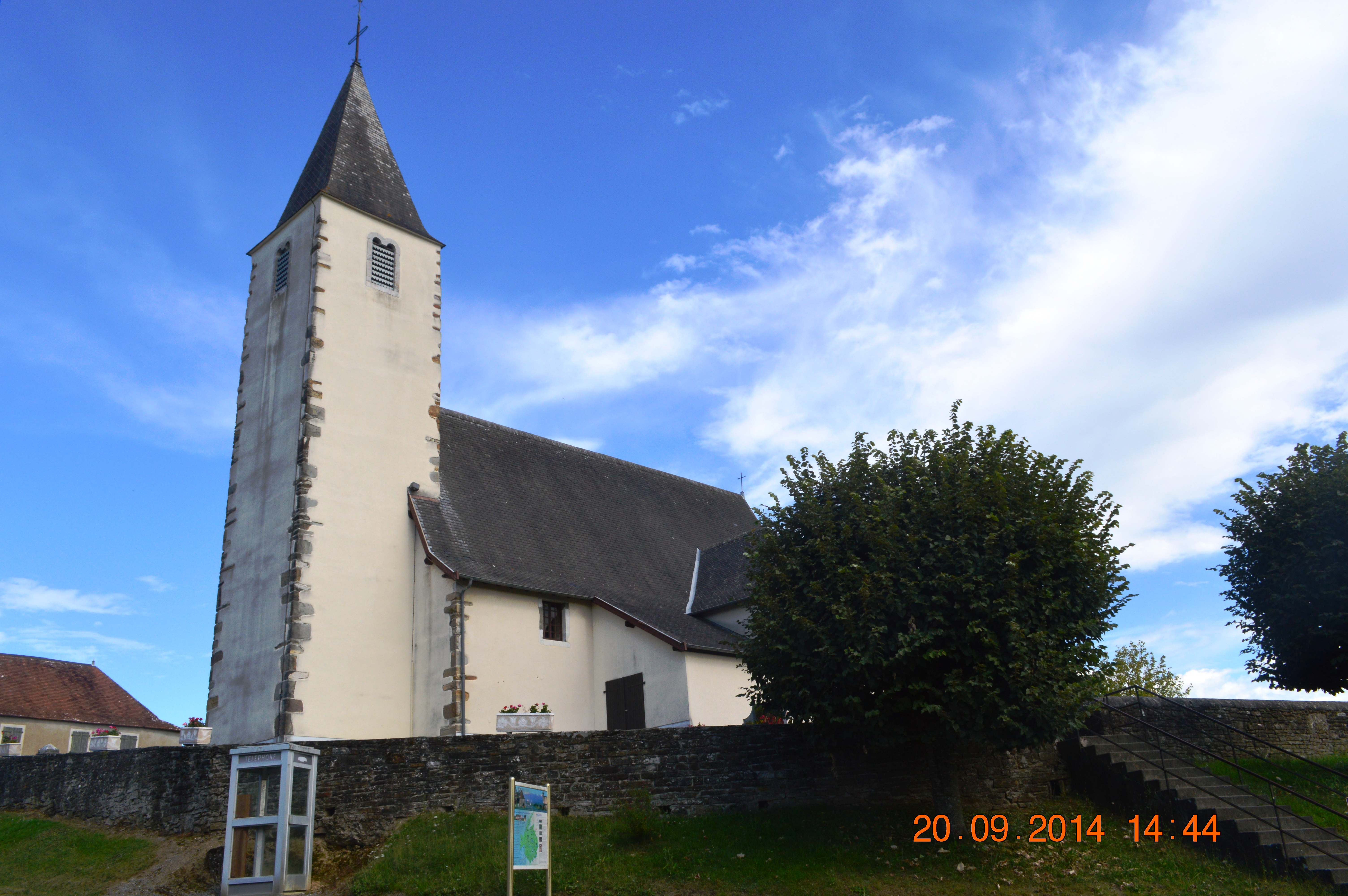
The Parish Church of Saint-André (1847)![]() is registered as an historical monument.[17]
is registered as an historical monument.[17]
- Church Gallery
 Church Interior
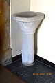 Baptismal Font


The sect Tabitha's place has a property of eleven hectares in the commune.
See also
References
- "Répertoire national des élus: les maires". data.gouv.fr, Plateforme ouverte des données publiques françaises (in French). 2 December 2020.
- "Populations légales 2019". The National Institute of Statistics and Economic Studies. 29 December 2021.
- Inhabitants of Pyrénées-Atlantiques (in French)
- Google Maps
- Topographic Dictionary of the Department of Basses-Pyrenees, Paul Raymond, Imprimerie nationale, 1863, Digitised from Lyon Public Library 15 June 2011 (in French)
- Michel Grosclaude, Toponymic Dictionary of communes, Béarn, Edicions reclams & Édition Cairn - 2006, 416 pages, ISBN 2-35068-005-3 (in French)
- Brigitte Jobbé-Duval, Dictionary of place names - Pyrénées-Atlantiques, 2009, Archives and Culture, ISBN 978-2-35077-151-9 (in French)
- Cassini Map 1750 – Angous
- Manuscript from the 14th century - Departmental Archives of Pyrénées-Atlantiques (in French)
- Manuscript from the 16th to 18th centuries - Departmental Archives of Pyrénées-Atlantiques (in French)
- Manuscripts from the 17th century in the Departmental Archives of Pyrénées-Atlantiques (in French)
- Notaries of Navarrenx in the Departmental Archives of Pyrénées-Atlantiques (in French)
- Titles of Angous in the Departmental Archives of Pyrénées-Atlantiques (in French)
- List of Mayors of France
- Des villages de Cassini aux communes d'aujourd'hui: Commune data sheet Angous, EHESS. (in French)
- Population en historique depuis 1968, INSEE
- Ministry of Culture, Mérimée IA64000569 Parish Church of Saint-André (in French)
External links
На других языках
[de] Angous
Angous ist eine französische Gemeinde mit 97 Einwohnern (Stand 1. Januar 2019) im Département Pyrénées-Atlantiques in der Region Nouvelle-Aquitaine (vor 2016: Aquitanien). Die Gemeinde gehört zum Arrondissement Oloron-Sainte-Marie und zum Kanton Le Cœur de Béarn (bis 2015: Kanton Navarrenx).- [en] Angous
[ru] Ангус (коммуна)
Ангу́с (фр. Angous) — коммуна во Франции, находится в регионе Новая Аквитания. Департамент — Атлантические Пиренеи. Входит в состав кантона Кёр-де-Беарн. Округ коммуны — Олорон-Сент-Мари.Другой контент может иметь иную лицензию. Перед использованием материалов сайта WikiSort.org внимательно изучите правила лицензирования конкретных элементов наполнения сайта.
WikiSort.org - проект по пересортировке и дополнению контента Википедии