world.wikisort.org - France
Annoisin-Chatelans (French pronunciation: [anwazɛ̃ ʃatlɑ̃]) is a commune in the Isère department in the Auvergne-Rhône-Alpes region of southeastern France.
Annoisin-Chatelans | |
|---|---|
Commune | |
 The heights of Chatelans | |
Location of Annoisin-Chatelans  | |
 Annoisin-Chatelans  Annoisin-Chatelans | |
| Coordinates: 45°45′28″N 5°17′39″E | |
| Country | France |
| Region | Auvergne-Rhône-Alpes |
| Department | Isère |
| Arrondissement | La Tour-du-Pin |
| Canton | Charvieu-Chavagneux |
| Government | |
| • Mayor (2020–2026) | Nora Chebbi[1] |
| Area 1 | 13.27 km2 (5.12 sq mi) |
| Population | 696 |
| • Density | 52/km2 (140/sq mi) |
| Time zone | UTC+01:00 (CET) |
| • Summer (DST) | UTC+02:00 (CEST) |
| INSEE/Postal code | 38010 /38460 |
| Elevation | 280–452 m (919–1,483 ft) |
| 1 French Land Register data, which excludes lakes, ponds, glaciers > 1 km2 (0.386 sq mi or 247 acres) and river estuaries. | |
The inhabitants of the commune are known as Nuisantins or Nuisantines[3]
Geography
The Village of Annoisin-chatelans is located on the foothills and the plateau of the Isle-Crémieu, some 40 km east of Lyon and just 2 km north-east of the town of Crémieu.
It is part of the Community of communes of l'Isle-Crémieu which includes all the communes around Crémieu, the plain side of Lyon with Chamagnieu and Villemoirieu next to the Optevoz hills area.
The commune is characterized by scattered settlements which comes from the merger of two towns of comparable size, Annoisin which faces Crémieu and Chatelans another two kilometres north which faces on to the valley of Amby (Hières-sur-Amby and Optevoz). There are also two other hamlets south of the village called Michalieu and Le Mollard.
Access to the commune is by the D521 minor road from Crémieu in the south passing through the heart of the commune and the village and continuing north then east to join the D52A to Optevoz. The commune is quite heavily forested in the north and along the eastern and western borders however the southern part of the commune is farmland.[4]
Neighbouring communes and villages
Places adjacent to Annoisin-Chatelans | |
|---|---|
History
The plateau of Larina has been occupied since the beginning of the first millennium. There are still traces on the Larina site north of the commune (an oppidum then a Merovingian camp).[5] The first known text on Annoisin was regarding the Parish and its Church in the 1172-1275 period of the Capetian Kings. Formerly attached to Optevoz,[citation needed] Chatelans was attached to the commune of Annoisin in 1842.[6]
Administration
This list is incomplete; you can help by adding missing items. (April 2021) |
List of Successive Mayors[7]
| From | To | Name | Party |
|---|---|---|---|
| 1969 | 1993 | Clément Gauthier | ind. |
| 2001 | 2014 | Yves Gentil | |
| 2014 | 2026 | Nora Chebbi |
Demography
In 2017 the commune had 676 inhabitants. The population data given in the table and graph below for 1836 and earlier refer to the former commune of Annoisin.
|
| ||||||||||||||||||||||||||||||||||||||||||||||||||||||||||||||||||||||||||||||||||||||||||||||||||||||||||||||||||
| Source: EHESS[6] and INSEE[8] | |||||||||||||||||||||||||||||||||||||||||||||||||||||||||||||||||||||||||||||||||||||||||||||||||||||||||||||||||||
Culture and heritage
Civil heritage
The commune has a number of buildings and sites that are registered as historical monuments:
- An Archaeological Site
 [9]
[9] - The Domain de la Tour House (1789)[10]
- The War Memorial (1921)[11]
- A House at le Mollard (1580)[12]
- A Primary School at Chatelans (19th century)[13]
- A Farmhouse at Chatelans (1760)[14]
- The Town Hall (formerly a Primary School) (1882)[15]
Religious heritage
The commune has two religious buildings and sites that are registered as historical monuments:
- The Parish Church of Notre-Dame (12th century)[16] The Church contains several items that are registered as historical objects:
- The Cemetery (1863)[20] The Cemetery contains several items that are registered as historical objects:
Environmental heritage

This small village in northern Isère has retained many of its houses made of golden stone extracted from quarries that are still used, its surprising octagonal tower, its communal ovens and lavoirs (Public laundries) hidden in the green meadows. The curiosity of the commune, it is precisely the number of bread ovens and lavoirs whether at Annoisin with one oven; or Chatelans with two ovens, a lavoir, and a fountain in the lower part of the village; or the hamlet of Michalieu with a beautiful collection of a bread oven with a lavoir and its cross.
There are many marked trails that wind through the woods and the blue juniper bushes found in abundance on the limestone plateau. They thrive on the edge of beautiful cliffs overlooking the Rhone valley or on the hills where the top of the Alps and Mont Blanc can be seen.
Picture Gallery
 The 1851 Jubilee Cross
 Annoisin Church
 The old manor house
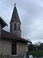 The Church Tower
 The bread oven at Michalieu
 The bread oven at Chatelans
 The lavoir at Michalieu
 The fountain-lavoir at Chatelans


See also
References
- "Répertoire national des élus: les maires". data.gouv.fr, Plateforme ouverte des données publiques françaises (in French). 2 December 2020.
- "Populations légales 2019". The National Institute of Statistics and Economic Studies. 29 December 2021.
- Inhabitants of Isère (in French)
- Google Maps
- F. Perrin, A deposit of Gallic Objects at Larina, DARA,1990. (in French)
- Des villages de Cassini aux communes d'aujourd'hui: Commune data sheet Annoisin-Chatelans, EHESS. (in French)
- List of Mayors of France
- Population en historique depuis 1968, INSEE
- Ministry of Culture, Mérimée PA00117116 Archaeological site (in French)
- Ministry of Culture, Mérimée IA38000217 Domain de la Tour (in French)
- Ministry of Culture, Mérimée IA38000215 War Memorial (in French)
- Ministry of Culture, Mérimée IA38000214 House at le Mollard (in French)
- Ministry of Culture, Mérimée IA38000213 Primary School at Chatelans (in French)
- Ministry of Culture, Mérimée IA38000123 Farmhouse at Chatelans (in French)
- Ministry of Culture, Mérimée IA38000050 Town Hall (in French)
- Ministry of Culture, Mérimée IA38000218 Parish Church of Notre-Dame (in French)
- Ministry of Culture, Palissy IM38000660 Pulpit (in French)
- Ministry of Culture, Palissy IM38000659 Confessional (in French)
- Ministry of Culture, Palissy IM38000658 Furniture in the Church (in French)
- Ministry of Culture, Mérimée IA38000216 Cemetery (in French)
- Ministry of Culture, Palissy IM38000657 Priest's Tomb (in French)
- Ministry of Culture, Palissy IM38000656 Tomb of Benoît Parent (in French)
- Ministry of Culture, Palissy IM38000655 Cemetery Cross (in French)
External links
- Annoisin-Chatelans on the National Geographic Institute website (in French)
- Annoisin-Chatelans on Géoportail, National Geographic Institute (IGN) website (in French)
- Annoizin and Chatelan on the 1750 Cassini Map
Authority control | |
|---|---|
| General |
|
| National libraries | |
На других языках
[de] Annoisin-Chatelans
Annoisin-Chatelans ist eine französische Gemeinde mit 696 Einwohnern (Stand: 1. Januar 2019) im Département Isère in der Region Auvergne-Rhône-Alpes. Villemoirieu liegt im Arrondissement La Tour-du-Pin und im Kanton Charvieu-Chavagneux (bis 2015: Kanton Crémieu). Die Einwohner werden Niusantins genannt.- [en] Annoisin-Chatelans
[fr] Annoisin-Chatelans
Annoisin-Chatelans est une commune française située dans le département de l'Isère et la région Auvergne-Rhône-Alpes.[ru] Аннуазен-Шатлан
Аннуазен-Шатлан (фр. Annoisin-Chatelans) — коммуна во Франции, находится в регионе Рона — Альпы. Департамент коммуны — Изер. Входит в состав кантона Кремьё. Округ коммуны — Тур-дю-Пен[1].Другой контент может иметь иную лицензию. Перед использованием материалов сайта WikiSort.org внимательно изучите правила лицензирования конкретных элементов наполнения сайта.
WikiSort.org - проект по пересортировке и дополнению контента Википедии