world.wikisort.org - France
Saint-Chef (French pronunciation: [sɛ̃ ʃɛf]) is a commune in the Isère department in southeastern France.[2][3]
This article uses bare URLs, which are uninformative and vulnerable to link rot. (August 2022) |
This article may be expanded with text translated from the corresponding article in French. (December 2009) Click [show] for important translation instructions.
|
Saint-Chef | |
|---|---|
Commune | |
 Tour du Poulet | |
 Coat of arms | |
Location of Saint-Chef  | |
 Saint-Chef  Saint-Chef | |
| Coordinates: 45°38′05″N 5°21′59″E | |
| Country | France |
| Region | Auvergne-Rhône-Alpes |
| Department | Isère |
| Arrondissement | La Tour-du-Pin |
| Canton | Bourgoin-Jallieu |
| Government | |
| • Mayor (2020–2026) | Alexandre Drogoz |
| Area 1 | 27.16 km2 (10.49 sq mi) |
| Population | 3,689 |
| • Density | 140/km2 (350/sq mi) |
| Time zone | UTC+01:00 (CET) |
| • Summer (DST) | UTC+02:00 (CEST) |
| INSEE/Postal code | 38374 /38890 |
| Elevation | 218–440 m (715–1,444 ft) |
| 1 French Land Register data, which excludes lakes, ponds, glaciers > 1 km2 (0.386 sq mi or 247 acres) and river estuaries. | |
The commune is named after Saint Chef, who was born in the nearby hamlet of Arcisse.
climate
Saint-Chef has a semi-continental climate[4] characterized by generally higher rainfall in spring and summer than in winter.
However, summers are hot and experience many intense stormy periods. Winters are generally quite cold and marked by frequent frosts, especially since the sector which has remained marshy for a very long time is often marked by numerous morning mists and more or less persistent fogs during cold periods.
Hydrology
The territory of Saint-Chef is criss-crossed by two small streams, the Saint-Savin stream to the south and the Ver stream to the north.
History
The abbey Saint-Chef develops over time. The abbey church dates from the 10th and 11th centuries. A first castle is built on the north hill. It will be followed by two others, later, still on the same hill but further west. After the French Revolution, the abbey was dismantled and its buildings re-used for the most part, or destroyed for some others.
Between 1790 and 1794, Saint-Chef absorbed the communes of Arcisses, Chamont, Crucilleux, Laval-de-Saint-Chef, Montcarra, Trieux and Vercin.
The current mayor is Alexandre Drogoz who replaced Noël Rolland in 2020.
Abbey of Saint-Chef
This abbey was founded around the year 500. The 12th and 13th century Saint-Theudère church, with its flamboyant Gothic portal and its organ,[5] was listed as a historic monument in 1840 by Prosper Mérimée.[6]
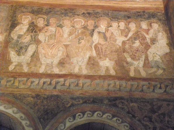
The main building houses one of the most important sets of Romanesque frescoes in France dating from the twelfth century, on the theme of the Apocalypse, also classified as a historic monument.[7] The historical and artistic interest of its frescoes has earned them reproductions in the Cité de l'Architecture et du Patrimoine of Paris.
- Quelques photos de l'abbaye de Saint-Chef
 Vue générale de l'abbatiale.
 La façade ouest.
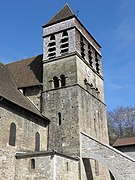 Le clocher.
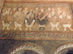 Fresque : les Vieillards de l'Apocalypse.
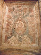 Fresque : le Christ en majesté.
 Fresque : les apôtres.


Saint-Barthélémy de Chamont church
Located three kilometers from the main body of the village, in the hamlet of Chamont, this church was erected in 1879. In 1982, it became disused but, in 2001, an association close to the Lyon priory of the Priestly Fraternity of Saint-Pie-X bought building. Since then, it has been served by its priests officiating there according to the Tridentine form of the Roman rite.
Notable residents
- Hugh of Saint-Cher
- Antoine Pécaudy de Contrecœur
See also
References
- "Populations légales 2019". The National Institute of Statistics and Economic Studies. 29 December 2021.
- INSEE commune file
- Barbara Franzé, La Pierre et l'image. L'église de Saint-Chef-en-Dauphiné, Paris, Picard, 2011, 284 p., 273 ill. (ISBN 978-2-7084-0877-7)
- http://www.auvergne-rhone-alpes.developpement-durable.gouv.fr/
- Base Palissy: Orgue de tribune, Ministère français de la Culture. (in French)
- Base Mérimée: Eglise Saint-Theudère, Ministère français de la Culture. (in French)
- Base Palissy: Peinture monumentale, Ministère français de la Culture. (in French)
- Content in this edit is translated from the existing French Wikipedia article at fr:Église Saint-Theudère de Saint-Chef
Authority control | |
|---|---|
| General |
|
| National libraries | |
| Other |
|
На других языках
[de] Saint-Chef
Saint-Chef ist eine französische Gemeinde mit 3689 Einwohnern (Stand: 1. Januar 2019) im Département Isère in der Region Auvergne-Rhône-Alpes. Sie gehört zum Arrondissement La Tour-du-Pin und zum Kanton Bourgoin-Jallieu. Die Einwohner werden Saint-Cheffois(es) genannt.- [en] Saint-Chef
[es] Saint-Chef
Saint-Chef es una población y comuna francesa, en la región de Ródano-Alpes, departamento de Isère, en el distrito de La Tour-du-Pin y cantón de Bourgoin-Jallieu-Nord.[ru] Сен-Шеф
Сен-Шеф (фр. Saint-Chef) — коммуна во Франции, находится в регионе Рона — Альпы. Департамент коммуны — Изер. Входит в состав кантона Бургуен-Жалье-Нор. Округ коммуны — Ла-Тур-дю-Пен.[1]Другой контент может иметь иную лицензию. Перед использованием материалов сайта WikiSort.org внимательно изучите правила лицензирования конкретных элементов наполнения сайта.
WikiSort.org - проект по пересортировке и дополнению контента Википедии