world.wikisort.org - USA
Winter Park is a home rule municipality in Grand County, Colorado, United States. The permanent population was 999 at the 2010 census,[7] although with 2,572 housing units within the town limits[7] the seasonal population can be much higher.
Winter Park, Colorado | |
|---|---|
Town | |
 Part of downtown Winter Park with the Continental Divide in the background | |
| Motto: Colorado's Highest | |
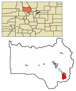 Location of Winter Park in Grand County, Colorado. | |
| Coordinates: 39°54′15″N 105°46′45″W | |
| Country | United States |
| State | Colorado |
| County[1] | Grand County |
| Founded | August 1, 1978 |
| Incorporated | September 1, 1979[2] |
| Government | |
| • Type | Home rule municipality[1] |
| • Mayor | Nick Kutrumbos |
| Area | |
| • Total | 16.89 sq mi (43.74 km2) |
| • Land | 16.89 sq mi (43.74 km2) |
| • Water | 0.00 sq mi (0.00 km2) |
| Elevation | 9,052 ft (2,780 m) |
| Population (2010) | |
| • Total | 999 |
| • Estimate (2019)[5] | 1,090 |
| • Density | 64.54/sq mi (24.92/km2) |
| Time zone | UTC-7 (MST) |
| • Summer (DST) | UTC-6 (MDT) |
| ZIP code[6] | 80482 (PO Box) |
| Area code | 970 |
| FIPS code | 08-85705 |
| GNIS feature ID | 0180960 |
| Website | www |
Highest incorporated town in the U.S. | |
It is home to Winter Park Resort, a ski resort owned by the City of Denver and managed by Alterra Mountain Company. The town and resort are served by the Winter Park Express ski train run by Amtrak. The area also has cross-country skiing opportunities, including Devil's Thumb Ranch. In the spring and summer, Winter Park is known for mountain biking, concerts, hiking, and fishing.
Geography
Winter Park is located in southeastern Grand County at 39°54′15″N 105°46′45″W,[8] at the southern end of the Fraser Valley. It is bordered to the north by the town of Fraser. U.S. Route 40 passes through the town, leading south and east over Berthoud Pass 66 miles (106 km) to Denver and northwest 20 miles (32 km) to Granby.
According to the United States Census Bureau, the town has a total area of 16.5 square miles (42.7 km2).[7]
Its elevation ranges from approximately 8,700 to 12,060 feet (2,650 to 3,680 m) above sea level, and is considered sub-alpine country. It is snow-covered for about six months a year. Although the town center is at about 9,000 feet (2,700 m) above sea level,[9] Winter Park, using administrative boundaries as a measure, became the highest incorporated town in the United States after the July 2006 annexation of 5,214 acres (21.10 km2) of Winter Park Resort to allow new on-mountain improvements. This claim is disputed since Winter Park has no residences above 9,550 feet (2,910 m), while contiguous residential neighborhoods in Leadville, Colorado, extend to 10,360 feet (3,160 m) and in Alma, Colorado, to 11,680 feet (3,560 m), and Alma's town center is at 10,361 feet (3,158 m).
Climate
According to the Köppen Climate Classification system, Winter Park has a subarctic climate, abbreviated "Dfc" on climate maps.
| Climate data for Winter Park, Colorado, 1991–2020 normals | |||||||||||||
|---|---|---|---|---|---|---|---|---|---|---|---|---|---|
| Month | Jan | Feb | Mar | Apr | May | Jun | Jul | Aug | Sep | Oct | Nov | Dec | Year |
| Average high °F (°C) | 30.4 (−0.9) |
34.5 (1.4) |
39.1 (3.9) |
49.9 (9.9) |
58.6 (14.8) |
69.7 (20.9) |
76.1 (24.5) |
74.1 (23.4) |
64.7 (18.2) |
53.8 (12.1) |
39.1 (3.9) |
32.4 (0.2) |
51.9 (11.0) |
| Daily mean °F (°C) | 14.8 (−9.6) |
17.8 (−7.9) |
22.4 (−5.3) |
33.6 (0.9) |
42.2 (5.7) |
50.2 (10.1) |
56.6 (13.7) |
54.6 (12.6) |
45.6 (7.6) |
37.0 (2.8) |
23.3 (−4.8) |
16.5 (−8.6) |
34.6 (1.4) |
| Average low °F (°C) | −0.9 (−18.3) |
1.1 (−17.2) |
5.7 (−14.6) |
17.2 (−8.2) |
25.8 (−3.4) |
30.6 (−0.8) |
37.0 (2.8) |
35.1 (1.7) |
26.5 (−3.1) |
20.2 (−6.6) |
7.4 (−13.7) |
0.6 (−17.4) |
17.2 (−8.2) |
| Average precipitation inches (mm) | 2.13 (54) |
2.29 (58) |
2.54 (65) |
3.34 (85) |
2.42 (61) |
1.49 (38) |
2.16 (55) |
2.01 (51) |
1.77 (45) |
1.88 (48) |
2.17 (55) |
2.20 (56) |
26.4 (671) |
| Average snowfall inches (cm) | 33.2 (84) |
30.8 (78) |
31.9 (81) |
31.5 (80) |
11.2 (28) |
1.0 (2.5) |
0.0 (0.0) |
0.0 (0.0) |
1.3 (3.3) |
14.2 (36) |
26.8 (68) |
32.1 (82) |
214 (542.8) |
| Average precipitation days (≥ 0.01 in) | 13.0 | 11.3 | 11.0 | 11.0 | 9.5 | 7.2 | 10.2 | 11.6 | 8.7 | 8.2 | 10.7 | 11.7 | 124.1 |
| Average snowy days (≥ 0.1 in) | 12.3 | 11.0 | 10.4 | 9.6 | 3.8 | 0.3 | 0.0 | 0.0 | 0.6 | 5.3 | 9.7 | 10.7 | 73.7 |
| Source 1: NOAA[10] | |||||||||||||
| Source 2: WRCC (average high, mean, low 1942-2016)[11] | |||||||||||||
Demographics
| Historical population | |||
|---|---|---|---|
| Census | Pop. | %± | |
| 1980 | 480 | — | |
| 1990 | 528 | 10.0% | |
| 2000 | 662 | 25.4% | |
| 2010 | 999 | 50.9% | |
| 2019 (est.) | 1,090 | [5] | 9.1% |
| U.S. Decennial Census[12] | |||
As of the census[13] of 2000, there were 662 people, 318 households, and 129 families residing in the town. The population density was 82.1 people per square mile (31.7/km2). There were 1,231 housing units at an average density of 152.7 per square mile (59.0/km2). The racial makeup of the town was 96.53% White, 0.15% African American, 0.60% Native American, 0.91% Asian, 0.45% from other races, and 1.36% from two or more races. Hispanics or Latinos of any race were 1.36% of the population.
There were 318 households, out of which 14.8% had children under the age of 18 living with them, 33.3% were married couples living together, 5.0% had a female householder with no husband present, and 59.4% were non-families. 38.4% of all households were made up of individuals, and 4.4% had someone living alone who was 65 years of age or older. The average household size was 2.04 and the average family size was 2.67.
The age distribution was 12.5% under the age of 18, 11.5% from 18 to 24, 44.0% from 25 to 44, 27.0% from 45 to 64, and 5.0% who were 65 years of age or older. The median age was 36 years. For every 100 females, there were 143.4 males. For every 100 females age 18 and over, there were 143.3 males.
The median income for a household in the town was $44,000, and the median income for a family was $80,660. Males had a median income of $35,221 versus $27,500 for females. The per capita income for the town was $36,699. About 3.3% of families and 9.2% of the population were below the poverty line, including 6.8% of those under age 18 and none of those age 65 or over.
Notable people
- Elizabeth McIntyre (born 1965), freestyle skier, Olympic silver medalist; lives in Winter Park
- Ryan Max Riley (born 1979), freestyle skier, US Champion, and humorist; lived in Winter Park
- Michelle Roark (born 1974), freestyle skier, World Champion silver medalist and two-time Olympian; lived in Winter Park
- Ryan St. Onge (born 1983), freestyle skier, World Champion and two-time Olympian; lived in Winter Park
See also
- Outline of Colorado
- Index of Colorado-related articles
- State of Colorado
- Colorado cities and towns
- Colorado municipalities
- Colorado counties
- Colorado cities and towns
- Arapaho National Forest
- Front Range
- Winter Park Resort
- Moffat Tunnel
References
- "Active Colorado Municipalities". State of Colorado, Department of Local Affairs. Retrieved 2007-09-01.
- "Colorado Municipal Incorporations". State of Colorado, Department of Personnel & Administration, Colorado State Archives. 2004-12-01. Retrieved 2007-09-02.
- "2019 U.S. Gazetteer Files". United States Census Bureau. Retrieved July 1, 2020.
- "US Board on Geographic Names". United States Geological Survey. 2007-10-25. Retrieved 2008-01-31.
- "Population and Housing Unit Estimates". United States Census Bureau. May 24, 2020. Retrieved May 27, 2020.
- "ZIP Code Lookup" (JavaScript/HTML). United States Postal Service. Retrieved January 9, 2008.
- "Geographic Identifiers: 2010 Demographic Profile Data (G001): Winter Park town, Colorado". American Factfinder. U.S. Census Bureau. Retrieved November 18, 2016.[dead link]
- "US Gazetteer files: 2010, 2000, and 1990". United States Census Bureau. 2011-02-12. Retrieved 2011-04-23.
- City of Winter Park official web site, Retrieved February 22, 2007.
- "U.S. Climate Normals Quick Access". National Oceanic and Atmospheric Administration. Retrieved September 9, 2022.
- "Period of Record Monthly Climate Summary". Western Regional Climate Center. Retrieved September 9, 2022.
- "Census of Population and Housing". Census.gov. Retrieved June 4, 2015.
- "U.S. Census website". United States Census Bureau. Retrieved 2008-01-31.
External links
- Town of Winter Park official website
- The Lift public transit system
- CDOT map of the Town of Winter Park
- Winter Park Resort
- Winter Park History
- 3dSkiMap of Winter Park
 Winter Park (Colorado) travel guide from Wikivoyage
Municipalities and communities of Grand County, Colorado, United States | ||
|---|---|---|
County seat: Hot Sulphur Springs | ||
| Towns |  | |
| CDPs | ||
| Unincorporated communities |
| |
| Ghost towns |
| |
| ||
Authority control | |
|---|---|
| General | |
| National libraries | |
| Other | |
На других языках
[de] Winter Park (Colorado)
Winter Park ist ein Dorf im Grand County im US-Bundesstaat Colorado mit 946 Einwohnern (Stand: 2013) und ist neben dem rund 80 km südwestlich gelegenen Vail eines der größten Skigebiete der USA sowie Heimat des Winter Park Resort, dessen Eigentümer der Ort selbst und das Denver County ist. Außerhalb der Ski-Saison bietet der Ort Möglichkeiten zum Wandern, Mountain-Biken, Klettern und Fischen.- [en] Winter Park, Colorado
Другой контент может иметь иную лицензию. Перед использованием материалов сайта WikiSort.org внимательно изучите правила лицензирования конкретных элементов наполнения сайта.
WikiSort.org - проект по пересортировке и дополнению контента Википедии