world.wikisort.org - USA
Thomas County (standard abbreviation: TH) is a county located in the U.S. state of Kansas. As of the 2020 census, the county population was 7,930.[2] Its county seat is Colby.[3]
Thomas County | |
|---|---|
County | |
 Thomas County Courthouse in Colby (2014) | |
 Location within the U.S. state of Kansas | |
 Kansas's location within the U.S. | |
| Coordinates: 39°21′N 101°03′W | |
| Country | |
| State | |
| Founded | October 8, 1885 |
| Named for | George Henry Thomas[1] |
| Seat | Colby |
| Largest city | Colby |
| Area | |
| • Total | 1,075 sq mi (2,780 km2) |
| • Land | 1,075 sq mi (2,780 km2) |
| • Water | 0.1 sq mi (0.3 km2) 0.01% |
| Population (2020)[2] | |
| • Total | 7,930 |
| • Density | 7.4/sq mi (2.9/km2) |
| Time zone | UTC−6 (Central) |
| • Summer (DST) | UTC−5 (CDT) |
| Congressional district | 1st |
| Website | ThomasCountyKS.com |
History
Early history
For many millennia, the Great Plains of North America was inhabited by nomadic Native Americans. From the 16th century to 18th century, the Kingdom of France claimed ownership of large parts of North America. In 1762, after the French and Indian War, France secretly ceded New France to Spain, per the Treaty of Fontainebleau.
19th century
In 1802, Spain returned most of the land to France, but keeping title to about 7,500 square miles. In 1803, most of the land for modern day Kansas was acquired by the United States from France as part of the 828,000 square mile Louisiana Purchase for 2.83 cents per acre.
In 1854, the Kansas Territory was organized, then in 1861 Kansas became the 34th U.S. state. Thomas County was founded on October 8, 1885. It was named for George Henry Thomas, a Union general during the American Civil War, hero of the Battle of Chickamauga. The townships of the county were named after the soldiers that died at the Battle of Chickamauga.[4]
Geography
According to the U.S. Census Bureau, the county has a total area of 1,075 square miles (2,780 km2), of which 1,075 square miles (2,780 km2) is land and 0.1 square miles (0.26 km2) (0.01%) is water.[5]
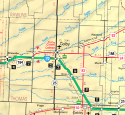
Major highways
 Interstate 70
 U.S. Highway 24
 U.S. Highway 83
 Kansas Highway 25
Adjacent counties
- Rawlins County (north)
- Decatur County (northeast)
- Sheridan County (east)
- Gove County (southeast)
- Logan County (south)
- Sherman County (west/Mountain Time border)
Demographics
| Historical population | |||
|---|---|---|---|
| Census | Pop. | %± | |
| 1880 | 161 | — | |
| 1890 | 5,538 | 3,339.8% | |
| 1900 | 4,112 | −25.7% | |
| 1910 | 5,455 | 32.7% | |
| 1920 | 5,517 | 1.1% | |
| 1930 | 7,334 | 32.9% | |
| 1940 | 6,425 | −12.4% | |
| 1950 | 7,572 | 17.9% | |
| 1960 | 7,358 | −2.8% | |
| 1970 | 7,501 | 1.9% | |
| 1980 | 8,451 | 12.7% | |
| 1990 | 8,258 | −2.3% | |
| 2000 | 8,180 | −0.9% | |
| 2010 | 7,900 | −3.4% | |
| 2020 | 7,930 | 0.4% | |
| U.S. Decennial Census[6] 1790-1960[7] 1900-1990[8] 1990-2000[9] 2010-2020[2] | |||
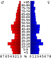
As of the census[10] of 2000, there were 8,180 people, 3,226 households, and 2,125 families residing in the county. The population density was 8 people per square mile (3/km2). There were 3,562 housing units at an average density of 3 per square mile (1/km2). The racial makeup of the county was 97.14% White, 0.43% Black or African American, 0.33% Native American, 0.27% Asian, 0.02% Pacific Islander, 0.95% from other races, and 0.86% from two or more races. 1.85% of the population were Hispanic or Latino of any race.
There were 3,226 households, out of which 32.90% had children under the age of 18 living with them, 56.10% were married couples living together, 6.90% had a female householder with no husband present, and 34.10% were non-families. 28.40% of all households were made up of individuals, and 11.70% had someone living alone who was 65 years of age or older. The average household size was 2.45 and the average family size was 3.04.
In the county, the population was spread out, with 26.30% under the age of 18, 13.50% from 18 to 24, 24.40% from 25 to 44, 21.20% from 45 to 64, and 14.60% who were 65 years of age or older. The median age was 35 years. For every 100 females there were 94.60 males. For every 100 females age 18 and over, there were 91.50 males.
The median income for a household in the county was $37,034, and the median income for a family was $45,931. Males had a median income of $33,833 versus $21,310 for females. The per capita income for the county was $19,028. About 6.60% of families and 9.70% of the population were below the poverty line, including 5.90% of those under age 18 and 7.50% of those age 65 or over.
Government
Presidential elections
Thomas County is strongly Republican, and has increasingly been this way over the past few election cycles. The last time a Democratic candidate has carried Thomas County was in 1964 by Lyndon B. Johnson.
| Year | Republican | Democratic | Third party | |||
|---|---|---|---|---|---|---|
| No. | % | No. | % | No. | % | |
| 2020 | 3,130 | 82.15% | 625 | 16.40% | 55 | 1.44% |
| 2016 | 2,908 | 81.32% | 473 | 13.23% | 195 | 5.45% |
| 2012 | 2,788 | 80.25% | 598 | 17.21% | 88 | 2.53% |
| 2008 | 2,837 | 77.24% | 787 | 21.43% | 49 | 1.33% |
| 2004 | 3,007 | 77.70% | 816 | 21.09% | 47 | 1.21% |
| 2000 | 2,822 | 74.66% | 807 | 21.35% | 151 | 3.99% |
| 1996 | 2,725 | 69.75% | 866 | 22.17% | 316 | 8.09% |
| 1992 | 1,849 | 47.14% | 932 | 23.76% | 1,141 | 29.09% |
| 1988 | 2,342 | 60.52% | 1,408 | 36.38% | 120 | 3.10% |
| 1984 | 3,107 | 76.70% | 887 | 21.90% | 57 | 1.41% |
| 1980 | 2,789 | 66.37% | 1,045 | 24.87% | 368 | 8.76% |
| 1976 | 2,246 | 53.94% | 1,802 | 43.28% | 116 | 2.79% |
| 1972 | 2,300 | 67.73% | 943 | 27.77% | 153 | 4.51% |
| 1968 | 1,971 | 59.82% | 1,074 | 32.59% | 250 | 7.59% |
| 1964 | 1,528 | 45.64% | 1,793 | 53.55% | 27 | 0.81% |
| 1960 | 2,081 | 61.50% | 1,285 | 37.97% | 18 | 0.53% |
| 1956 | 1,888 | 62.06% | 1,138 | 37.41% | 16 | 0.53% |
| 1952 | 2,490 | 69.46% | 1,069 | 29.82% | 26 | 0.73% |
| 1948 | 1,497 | 49.41% | 1,476 | 48.71% | 57 | 1.88% |
| 1944 | 1,631 | 59.14% | 1,097 | 39.78% | 30 | 1.09% |
| 1940 | 1,721 | 54.20% | 1,423 | 44.82% | 31 | 0.98% |
| 1936 | 1,200 | 35.42% | 2,168 | 63.99% | 20 | 0.59% |
| 1932 | 1,158 | 33.68% | 2,103 | 61.17% | 177 | 5.15% |
| 1928 | 1,828 | 65.97% | 899 | 32.44% | 44 | 1.59% |
| 1924 | 1,436 | 52.50% | 822 | 30.05% | 477 | 17.44% |
| 1920 | 1,046 | 54.56% | 747 | 38.97% | 124 | 6.47% |
| 1916 | 642 | 31.15% | 1,299 | 63.03% | 120 | 5.82% |
| 1912 | 127 | 14.16% | 432 | 48.16% | 338 | 37.68% |
| 1908 | 569 | 44.98% | 630 | 49.80% | 66 | 5.22% |
| 1904 | 548 | 56.96% | 205 | 21.31% | 209 | 21.73% |
| 1900 | 404 | 41.95% | 551 | 57.22% | 8 | 0.83% |
| 1896 | 304 | 38.00% | 490 | 61.25% | 6 | 0.75% |
| 1892 | 490 | 41.28% | 0 | 0.00% | 697 | 58.72% |
| 1888 | 751 | 55.02% | 486 | 35.60% | 128 | 9.38% |
Laws
Thomas County was a prohibition, or "dry", county until the Kansas Constitution was amended in 1986 and voters approved the sale of alcoholic liquor by the individual drink with a 30 percent food sales requirement.[12]
Education
Colleges
- Colby Community College
Unified school districts
- Brewster USD 314
- Colby USD 315
- Golden Plains USD 316
Communities
Cities
Unincorporated communities
- Halford
- Levant (CDP)
- Mingo
Townships
Thomas County is divided into thirteen townships. The townships were named in honor of men who were killed at the Battle of Chickamauga.[13] The city of Colby is considered governmentally independent and is excluded from the census figures for the townships. Geographically, Colby is surrounded by Morgan Township. In the following table, the population center is the largest city (or cities) included in that township's population total, if it is of a significant size.
| Township | FIPS | Population center |
Population | Population density /km2 (/sq mi) |
Land area km2 (sq mi) | Water area km2 (sq mi) | Water % | Geographic coordinates |
|---|---|---|---|---|---|---|---|---|
| Barrett | 04325 | 124 | 0 (1) | 276 (107) | 0 (0) | 0.01% | 39°30′21″N 101°16′7″W | |
| East Hale | 19475 | 137 | 1 (3) | 140 (54) | 0 (0) | 0% | 39°22′27″N 101°12′49″W | |
| Kingery | 36925 | 93 | 0 (1) | 373 (144) | 0 (0) | 0% | 39°13′55″N 101°16′52″W | |
| Lacey | 37425 | Gem | 132 | 1 (4) | 92 (36) | 0 (0) | 0% | 39°25′48″N 100°53′27″W |
| Menlo | 45775 | Menlo | 112 | 1 (2) | 140 (54) | 0 (0) | 0% | 39°20′36″N 100°46′4″W |
| Morgan | 48200 | Colby outskirts | 755 | 3 (7) | 271 (105) | 0 (0) | 0% | 39°22′31″N 101°3′0″W |
| North Randall | 51300 | 107 | 1 (2) | 138 (53) | 0 (0) | 0.03% | 39°19′44″N 100°53′55″W | |
| Rovohl | 61525 | 143 | 1 (1) | 277 (107) | 0 (0) | 0% | 39°30′11″N 101°4′3″W | |
| Smith | 65900 | Rexford | 213 | 2 (6) | 93 (36) | 0 (0) | 0.03% | 39°27′11″N 100°45′31″W |
| South Randall | 66875 | Oakley outskirts | 267 | 1 (2) | 279 (108) | 0 (0) | 0.04% | 39°10′59″N 100°50′29″W |
| Summers | 68975 | 197 | 1 (1) | 373 (144) | 0 (0) | 0% | 39°14′30″N 101°2′47″W | |
| Wendell | 76650 | 84 | 0 (1) | 183 (71) | 0 (0) | 0.02% | 39°31′4″N 100°49′21″W | |
| West Hale | 76975 | Brewster | 366 | 3 (7) | 140 (54) | 0 (0) | 0% | 39°21′50″N 101°21′48″W |
See also
|
|
References
- "A Brief History of Thomas County, Kansas and the Thomas County Courthouse". Thomas County, Kansas. Retrieved November 4, 2012.
- "QuickFacts; Thomas County, Kansas; Population, Census, 2020 & 2010". United States Census Bureau. Archived from the original on August 20, 2021. Retrieved August 20, 2021.
- "Find a County". National Association of Counties. Retrieved June 7, 2011.
- A Brief History of Thomas County, Kansas
- "US Gazetteer files: 2010, 2000, and 1990". United States Census Bureau. February 12, 2011. Retrieved April 23, 2011.
- "U.S. Decennial Census". United States Census Bureau. Retrieved July 29, 2014.
- "Historical Census Browser". University of Virginia Library. Retrieved July 29, 2014.
- "Population of Counties by Decennial Census: 1900 to 1990". United States Census Bureau. Retrieved July 29, 2014.
- "Census 2000 PHC-T-4. Ranking Tables for Counties: 1990 and 2000" (PDF). United States Census Bureau. Retrieved July 29, 2014.
- "U.S. Census website". United States Census Bureau. Retrieved January 31, 2008.
- "Dave Leip's Atlas of U.S. Presidential Elections".
- "Map of Wet and Dry Counties". Alcoholic Beverage Control, Kansas Department of Revenue. November 2006. Archived from the original on October 8, 2007. Retrieved December 28, 2007.
- "A Brief History of Thomas County, Kansas and the Thomas County Courthouse". County of Thomas, Kansas. Archived from the original on April 7, 2014. Retrieved June 27, 2014.
Further reading
- Standard Atlas of Thomas County, Kansas; Geo. A. Ogle & Co; 64 pages; 1907.
External links
- County
- Maps
- Thomas County Maps: Current, Historic, KDOT
- Kansas Highway Maps: Current, Historic, KDOT
- Kansas Railroad Maps: Current, 1996, 1915, KDOT and Kansas Historical Society
Places adjacent to Thomas County, Kansas | ||||||||||||||||
|---|---|---|---|---|---|---|---|---|---|---|---|---|---|---|---|---|
| ||||||||||||||||
Municipalities and communities of Thomas County, Kansas, United States | ||
|---|---|---|
County seat: Colby | ||
| Cities | 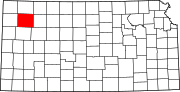 | |
| Unincorporated communities |
| |
| Ghost towns |
| |
| Footnotes | †This community is designated a Census-Designated Place (CDP) by the United States Census Bureau. ‡This community also has portions in an adjacent county or counties. | |
| ||
Topeka (capital) | ||
| Topics |
|  Seal of Kansas |
| Society |
| |
| Regions |
| |
| Largest cities |
| |
| Counties |
| |
| Lists |
| |
Authority control | |
|---|---|
| General | |
| National libraries | |
На других языках
- [en] Thomas County, Kansas
[ru] Томас (округ, Канзас)
Округ Томас (англ. Thomas County) располагается в штате Канзас, США. Официально образован 8-го октября 1885 года. По состоянию на 2010 год, численность населения составляла 7 900 человек.Другой контент может иметь иную лицензию. Перед использованием материалов сайта WikiSort.org внимательно изучите правила лицензирования конкретных элементов наполнения сайта.
WikiSort.org - проект по пересортировке и дополнению контента Википедии