world.wikisort.org - USA
Prairie Village is a city in Johnson County, Kansas, United States. It is part of the Kansas City Metropolitan Area. As of the 2020 census, the population of the city was 22,957.[2]
Prairie Village, Kansas | |
|---|---|
City | |
 Location within Johnson County and Kansas | |
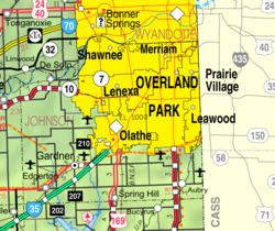 KDOT map of Johnson County (legend) | |
| Coordinates: 38°59′23″N 94°38′10″W | |
| Country | United States |
| State | Kansas |
| County | Johnson |
| Platted | 1941 |
| Incorporated | 1951 |
| Area | |
| • Total | 6.22 sq mi (16.11 km2) |
| • Land | 6.21 sq mi (16.09 km2) |
| • Water | 0.01 sq mi (0.03 km2) |
| Elevation | 988 ft (301 m) |
| Population (2020)[2] | |
| • Total | 22,957 |
| • Density | 3,700/sq mi (1,400/km2) |
| Time zone | UTC-6 (CST) |
| • Summer (DST) | UTC-5 (CDT) |
| Area code | 913 |
| FIPS code | 20-57575 [3] |
| GNIS ID | 0479232 [4] |
| Website | pvkansas.com |
History
After the successful development of the Country Club Plaza in Kansas City, Missouri, J. C. Nichols turned toward development of his native Johnson County, just a few miles from the Plaza. Prairie Village was platted in 1941 and was named after Prairie School, which was established almost a century before. In 1949, Prairie Village was named the best planned community in America by the National Association of Home Builders. It was officially recognized as a city in 1951.[citation needed]
Remnants of the Santa Fe Trail are found in the city.[citation needed]
Shawnee, Osage, and Kansa Indians formerly inhabited the land now developed into the City of Prairie Village. In 1858, Thomas Porter bought 160 acres of farmland in what is now Prairie Village; he raised all his children on that farmland and was involved in agricultural development and civic affairs.
Porter's sister, Betty Porter, married Thompson A. Lewis, who owned 80 acres between Mission Road and Roe Avenue.
Henry Coppock arrived in Johnson County in 1857, before heading farther west to work in freighting and farming. He came back in the mid-1860s and bought land in 1865. Coppock built his family home on 900 acres in Prairie Village. Coppock's house stood for 30 years. Now on his land is Homestead County Club.
The original Prairie School was built in 1882, and a new building was constructed in 1912. This landmark was a community treasure until 1990.
In the 1940s, J.C. Nichols, an experienced developer, wanted to turn the farmland into suburban housing for soldiers returning home from the war. Nichols bought farmland from the Porters, Coppocks, and Lewises. There were hurdles along the way including a lack of experienced builders after World War II, but this didn't stop Nichols from pursuing his goal.
Prairie Village continued to expand as the Prairie Village Shopping Center opened in 1947 and the Corinth Square Shopping Center opened in 1955.
Geography
Climate
| Climate data for Prairie Village, Kansas | |||||||||||||
|---|---|---|---|---|---|---|---|---|---|---|---|---|---|
| Month | Jan | Feb | Mar | Apr | May | Jun | Jul | Aug | Sep | Oct | Nov | Dec | Year |
| Record high °F (°C) | 74 (23) |
81 (27) |
85 (29) |
91 (33) |
95 (35) |
105 (41) |
114 (46) |
107 (42) |
106 (41) |
98 (37) |
84 (29) |
76 (24) |
114 (46) |
| Average high °F (°C) | 39 (4) |
44 (7) |
55 (13) |
65 (18) |
74 (23) |
83 (28) |
90 (32) |
89 (32) |
80 (27) |
68 (20) |
54 (12) |
41 (5) |
65 (18) |
| Daily mean °F (°C) | 30 (−1) |
34 (1) |
44 (7) |
55 (13) |
65 (18) |
74 (23) |
79 (26) |
77 (25) |
69 (21) |
58 (14) |
44 (7) |
32 (0) |
55 (13) |
| Average low °F (°C) | 20 (−7) |
24 (−4) |
33 (1) |
44 (7) |
55 (13) |
64 (18) |
72 (22) |
70 (21) |
61 (16) |
47 (8) |
34 (1) |
23 (−5) |
46 (8) |
| Record low °F (°C) | −18 (−28) |
−12 (−24) |
−8 (−22) |
13 (−11) |
30 (−1) |
43 (6) |
48 (9) |
46 (8) |
30 (−1) |
18 (−8) |
1 (−17) |
−22 (−30) |
−22 (−30) |
| Source: [5] | |||||||||||||
Demographics
| Historical population | |||
|---|---|---|---|
| Census | Pop. | %± | |
| 1960 | 25,356 | — | |
| 1970 | 28,378 | 11.9% | |
| 1980 | 24,657 | −13.1% | |
| 1990 | 23,186 | −6.0% | |
| 2000 | 22,072 | −4.8% | |
| 2010 | 21,447 | −2.8% | |
| 2020 | 22,957 | 7.0% | |
| U.S. Decennial Census 2010-2020[2] | |||
2020 census
As of the census[6] of 2020, there were 22,957 people and 9,955 households in the city.[7] The racial makeup of the city was 94.2% White, .9% African American, 0.1% Native American, 1.0% Asian, and 3.7% from two or more races. Hispanic or Latino of any race were 4.7% of the population.
There were 9,955 households. 21.9% had children under the age of 18. The average household size was 2.22.
21.9% of residents were under the age of 18 and 20.0% were 65 years of age or older. The gender makeup of the city was 45.2% male and 54.8% female.
2010 census
As of the census[6] of 2010, there were 21,447 people, 9,771 households, and 5,816 families living in the city.[8] The population density was 3,459.2 inhabitants per square mile (1,335.6/km2). There were 10,227 housing units at an average density of 1,649.5 per square mile (636.9/km2). The racial makeup of the city was 95.3% White, 1.0% African American, 0.2% Native American, 1.4% Asian, 0.5% from other races, and 1.6% from two or more races. Hispanic or Latino of any race were 3.4% of the population.
There were 9,771 households. 26.3% had children under the age of 18, 48.8% were married couples living together, 8.1% had a female householder with no husband present, 2.6% had a male householder with no wife present, and 40.5% were non-families. 34.1% of all households were made up of individuals, and 12.9% had someone living alone aged 65 years or older. The average household size was 2.18 and the average family size was 2.82.
The median age in the city was 41.4 years. 21% of residents were under the age of 18; 5% were between the ages of 18 and 24; 28.4% were from 25 to 44; 27.7% were from 45 to 64; and 17.9% were 65 years of age or older. The gender makeup of the city was 46.5% male and 53.5% female.
2000 census
As of the census[3] of 2000, there were 22,072 people, 9,833 households, and 6,165 families living in the city. The population density was 3,547.1 people per square mile (1,370.1/km2). There were 10,126 housing units at an average density of 1,627.3 per square mile (628.6/km2). The racial makeup of the city was 96.15% White, 0.78% African American, 0.16% Native American, 1.13% Asian, 0.03% Pacific Islander, 0.64% from other races, and 1.11% from two or more races. Hispanic or Latino of any race were 2.27% of the population.
There were 9,833 households. 26.6% had children under the age of 18, 52.8% were married couples living together, 7.9% had a female householder with no husband present, and 37.3% were non-families. 32.6% of all households were made up of individuals, and 13.8% had someone living alone who was 65 years of age or older. The average household size was 2.23 and the average family size was 2.84.
In the city, the population was spread out, with 22.2% under the age of 18, 4.6% from 18 to 24, 29.6% from 25 to 44, 24.0% from 45 to 64, and 19.6% who were 65 years of age or older. The median age was 41 years. For every 100 females, there were 85.0 males. For every 100 females age 18 and over, there were 80.2 males.
As of 2000 the median income for a household in the city was $58,685, and the median income for a family was $70,602 (these figures had risen to $71,646 and $88,185 respectively as of a 2007 estimate[9]). Males had a median income of $50,428 versus $37,321 for females. The per capita income for the city was $34,677. About 1.4% of families and 2.5% of the population were below the poverty line, including 2.6% of those under age 18 and 2.5% of those age 65 or over.
Economy
Largest employers
According to the city's 2018 Comprehensive Annual Financial Report,[10] the largest employers in the city are:
| # | Employer | # of Employees |
|---|---|---|
| 1 | Shawnee Mission USD 512 | 627 |
| 2 | Hy-Vee | 196 |
| 3 | Hen House #22 | 178 |
| 4 | Claridge Court | 141 |
| 5 | City of Prairie Village | 130 |
| 6 | Brighton Gardens | 110 |
| 7 | Better Homes & Gardens Real Estate | 100 |
| 8 | Bijin Salon & Day Spa | 98 |
| 9 | WireCo WorldGroup | 95 |
| 10 | Macy's | 84 |
Education
Public education in Prairie Village is administered by the Shawnee Mission School District. Middle school students attend Indian Hills Middle School, whose mascot is the Knight. High school students attend Shawnee Mission East High School.
Libraries
The Johnson County Library serves residents of Prairie Village. The library's branch is in Prairie Village.
Sister cities
 Dolyna, Ivano-Frankivsk Oblast, Ukraine
 Schaerbeek, Belgium
Notable people
Notable individuals who were born in and/or have lived in Prairie Village include actress and dancer Sandahl Bergman,[11] former Governor of Kansas Robert Bennett,[12]
Gallery
 Dining pavilion at Franklin Park in Prairie Village, Kansas.
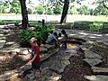 Children playing in the stream at Franklin Park in Prairie Village, Kansas
 Children playing on playground equipment


References
- "2019 U.S. Gazetteer Files". United States Census Bureau. Retrieved July 24, 2020.
- "QuickFacts; Prairie Village, Kansas; Population, Census, 2020 & 2010". United States Census Bureau. Archived from the original on August 24, 2021. Retrieved August 24, 2021.
- "U.S. Census website". United States Census Bureau. Retrieved January 31, 2008.
- "US Board on Geographic Names". United States Geological Survey. October 25, 2007. Retrieved January 31, 2008.
- "Monthly Average/Record Temperatures". Weather Channel. Retrieved September 1, 2015.
- "U.S. Census website". United States Census Bureau. Retrieved July 19, 2022.
- "2020 City Population and Housing Occupancy Status". U.S. Census Bureau. Retrieved July 19, 2022.
- "2010 City Population and Housing Occupancy Status". U.S. Census Bureau. Retrieved March 6, 2011.[dead link]
- "American FactFinder Income Data". U.S. Census Bureau. Archived from the original on February 11, 2020. Retrieved March 6, 2011.
- "City of Prairie Village, Kansas 2018 Comprehensive Annual Financial Report For the Year Ended December 31, 2018" (PDF). Retrieved April 29, 2021.
- "Sandahl Bergman". IMDb. Retrieved March 28, 2016.
- "Kansas Governor Robert F. Bennett". National Governors Association. Retrieved March 28, 2016.
Further reading
External links
- City of Prairie Village
- Prairie Village - Directory of Public Officials
- Prairie Village City Map, KDOT
Municipalities and communities of Johnson County, Kansas, United States | ||
|---|---|---|
County seat: Olathe | ||
| Cities |  | |
| Unincorporated communities |
| |
| Townships | ||
| Footnotes | ‡This community also has portions in an adjacent county or counties. | |
| ||
Kansas City metropolitan area's cities and counties | ||
|---|---|---|
| Central city |  | |
| Largest cities (over 100,000 in 2000) | ||
| Medium-sized cities (10,000 to 100,000 in 2000) | ||
| Smaller Cities (between 5,000 and 9,900 in 2010) | ||
| Counties | ||
| Authority control |
|
|---|
На других языках
[de] Prairie Village (Kansas)
Prairie Village ist eine Kleinstadt im US-amerikanischen Bundesstaat Kansas. Sie hat 21.447 Einwohner (Stand: 2010). Sie liegt im Johnson County und ist ein Vorort von Kansas City.- [en] Prairie Village, Kansas
Другой контент может иметь иную лицензию. Перед использованием материалов сайта WikiSort.org внимательно изучите правила лицензирования конкретных элементов наполнения сайта.
WikiSort.org - проект по пересортировке и дополнению контента Википедии