world.wikisort.org - USA
St. John the Baptist Parish (SJBP, French: Paroisse de Saint-Jean-Baptiste) is a parish located in the U.S. state of Louisiana. At the 2020 census, the population was 42,477.[1] The parish seat is Edgard,[2] an unincorporated area, and the largest city is LaPlace, which is also unincorporated.
St. John the Baptist Parish | |
|---|---|
Parish | |
 San Francisco Plantation House | |
| Motto: "Heart of the River Parishes" | |
 Location within the U.S. state of Louisiana | |
 Louisiana's location within the U.S. | |
| Coordinates: 30°07′N 90°30′W | |
| Country | |
| State | |
| Founded | 1807 |
| Named for | St. John the Baptist Catholic Church in Edgard, built 1772 |
| Seat | Edgard |
| Largest community | LaPlace |
| Area | |
| • Total | 348 sq mi (900 km2) |
| • Land | 213 sq mi (550 km2) |
| • Water | 135 sq mi (350 km2) 39% |
| Population (2020) | |
| • Total | 42,477 |
| • Density | 199.42/sq mi (77.00/km2) |
| Time zone | UTC−6 (Central) |
| • Summer (DST) | UTC−5 (CDT) |
| Congressional districts | 2nd, 6th |
| Website | www |
St. John the Baptist Parish was established in 1807 as one of the original 19 parishes of the Territory of Orleans, which became the state of Louisiana.[3]
St. John the Baptist Parish is part of the New Orleans–Metairie metropolitan statistical area.
This was considered part of the German Coast in the 18th and 19th centuries, named for numerous German immigrants who settled along the Mississippi River here in the 1720s. On January 8, 1811, the largest slave insurrection in US history, known as the German Coast Uprising, started here. It was short-lived, but more than 200 slaves gathered from plantations along the river and marched through St. Charles Parish toward New Orleans. This is part of the Sugarland or sugar parishes, which were devoted to sugar cane cultivation. Planters used large numbers of enslaved African-Americans before the war, and numerous freedmen stayed in the area to work on these plantations afterward.
The parish includes three nationally significant examples of 19th-century plantation architecture: Evergreen Plantation, Whitney Plantation Historic District, and San Francisco Plantation House.
History
Present-day St. John the Baptist Parish includes the third permanent settlement in what is now the state of Louisiana, after Natchitoches (1714) and New Orleans (1718). It was considered part of the German Coast. The area was settled in the early 1720s by a group of German colonists.[4] Many families established towns close to the Mississippi River in the areas now known as Lucy, Garyville, and Reserve. The area was under the French regime until 1763, when France ceded Louisiana to Spain after losing the Seven Years' War to Great Britain (this was known as the French and Indian War on the North American front).
At the beginning of the Spanish colonial period, many Acadians, people of French descent, began arriving in south Louisiana due to being expelled by the British from what is now Nova Scotia. The British took over French territory in Canada and in North America east of the Mississippi river. The first Acadian village was established in what is now Wallace, Louisiana. The German and French cultures thrived alongside one another, but French came to be the dominant language. They developed a culture known as Cajun.
In 1769, Acadians who settled in the area began a search for land to build a church. The governing Spanish authority at the time approved the request, and the land was expropriated on February 21, 1770. The first church stood in the same location as the modern St. John the Baptist Church. The new church carried the same name as the original chapel along the German Coast settlement. The first pastor was Spanish Capuchin Father Bernardo de Limpach. The first church records indicate a marriage between Antoine Manz and Sibylla Bischof in 1772. The first church stood tall until it was swept away by floodwaters in 1821.[5][6]
The early settlers in the area received land grants from the Spanish or French royal governments, depending upon which country owned the territory at the time of application. The French style of property allotments was made up of narrow frontage on the river so that each plantation had access for transportation of goods to and from New Orleans and world markets. The main house and supporting outbuildings were constructed near the river. The remaining property extended away from the river deeply into the wetlands, where land was cleared for cultivation of sugar cane.
Most transportation was done by boat, mainly on the bayous and lakes of the area, but via the Mississippi River as well, for decades into the 19th century. St. John, with its fertile land being nine feet above sea level, proved to be an excellent settlement for farming and agriculture. In the late 18th century, planters began to invest more in labor-intensive sugar cane cultivation and processing, increasing their demand for slave labor. Sugar production meant prosperity for the planters and New Orleans. Planters held large numbers of slaves, to the extent that the sugar and cotton parishes all had black majorities before the Civil War.
With the sugar wealth, some wealthy planters built elaborate houses and outbuildings. Three survive in St. John parish; each is recognized for its national architectural and historic significance. On the west bank are the major complex of house and outbuildings designated as the Whitney Plantation Historic District and the National Historic Landmark (NHL) of Evergreen Plantation. San Francisco Plantation House, also a designated NHL, is on the east bank. San Francisco and Evergreen plantations are open to the public for tours. The Whitney plantation house is planned for renovation. Whitney and Evergreen plantations are both included among the first 26 sites on the Louisiana African American Heritage Trail.
In January 1811, the German Coast Uprising started in this parish. It was the largest slave insurrection in US history, but it was short-lived. The slaves killed two whites, but suffered 96 deaths among their forces at the hands of the militia and in executions after quick trials afterward. They attacked five plantations and burned three houses to the ground. Charles Deslondes, a mulatto or mixed-race slave brought from Saint-Domingue before the success of its revolution, was one of the leaders of the insurrection. He and his followers were influenced by the ideals and promises of the French and Haitian revolutions. Slavery was ended on Saint-Domingue after the French Revolution, but reimposed before the slaves gained independence.[7]
Deslondes gathered more than 200 slaves from plantations along the way, marching upriver into St. Charles Parish toward New Orleans before meeting much resistance. Unable to get the arms they had planned on, the slaves were defeated by the well-armed informal and territorial militias. During these confrontations and executions after brief trials, Deslondes and ninety-five slaves were killed. Decades before the American Civil War and emancipation, their actions expressed African Americans' deep desire for freedom.[7]
As the number of white families in the settlement increased, they wanted education for their children. Before the Civil War, typically planters would hire tutors, often college graduates from the North, who would live with the family for an extended period of time, typically two years. The tutor would teach all of the planter's children, and sometimes the family would arrange for other neighborhood children to join the classes as well.
In 1869, following the Civil War, families wanting French instruction founded private schools to continue their culture. The Reconstruction legislature established the first public schools in the state during this period, but it took time for the state to arrange adequate funding for public education. The first high schools at Edgard and Reserve were not built until 1909. Students traveled to the schools by horse-drawn buses or by train.
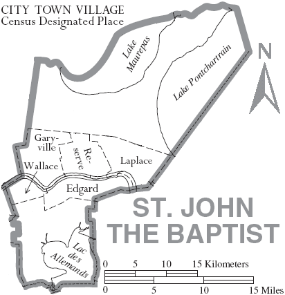
Geography
According to the U.S. Census Bureau, the parish has a total area of 348 square miles (900 km2), of which 213 square miles (550 km2) are land and 135 square miles (350 km2) (39%) are water.[8] It is the third-smallest parish in Louisiana by land area and fifth-smallest by total area.
St. John the Baptist Parish, Louisiana is located on the Mississippi River approximately 130 miles (210 km) upriver from the Gulf of Mexico and 30 miles (48 km) upriver from the City of New Orleans. The area, known as the River Region, has an abundance of natural resources and a mild "Sunbelt" climate. The average monthly temperature in New Orleans ranges from 55.1 °F (12.8 °C) in January to 83.7 °F (28.7 °C) in July, and rainfall averages 53.2 inches (135 cm) per year with monthly averages running from 2.52 inches (6.4 cm) in October to 7.17 inches (18.2 cm) in July. The New Orleans/River Region contains a good supply of raw materials, which has helped Louisiana maintain a high rank in the United States in the production of natural gas, petroleum, sulfur, salt, and fur pelts. High silica sands, lime, clays, timber, seafood, and various agricultural products are also produced in abundance.
St. John the Baptist Parish is bisected by the Mississippi River. Though the River separates the Parish into northern and southern parts, the former is still referred to as the "east bank" and the latter as the "west bank," referring to the direction of the river as it reaches the Gulf of Mexico. The Mississippi provides an important transportation corridor which supports the heavy industry located in the area.
St. John the Baptist Parish is bordered by St. Charles Parish and Lake Pontchartrain to the east, Lake Pontchartrain and Lake Maurepas to the north, Lafourche Parish and Lac des Allemands to the south, and St. James Parish to the west. It is one of four parishes which comprise the "River Parishes;" St. John Parish is the heart of the "River Parishes."
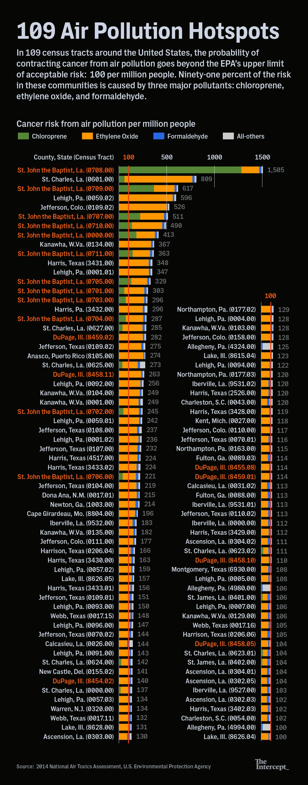
This section of the state, also consisting of St. James, Ascension, and St. Charles Parishes, makes up the area along the Mississippi River between New Orleans and Baton Rouge. Since the mid-20th century, when the oil industry developed from resources found here, all of these parishes are home to at least one major chemical- and/or petroleum-processing facility. The industry is the major source of employment in the region but it has had adverse environmental effects. St. John the Baptist parish has the highest rate of environmental cancer of any census tract in the United States.[9]
Much of the parish is either open water or wetlands. The wetlands are currently protected by federal law and development is limited to what is permitted by the U.S. Army Corps of Engineers and/or the Federal Wildlife and Fisheries Department.
Higher ground in the parish is found in an alluvial plain which generally borders the Mississippi River on both sides. Soil deposits from the Mississippi's annual flooding created a rich and fertile area which has historically been intensively farmed (sugar cane, soybeans, feed corn, and occasional cotton). This fact, and the natural transportation corridor supplied by the river, resulted in the creation of numerous plantations and farms along the lower Mississippi Valley.
Many of these plantations were large tracts of land with modest or average-sized homes and outbuildings found on the higher ground. Several, however, were improved with palatial mansions. Three of the larger homes have survived in St. John Parish, as noted in the History above.
The higher ground along the banks was used to grow crops, while the wetlands were valued for their abundant timber, hunting and fishing. For years development in the River Parishes was limited to those areas that were naturally higher and less prone to flooding. Until the existing levees and pump systems were built, however, few places were truly safe from high water. Even today, most of the parish is considered a flood hazard area according to FEMA Flood Maps.[10]
Adjacent parishes
- Tangipahoa Parish (north)
- St. Charles Parish (southeast)
- Lafourche Parish (south)
- St. James Parish (west)
- Ascension Parish (northwest)
- Livingston Parish (northwest)
Communities
St. John the Baptist Parish has no incorporated areas.
Census-designated places
Unincorporated communities
- Mount Airy
- Welcome
- Dutch Bayou
- Cornland
- Lions
Ghost Towns
- St. John the Baptist Parish had two more communities on its east bank, Ruddock and Frenier, which were settled on the isthmus between Lake Maurepas and Lake Pontchartrain, 10 miles (16.093 km) NNE of LaPlace. In 1892, Ruddock founded by the Ruddock Cypress Company was made into a sawmill town. In September 1915, the 1915 New Orleans Hurricane hit Ruddock and the nearby town of Frenier, destroying the towns and killing some of the residents. Today, Ruddock and Frenier are ghost towns in the parish as well as memorials to themselves. All that remains of Ruddock is rotted wood from Buildings and vegetation. Yet Freneir still has a few buildings being seafood restaurants and a small number of houses all of which are built high to prevent flooding. Nevertheless, Ruddock is still marked on an I-55 exit sign and both are seen on Louisiana road maps, Freneir still has an entrance sign on Highway 51 marking it as a fishing village. It can be seen off I-10 on Lake Pontchartrain.
Demographics
| Historical population | |||
|---|---|---|---|
| Census | Pop. | %± | |
| 1820 | 3,854 | — | |
| 1830 | 5,677 | 47.3% | |
| 1840 | 5,776 | 1.7% | |
| 1850 | 7,317 | 26.7% | |
| 1860 | 7,930 | 8.4% | |
| 1870 | 6,762 | −14.7% | |
| 1880 | 9,686 | 43.2% | |
| 1890 | 11,359 | 17.3% | |
| 1900 | 12,330 | 8.5% | |
| 1910 | 14,338 | 16.3% | |
| 1920 | 11,896 | −17.0% | |
| 1930 | 14,078 | 18.3% | |
| 1940 | 14,766 | 4.9% | |
| 1950 | 14,861 | 0.6% | |
| 1960 | 18,439 | 24.1% | |
| 1970 | 23,813 | 29.1% | |
| 1980 | 31,924 | 34.1% | |
| 1990 | 39,996 | 25.3% | |
| 2000 | 43,044 | 7.6% | |
| 2010 | 45,924 | 6.7% | |
| 2020 | 42,477 | −7.5% | |
| U.S. Decennial Census[11] 1790-1960[12] 1900-1990[13] 1990-2000[14] 2010-2013[15] | |||
| Race | Number | Percentage |
|---|---|---|
| White (non-Hispanic) | 13,348 | 31.42% |
| Black or African American (non-Hispanic) | 24,076 | 56.68% |
| Native American | 105 | 0.25% |
| Asian | 314 | 0.74% |
| Pacific Islander | 7 | 0.02% |
| Other/Mixed | 1,336 | 3.15% |
| Hispanic or Latino | 3,291 | 7.75% |
The 2019 census estimates determined 42,242 people lived in the parish.[17] The racial and ethnic makeup of the parish was 56.5% Black and African American, 38.2% non-Hispanic white, 1.1% Asian, 2.7% some other race, and 1.5% multiracial; of the population, 6.1% were Hispanic and Latin American of any race. Among the population, Spanish was the second most-spoken language as of 2019; approximately 4.0% of the parish population were foreign-born. French ancestry was the largest heritage among the parish population (9.7%).
In 2019, there were 15,720 households living in 17,778 housing units. There were also 3,758 businesses operating in the parish, with the majority being minority-owned.[17] The parish had an employment rate of 56.2% in 2019, and 78.5% of the population lived in owner-occupied units. The median home value was $153,900, and median gross rent was $933. The median household income was $57,429; males had a median income of $53,849 versus $36,476 for females. An estimated 24.8% of the population lived at or below the poverty line.[17]
By the publication of the 2020 United States census, there were 42,477 people, 15,270 households, and 11,104 families residing in the parish.[16] Among the parish population, 56.68% of the population were Black and African American, 31.42% non-Hispanic white, 0.25% Native American, 0.74% Asian, 0.02% Pacific Islander, 3.15% multiracial or some other race, and 7.75% Hispanic or Latin American of any race. The increase in Hispanic or Latinos and other non-White Americans has been attributed to a nationwide demographic shift.[18][19]
Government
| Parish Administration | Administrators |
|---|---|
| Parish President | Jaclyn S. Hotard |
| Sheriff | Michael K. Tregre |
| Coroner | Dr. Christy Montegut |
| Assessor | Lucien J. Gauff, III |
| School Board Superintendent | Dr. Lynette Hookfin |
| Parish Council | Councilmembers |
|---|---|
| Council Chairman | Lennix Madere, Jr. |
| Council Vice-Chair | Kurt Becnel |
| Council Seat At Large, Division A | Lennix Madere, Jr. |
| Council Seat At Large, Division B | Michael Wright |
| Council Seat District I | Kurt Becnel |
| Council Seat District II | Warren "Bosco" Torres Jr. |
| Council Seat District III | Tammy Houston |
| Council Seat District IV | Tyra Duhe-Griffin |
| Council Seat District V | Robert J. Arcuri |
| Council Seat District VI | Tonia Schnyder |
| Council Seat District VII | Thomas A. Malik |
| 40th Judicial District | Parish Judicial Leaders |
|---|---|
| Judge of Division "A" | Madeline Jasmine |
| Judge of Division "B" | Jeffrey Perriloux |
| Judge of Division "C" | Sterling Snowdy |
| 5th Circuit Court of Appeal, Judge of Division "H" | Jude Gravois |
| District Attorney | Bridget A. Dinvaut |
| Clerk of Court | Eliana DeFrancesch |
| Senators & Representatives | Names | Notes |
|---|---|---|
| State Senator | Troy Brown D-2 D | |
| State Senator | Gary Smith D-19 D | |
| State Representative | Randal L. Gaines D-57 D | |
| State Representative | Clay Schexnayder D-81 R | |
| State Representative | Gregory A. Miller D-56 R | |
| U.S. Senator | Bill Cassidy R | |
| U.S. Senator | John Kennedy R | |
| U.S.Representative | Garret Graves 6th District R | |
| U.S.Representative | Troy Carter 2nd District D |
| Parish School Board | Board Members |
|---|---|
| Board President | Albert Burl, III |
| Board Vice President | Patrick H. Sanders |
| District I | Charo Holden |
| District II | Albert Burl, III |
| District III | Gerald J. Keller, Ph.D. |
| District IV | Patrick H. Sanders |
| District V | Sherry DeFrancesch |
| District VI | Keith Jones |
| District VII | Phillip Johnson |
| District VIII | Russ Wise |
| District IX | Shawn Wallace |
| District X | Nia Mitchell |
| District XI | Clarence Triche |
St. John the Baptist Parish leans heavily towards the Democratic Party. It has not voted for a Republican presidential candidate since Ronald Reagan in 1984, and before that voted Republican only two other times in the 20th century: for Warren G. Harding in 1920, when Acadian voters broke with President Woodrow Wilson over various issues,[20] and for Richard Nixon in 1972, when he won all but one parish in Louisiana. It also supported the third-party bid of George Wallace in 1968.
Prior to passage of the 1898 constitution, which almost completely disenfranchised black voters and made Louisiana an effective one-party state, St. John the Baptist Parish generally voted Republican.[21] In fact, it did so in every presidential election from 1872 until 1896.
At the state level, the parish is also heavily Democratic. St. John the Baptist was Governor John Bel Edwards' second strongest in the 2019 election, giving him 74% of the vote.
| Year | Republican | Democratic | Third parties |
|---|---|---|---|
| 2020 | 35.2% 7,538 | 63.4% 13,582 | 1.5% 312 |
| 2016 | 36.5% 7,569 | 61.0% 12,661 | 2.5% 513 |
| 2012 | 36.1% 7,620 | 62.4% 13,179 | 1.5% 324 |
| 2008 | 41.2% 8,912 | 57.4% 12,424 | 1.5% 320 |
| 2004 | 46.1% 9,039 | 52.5% 10,305 | 1.4% 273 |
| 2000 | 41.9% 7,423 | 55.0% 9,745 | 3.1% 545 |
| 1996 | 35.3% 6,025 | 58.3% 9,937 | 6.4% 1,089 |
| 1992 | 37.7% 6,730 | 50.3% 8,977 | 12.0% 2,144 |
| 1988 | 46.0% 7,464 | 51.6% 8,366 | 2.4% 389 |
| 1984 | 54.0% 9,093 | 45.4% 7,646 | 0.7% 112 |
| 1980 | 42.0% 5,819 | 55.2% 7,647 | 2.9% 395 |
| 1976 | 37.4% 3,597 | 59.3% 5,700 | 3.3% 312 |
| 1972 | 49.8% 3,525 | 39.7% 2,815 | 10.5% 746 |
| 1968 | 12.7% 940 | 43.7% 3,245 | 43.7% 3,246 |
| 1964 | 30.0% 1,694 | 70.0% 3,958 | |
| 1960 | 10.3% 488 | 80.1% 3,782 | 9.5% 450 |
| 1956 | 50.6% 1,372 | 47.1% 1,278 | 2.4% 64 |
| 1952 | 23.5% 654 | 76.5% 2,132 | |
| 1948 | 20.2% 379 | 42.5% 799 | 37.3% 702 |
| 1944 | 12.8% 195 | 87.2% 1,324 | |
| 1940 | 19.3% 285 | 80.7% 1,192 | |
| 1936 | 13.1% 262 | 86.9% 1,742 | |
| 1932 | 17.5% 176 | 79.6% 799 | 2.9% 29 |
| 1928 | 10.8% 118 | 89.2% 971 | |
| 1924 | 36.6% 194 | 63.4% 336 | |
| 1920 | 51.1% 250 | 48.9% 239 | |
| 1916 | 27.9% 115 | 70.2% 289 | 1.9% 8 |
| 1912 | 23.9% 74 | 61.3% 190 | 14.8% 46 |
Education
The St. John the Baptist Parish School Board operates 10 public schools within the parish, the Archdiocese of New Orleans oversees 5 religious schools within the parish and there are 2 privately run schools within the parish.
| Public Schools | City/Town | 2013-2014 Letter Grade (SPS) | Change from 2012 to 2013 grade |
|---|---|---|---|
| Laplace Elementary/Middle School | LaPlace | B (89.0) | +2.90 |
| Garyville-Mt. Airy Math and Science Magnet School | Garyville/Mt. Airy | C (73.7) | -0.50 |
| Fifth Ward Elementary School | Reserve | C (71.5) | +3.50 |
| East St. John Elementary/Middle School | Reserve | C (79.4) | +3.20 |
| Emily C. Watkins Elementary/Middle School | LaPlace | C (80.6) | +14.30 |
| John L. Ory Communications Magnet School | LaPlace | A (106.7) | -2.50 |
| Lake Pontchartrain Elementary/Middle School | LaPlace | D (61.3) | -11.30 |
| West St. John Elementary/Middle School | Edgard | D (62.8) | +1.90 |
| East St. John High School | Reserve | C (75.8) | N/A |
| West St. John High School | Edgard | B (98.6) | +6.90 |
http://www.louisianabelieves.com/data/reportcards/2013/
| Religious Schools | City/Town |
|---|---|
| Ascension of Our Lord Catholic Elementary/Middle School | LaPlace |
| St. Joan of Arc Catholic Elementary/Middle School | LaPlace |
| St. Peter's Catholic Elementary/Middle School | Reserve |
| Our Lady of Grace Catholic Elementary/Middle School | Reserve |
| St. Charles Catholic High School | LaPlace |
| St. Timothy's Episcopal School | LaPlace |
| Private Schools | City/Town |
|---|---|
| Reserve Christian Elementary/Middle School | Reserve |
| Riverside Academy K-12 | Reserve |
It is in the service area of Delgado Community College.[23]
National Guard
The 1084th Transportation Company of the 165th CSS Battalion of the Louisiana National Guard resides in Reserve, Louisiana.
Transportation
Major highways
 Interstate 10
 Interstate 55
 U.S. Highway 51
 U.S. Highway 61
 Louisiana Highway 18
 Louisiana Highway 44
 Louisiana Highway 3127
 Louisiana Highway 3188
 Louisiana Highway 3213
East Bank - The primary artery on the east bank of St. John Parish is Airline Highway (U.S. Highway 61). This five-lane, asphalt-paved road was once the predominant route linking Baton Rouge and New Orleans. Though it is still heavily traveled, much of the New Orleans-Baton Rouge traffic has been diverted to Interstate 10, located in the northern part of the parish. Interstate 10, a divided, controlled-access highway, has two interchanges in St. John Parish; one at Belle Terre Boulevard and the second at U.S. Highway 51/Interstate 55, both in LaPlace. Both Belle Terre Boulevard and Highway 51 intersect Airline Highway approximately 3.5 miles (5.6 km) south of Interstate 10.
Interstate 55, a north–south route leading to Jackson, Mississippi, and beyond, intersects Interstate 10 in the northeastern sector of LaPlace. A third Interstate 10 interchange exists just west of the St. John Parish line near Gramercy (St. James Parish).
River Road, also known as Jefferson Highway or Louisiana Highway 44, is a two-lane, asphalt-paved, winding highway which parallels the Mississippi River. Most of the heavy industry in the parish fronts on this road.
West Bank - Most of the development on the west bank lies along Louisiana Highway 18 (the Great River Road), a two-lane, asphalt-paved highway which parallels the Mississippi River similarly to Highway 44 on the east bank. In addition to Louisiana 18, the west bank has Louisiana Highway 3127 or the River Parishes Highway, which is roughly equivalent to the east bank's Airline Highway in that it follows the Mississippi. It is not as winding nor as populated as River Road. Highway 3127 leads to Donaldsonville upriver from St. John Parish. It is home of the "Sunshine Bridge" over the Mississippi River in Ascension Parish. This road has little development on either side and is generally surrounded by wetlands in St. John Parish.
Veterans Memorial Bridge or Gramercy Bridge - (Louisiana Highway 3213) This bridge originates on the east bank of St. James Parish near Gramercy/Lutcher and has access to I-10 and Airline Highway via Louisiana Highway 641. The foot of the bridge on the west bank is in St. John Parish near Wallace, with a tie-in to Louisiana Highway 3127 that opened June 18, 2008. The opening of this bridge has spurred the development hoped for along the west bank of St. John Parish. (The bridge is known as the "Bridge to Nowhere.")
Access to the west bank of St. John Parish is also provided by a ferry crossing at Reserve/Edgard and by the Hale Boggs Memorial Bridge over the Mississippi in St. Charles Parish.
See also
- National Register of Historic Places listings in St. John the Baptist Parish, Louisiana
- German Coast
- 1811 German Coast Uprising
- River Parishes
References
- "QuickFacts: St. John the Baptist Parish, Louisiana". U.S. Census Bureau. Retrieved August 12, 2021.
{{cite web}}: CS1 maint: url-status (link) - "Find a County". National Association of Counties. Retrieved June 7, 2011.
- "St. John the Baptist Parish". Center for Cultural and Eco-Tourism. Retrieved September 6, 2014.
- First Families – The Pioneers, scphistory.org
- Tricentennial Thursday: St. John the Baptist, Edgard, among oldest parishes, clarionherald.org, February 22, 2018
- Brooke Robichaux: St. John the Baptist Church commemorates 100 years, lobservateur.com, 2020-10-28
- Adam Rothman, Slave Country: American Expansion and the Origins of the Deep South, pp. 106-117, Cambridge, MA: Harvard University Press, 2007 paperback
- "2010 Census Gazetteer Files". United States Census Bureau. August 22, 2012. Archived from the original on September 28, 2013. Retrieved September 1, 2014.
- https://theintercept.imgix.net/wp-uploads/sites/1/2019/02/AirPollutionList12-1550942329.jpg?auto=compress%2Cformat&q=90 [bare URL image file]
- "Flood Insurance Rate Map: St. John the Baptist Parish, Louisiana (November 4, 2010)" (PDF). Retrieved March 6, 2018.
- "U.S. Decennial Census". United States Census Bureau. Retrieved September 1, 2014.
- "Historical Census Browser". University of Virginia Library. Retrieved September 1, 2014.
- "Population of Counties by Decennial Census: 1900 to 1990". United States Census Bureau. Retrieved September 1, 2014.
- "Census 2000 PHC-T-4. Ranking Tables for Counties: 1990 and 2000" (PDF). United States Census Bureau. Retrieved September 1, 2014.
- "State & County QuickFacts". United States Census Bureau. Retrieved August 18, 2013.
- "Explore Census Data". data.census.gov. Retrieved December 28, 2021.
- "Geography Profile: St. John the Baptist Parish, Louisiana". data.census.gov. Retrieved August 2, 2021.
{{cite web}}: CS1 maint: url-status (link) - "The Chance That Two People Chosen at Random Are of Different Race or Ethnicity Groups Has Increased Since 2010". Census.gov. Retrieved February 16, 2022.
- "US's white population declines for first time ever, 2020 census finds". the Guardian. August 13, 2021. Retrieved February 16, 2022.
- See Howard, Perry H.; Political Tendencies in Louisiana, 1812-1952 (Baton Rouge: Louisiana State University Press, 1957), p. 144, also maps on pp. 145 and 151.
- Phillips, Kevin P.; The Emerging Republican Majority, pp. 208, 210 ISBN 9780691163246
- Leip, David. "Dave Leip's Atlas of U.S. Presidential Elections". uselectionatlas.org. Retrieved February 20, 2021.
- "Our Colleges". Louisiana's Technical and Community Colleges. Retrieved June 3, 2021.
External links
Places adjacent to St. John the Baptist Parish, Louisiana | ||||||||||||||||
|---|---|---|---|---|---|---|---|---|---|---|---|---|---|---|---|---|
| ||||||||||||||||
Municipalities and communities of St. John the Baptist Parish, Louisiana, United States | ||
|---|---|---|
Parish seat: Edgard | ||
| CDPs |  | |
| Other communities | ||
| Ghost town | ||
| Footnotes | ‡This populated place also has portions in an adjacent parish | |
| ||
Authority control | |
|---|---|
| General | |
| National libraries | |
| Other |
|
На других языках
[de] St. John the Baptist Parish
Das St. John the Baptist Parish[1] (französisch Paroisse de Saint-Jean-Baptiste) ist ein Parish im Bundesstaat Louisiana der Vereinigten Staaten. Im Jahr 2000 hatte das Parish 45.924 Einwohner und eine Bevölkerungsdichte von 81 Einwohner pro Quadratkilometer. Der Verwaltungssitz (Parish Seat) ist Edgard.- [en] St. John the Baptist Parish, Louisiana
[ru] Сент-Джон-те-Баптист
Прихо́д Сент-Джон-те-Баптист (англ. Saint John the Baptist Parish) или Сен-Жан-Батист (фр. Paroisse de Saint-Jean-Baptiste) — один из приходов штата Луизиана, США. Официально образован в 1807 году. По состоянию на 2010 год, численность населения составляла 45 924 человека.Другой контент может иметь иную лицензию. Перед использованием материалов сайта WikiSort.org внимательно изучите правила лицензирования конкретных элементов наполнения сайта.
WikiSort.org - проект по пересортировке и дополнению контента Википедии